Christine Harris (2026)
Demographics
Region: Mid West
LGA: Sandstone
Industry: Coaching Inn
Open Street Map: -28.00926510086364, 118.99632718469826
What3Words: ///tribes.prodigal.uneducated
Settled: About 1900
Abandoned: About 1910
Abstract
This historical account examines the transformation of Western Australia’s Murchison Goldfields, detailing how the 1890s gold rush reshaped isolated pastoral lands into industrial hubs. It highlights the pivotal role of wayside inns, such as the 71 Mile Well, which functioned as essential social and logistical anchors for coach travellers. The narrative chronicles the rise of vital infrastructure, including State Batteries and grand hotels, and their subsequent decline as the expansion of the railway rendered traditional coaching routes obsolete. Ultimately, the story of 71 Mile Well serves as a model for the heritage significance and “sense of place” preserved within these now-abandoned ghost towns.
History
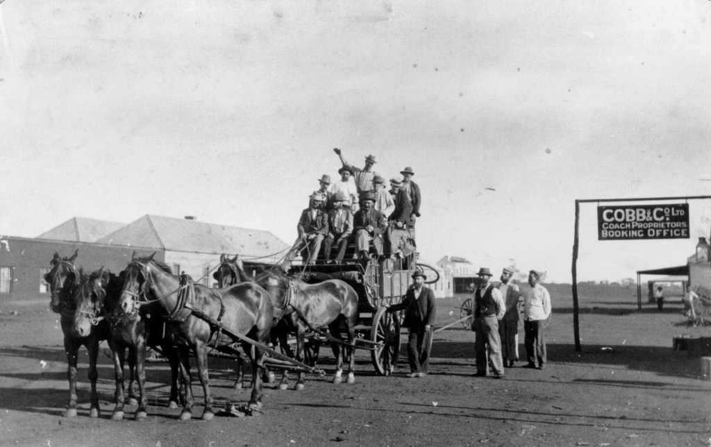
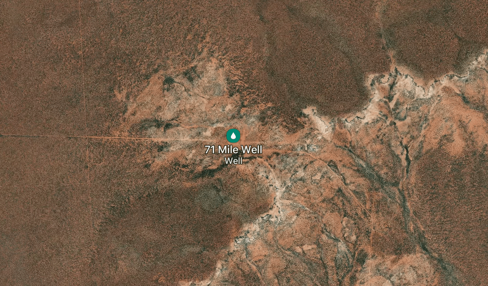
The 71 Mile Well is situated in the Sandstone region of Western Australia, approximately 506 metres above sea level. During the peak of the gold rushes in the late 19th and early 20th centuries, it functioned as a critical coach staging post for Cobb & Co. on the road between Sandstone and Mount Magnet. Like many “numbered” wells in the district, it defined the geography of survival for travellers, teamsters, and prospectors in the arid “Never Never” country.1 2
The Importance of Wayside Inns and Coaching Stops
Wayside inns like the one at 71 Mile Well were the lifeblood of regional transport. These outposts were often the only places to obtain “shelter and food” in a waterless landscape. Similar to the Twelve-Mile settlement (Yaloginda), which served as an overnight stop for coaches before the railway reached Meekatharra in 1910, 71 Mile Well provided the infrastructure necessary for the pre-railway era. The well itself was part of a broader network of government wells, such as the 25 Mile Well, which were sunk at regular intervals to support drovers and their stock. 3
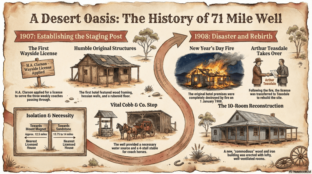
1907: The Struggle for Legitimacy
By late 1907, the locality’s importance as a service point was growing. In September 1907, H.A. Clarson applied to the Black Range Licensing Court for a Wayside House licence. The economic necessity was clear: Clarson testified that three coaches arrived from Mount Magnet weekly, with two staying overnight and others calling for breakfast.
However, the application faced political and social hurdles. It was opposed by local rivals and the police, who argued the premises—consisting of wood framing with hessian walls and an iron roof—were unsuitable. Despite these “primitive” conditions, Constable M’Arthur supported the need for the licence, noting that travellers required the accommodation. The court adjourned the case to allow Clarson to secure a formal title to the land.5
1908: Fire and Reconstruction
The locality suffered a significant setback on New Year’s Day, 1908, when the original wayside hotel premises were destroyed by fire. This event marked a transition in the site’s history. Discouraged by the loss, Clarson sold his newly granted licence to Arthur Teasdale.
Teasdale immediately invested in the site’s economic future, erecting a more substantial 10-roomed hotel made of wood and iron. The new building featured lofty, well-ventilated rooms and was designed to better cater to the “travelling public” moving between the major mining hubs. By March 1908, Teasdale was officially granted his wayside licence.6 7 8
The “Master Mariner” Floods
In May 1908, the locality faced severe environmental challenges. After nine months of dry weather, heavy rains turned the Mount Magnet Road into a quagmire. The 30-mile stretch between 71 Mile Well and Moore’s was described as “exceptionally bad,” requiring “careful navigation”. One teamster famously remarked that while he could drive well enough, it now required a “master mariner” to complete the trip and deliver goods. Such conditions frequently isolated these outposts and disrupted the economic flow of supplies to the goldfields.9
The Decline
The decline of the 71 Mile Well as a commercial locality was driven by two primary factors:
- Economic/Technological Shift: The expansion of the railway network, reaching Nannine in 1903 and Meekatharra in 1910, rendered slow, overnight coach travel obsolete. As steam trains replaced horse-drawn coaches, the staging posts lost their primary customer base.
- Mining Fluctuations: As gold production fell and populations shifted toward larger centres like Sandstone or Meekatharra, many wayside hotels became non-viable.10
Today, the 71 Mile Well is a ghost town. It remains a landmark on the Sandstone–Mount Magnet Road, representing a way of life from the pioneering gold-mining era.
Timeline
- Late 1800s – Early 1900s: The locality serves as a critical coach staging post for Cobb & Co. on the road connecting Sandstone and Mount Magnet.
- September 1907: H.A. Clarson applies for a Wayside House licence for premises at the well. The application is initially adjourned to allow Clarson to secure a formal title to the land. At this time, the site consists of a wood-framed building with hessian walls and an iron roof, featuring four bedrooms and a four-stall stable.
- 1 January 1908: The original wayside hotel premises are destroyed by fire.
- Early 1908: Discouraged by the fire, Clarson sells his newly granted licence to Arthur Teasdale. Teasdale commissions the construction of a more substantial 10-roomed hotel built of wood and iron, featuring lofty, well-ventilated rooms.
- March 1908: The Sandstone Licensing Court officially grants the wayside licence to Arthur Teasdale for the new 71 Mile Well hotel.
- May 1908: After nine months of drought, heavy rains leave the road between 71 Mile Well and Moore’s in a “frightful state,” requiring “careful navigation” by coach drivers.
- June 1908: Records indicate Teasdale is still operating the hotel at the site.
- Present Day: The 71 Mile Well is no longer inhabited and is classified as a ghost town site, having once hosted a registered trade but now conducting no business. It remains a geographical landmark in the Shire of Sandstone at an elevation of 506 metres.
Map
Sources
- Morawa Historical Society (n.d.) 71 Mile Well. Retrieved 28 Feb 2026 from https://morawamuseum.org.au/ghosttowns/number.pdf ↩︎
- Mapcarta (2026). 71 Mile Well. Retrieved 28 Feb 2026 from https://mapcarta.com/30038944
↩︎ - Licensing Court. (1907, September 13). The Black Range Courier and Sandstone Observer (WA : 1907 – 1915), p. 2. Retrieved February 28, 2026, from http://nla.gov.au/nla.news-article201949386 ↩︎
- State Library of Western Australia (n.d.) Paris International Exhibition of 1900 collection of photographs; 2946B/1. Retrieved 28 Feb 2026 from https://encore.slwa.wa.gov.au/iii/encore/record/C__Rb1920084 ↩︎
- Licensing Court: refers to facilities ↩︎
- Local and General News. (1908, March 6). The Black Range Courier and Sandstone Observer (WA : 1907 – 1915), p. 2. Retrieved February 28, 2026, from http://nla.gov.au/nla.news-article201950152 ↩︎
- Morawa H.S.: refers to Teasdale ↩︎
- Sandstone Licensing Court. (1908, March 13). The Black Range Courier and Sandstone Observer (WA : 1907 – 1915), p. 3. Retrieved February 28, 2026, from http://nla.gov.au/nla.news-article201950187 ↩︎
- Local and General News. (1908, May 1). The Black Range Courier and Sandstone Observer (WA : 1907 – 1915), p. 2. Retrieved February 28, 2026, from http://nla.gov.au/nla.news-article201950418 ↩︎
- Gray, Laura (2012). Shire of Meekatharra Heritage Inventory Review 2012. Retrieved 28 Feb 2026 from https://www.meekashire.wa.gov.au/documents/465/municipal-heritage-list ↩︎
- Mapcarta (2026). 71 Mile Well. Retrieved 28 Feb 2026 from https://mapcarta.com/30038944 ↩︎
Further Reading
- SENIOR, Sally L. – From Gold to Wool and Back Again. A District History, 1995, Shire of Sandstone.
