
Christine Harris (2026
Demographics
Region: Wheatbelt
LGA: Kellerberrin
Industry: Agriculture
Other Names: Bandee, Lake Baandee, Baandui, Barndi, Barndy
Open Street Map: -31.51209671659034, 117.9813214764156
What3Words: ///echoed.surfaces.entry
Settled:1897
Gazetted: 1912
Abandoned: 1970
Abstract
This article explores the historical trajectory of Baandee, Western Australia, a settlement once vital to the Wheatbelt but now primarily recognised as a recreational lake. The account begins with the pre-colonial occupation by the Njakinjaki Noongar people, whose language provided the town’s name—variously interpreted as “shimmer,” “sweat,” or “to smell”—capturing the unique environmental characteristics of the local ephemeral salt lake system.
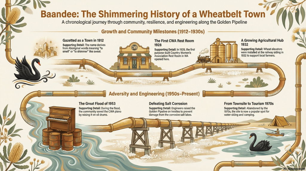
Following European exploration, the town was formally gazetted in April 1912, developing rapidly around its railway siding to include a post office, farmer’s co-operative, and agricultural hall. A significant social landmark was established in 1928 with the construction of the state’s first purpose-built Country Women’s Association (CWA) Rest Room, symbolising the town’s importance to rural families. The article examines the economic foundations of the town, including its roles in wheat storage through innovative engine-powered elevators and the hand-mining of salt and gypsum from the lake beds.
However, the town’s prosperity was undermined by environmental and political factors. The corrosive and flood-prone nature of the salt lakes presented immense challenges for the Goldfields Water Supply Scheme, requiring unique engineering solutions like wooden trestles for the pipeline. Frequent inundations, culminating in the devastating 1953 floods, physically isolated the town and damaged infrastructure. The decline was accelerated in the 1960s by the rise of motor vehicle travel and the political decision to bypass the town with the new broad-gauge railway line. By the 1970s, Baandee was abandoned, leaving behind a legacy of pioneering spirit now preserved through the relocation of its heritage buildings and the lake’s continued use for water sports.
History
The Traditional Landscape and Pre-History
Long before the arrival of the Great Eastern Highway, the area known as Baandee was the domain of the Njakinjaki language group, part of the broader Noongar people. The landscape is defined by an ancient drainage zone of broad, flat valley floors and a chain of salt lakes. To the traditional owners, the name “Baandee” carried meanings deeply rooted in the environment: “shimmer in a silvery fashion” or “of perspiration and sweat,” referring to the sun’s glare reflecting off the salt crust of the dry lake beds. At various times the name was recorded as Barndi, Barndy and Baandui.
Early European explorers in the mid-19th century, such as C.C. Hunt, traversed this arid interior, often relying on the guidance of Aboriginal people to locate vital water sources like gnammas and soaks. The local geography presented a stark contrast of open woodlands—comprising York gum, salmon gum, and gimlet—and the expansive, ephemeral salt lakes that would later dictate the town’s survival.1 2 3 4 5
Gazettal and the Golden Age of the Railway
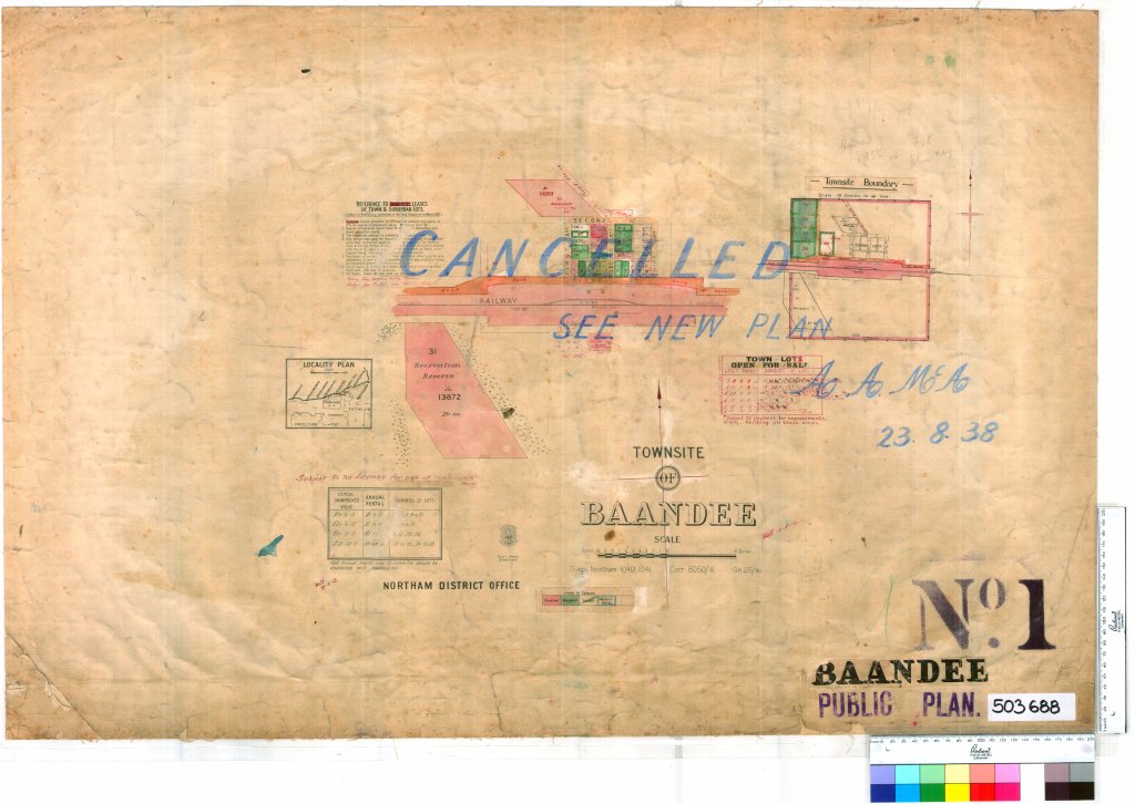
As the Western Australian agricultural frontier pushed eastward, the need for transit points between Kellerberrin and Merredin became apparent. Baandee was officially gazetted as a townsite in April 1912. It quickly became a vital node in the Wheatbelt’s logistical network, featuring its own railway siding, an agricultural hall, and a farmer’s co-operative store.
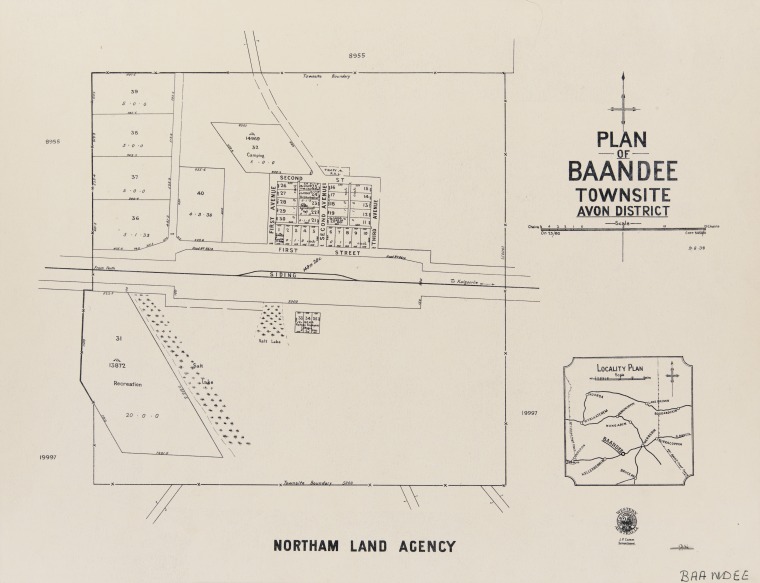
The town was a product of the “Age of Wheat.” In 1932, the Wheat Pool of Western Australia expanded the town’s industrial capacity by installing two engine-fitted wheat elevators onto new bins at the siding, significantly easing the storage and transport of grain for local farmers.7 8 9 10 11
Engineering Challenges: The Golden Pipeline
The town’s history is inextricably linked to the Goldfields Water Supply Scheme, or the “Golden Pipeline”. While the scheme was designed to carry water to the arid goldfields, the salt lakes at Baandee posed a major engineering hurdle. Elsewhere, pipes were buried, but the corrosive saline soil of the Baandee lakes made this impossible.
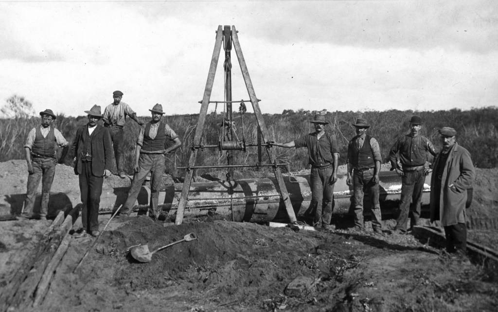
Jack Harry James12
Engineers under the legacy of C.Y. O’Connor were forced to lay the pipes on wooden trestles above the lake bed. To protect the water from the heat, the pipes were encased in corrugated iron frames packed with sawdust. Visitors today can still see the remains of these early wooden trestles and the concrete supports that later replaced them, standing as a testament to the town’s battle with its environment.13 14
Social Life and the “Cradle of the CWA”
Baandee’s social fabric was remarkably strong for a small siding. It earned a place in state history when the Country Women’s Association (CWA) chose it as the site for the first purpose-built Rest Room in Western Australia in 1928. This building was more than a meeting hall; it was a sanctuary for women and children living in the isolation of the remote Wheatbelt.15
Community life was marked by events such as the annual Baandee Railway Picnic, where railway employees and their families gathered for picnics at the lake, often enjoying free ice cream and drinks for the children. Prominent early residents like John Withnell Onn, a surveyor-turned-farmer who established “Inglenook” farm, were the backbone of the community. Onn was known for his cheerful salute at the siding and his constant attendance at public meetings until his sudden death in 1919.16
Economic Foundations: Salt and Gypsum
Beyond wheat, the lakes themselves provided a hard-won living. In the 1930s, Aboriginal men from the nearby Jureen Mission reserve scraped salt from the lake surface to sell to farmers for livestock. This work was punishing, as the glare from the salt in the bright sun was blinding. Politically, this income had to remain undeclared; if an Aboriginal person was found to have any income, they risked losing their rights to the weekly rations needed to feed their families.
The discovery of rich gypsum deposits in the 1930s birthed a new industry. Gypsum was hand-shovelled into skips on light rails and trucked to Doodlakine for transport to Perth. This industry flourished for three decades but was eventually defeated by the town’s greatest environmental foe: flooding.17
Environmental Adversity and the 1953 Floods
In a region defined by its aridity, the irony of Baandee was its vulnerability to water. Situated on a low-lying series of salt lakes, the town was frequently cut off during wet years. The 1953 floods were particularly devastating. The town was isolated for months, and the iconic CWA building was inundated. In a famous image of rural resilience, the branch’s piano was hoisted up onto 44-gallon oil drums to keep it above the floodwaters.18 19
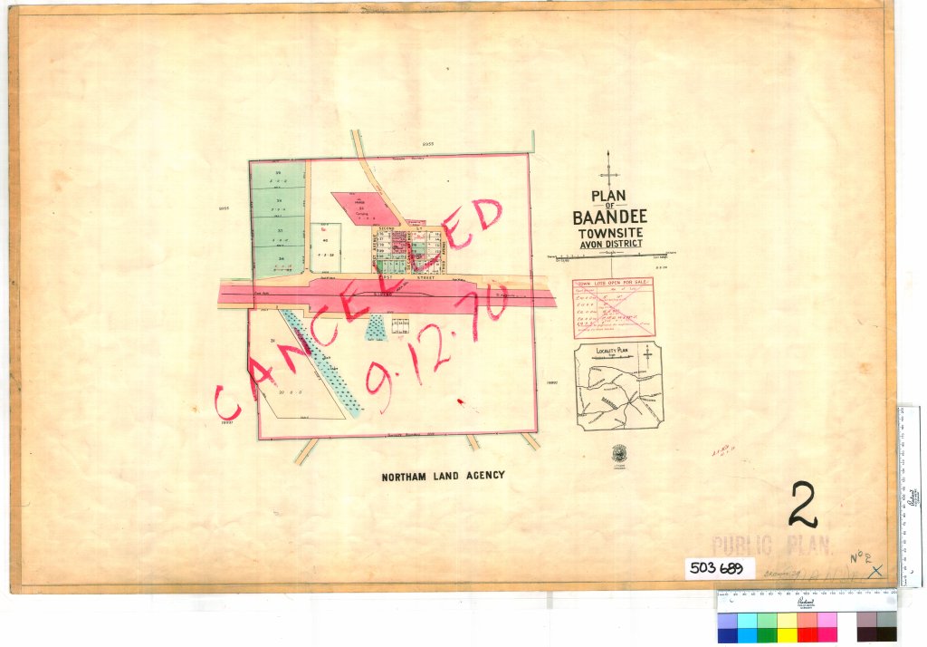
Decline and Abandonment
The decline of Baandee was a result of shifting economic and transport landscapes in the 1960s. The increasing prevalence of motor vehicles meant that larger regional centres like Kellerberrin and Merredin became more accessible, rendering small siding towns redundant.
The final political and economic blow came with the construction of the broad-gauge railway line, which bypassed the townsite. In 1968, the local CWA branch was forced to disband, and by the 1970s, the town was officially abandoned. The historical significance of the first CWA Rest Room was recognised, however, and the building was dismantled and relocated to Mangowine in Nungarin in 1974 to serve as a museum piece.20 21
Present Day: A Shimmering Oasis
Today, the Baandee townsite exists only as a heritage sign and a set of coordinates on a map. However, Baandee Lake remains a vibrant recreational landmark. When winter rainfall is sufficient, the Inland Water Ski Club maintains facilities for water skiing, swimming, and camping.
The lake attracts travellers who come for the “fantastic views” of intensely red sunsets and star-filled skies, echoing the “shimmering” beauty that gave the town its name over a century ago. While the structures of the town are gone, the spirit of Baandee persists in the ripples of the lake and the heritage trails of the Golden Pipeline.23 24 25
Timeline
Christine Harris, 2026
- Pre-colonial: Occupation by the Njakinjaki Noongar people.
- 1864: Explorer C.C. Hunt records nearby Doodlakine rocks.
- 1893: John Withnell Onn arrives in WA on the Victory.
- 1890s: Goldfields Water Supply Scheme pipeline laid across the salt lakes on wooden trestles.
- 1909: John Withnell Onn establishes “Inglenook” farm.
- 1912: Baandee townsite is officially gazetted (April).
- 1919: Death of prominent settler John Withnell Onn.
- 1928: Construction of the first purpose-built CWA Rest Room in Western Australia.
- 1932: Announcement of engine-powered wheat elevators for the siding.
- 1933: Establishment of the Jureen Mission reserve; salt and gypsum mining begins in earnest.
- 1953: Major flooding isolates the town and inundates the CWA room.
- 1960s: Decline begins due to increased motor vehicle use and access to larger towns.
- 1968: Local CWA branch disbands as the town fades.
- 1970s: Town is officially abandoned.
- 1974: The Baandee CWA Rest Room is relocated to Mangowine for preservation.
- Current: Baandee Lake serves as a popular water skiing and camping destination.
Map
Sources
- National Trust of Western Australia (n.d.) The Golden Pipeline: Aboriginal Place Names. Retrieved 20 Feb 2026 from https://www.goldenpipeline.com.au/the-people/aboriginal-people/aboriginal-place-names/ ↩︎
- Landgate (2022). Town Names. Retrieved 20 Feb 2026 from https://web.archive.org/web/20220314101618/http://www0.landgate.wa.gov.au/maps-and-imagery/wa-geographic-names/name-history/historical-town-names#B ↩︎
- University of Western Australia (n.d.) Boodjar: Nyungar Placenames in the South-West of Western Australia. Retrieved 19 Feb 2026 from https://www.boodjar.sis.uwa.edu.au/boodjar-placenames/Baandee. ↩︎
- WA Now and Then (2025). Baandee Lake. Retrieved 19 Feb 2026 from https://www.wanowandthen.com/Baandee%20Lake.html ↩︎
- Wikipedia (2018). Lake Baandee. Retrieved 20 Feb 2026 from https://en.wikipedia.org/wiki/Lake_Baandee ↩︎
- State Library of Western Australia (n.d.) Cadastres – Western Australia – Baandee – Maps. Retrieved 20 Feb 2026 from https://encore.slwa.wa.gov.au/iii/encore/record/C__Rb1853156 ↩︎
- Wikipedia (2022). Baandee, Western Australia. Retrieved 19 February 2026 from https://en.wikipedia.org/wiki/Baandee,_Western_Australia ↩︎
- Towns in Australia (n.d.) Baandee WA. Retrieved 19 Feb 2026 from https://www.townsinaustralia.com/western-australia/baandee-wa/ ↩︎
- Landgate: refers to gazettal ↩︎
- National Trust of Western Australia (n.d.) The Golden Pipeline: Baandee. Retrieved 19 Feb 2026 from https://www.goldenpipeline.com.au/place/baandee ↩︎
- Kiddle (n.d.) Baandee, Western Australia facts for kids. Retrieved 19 Feb 2026 from https://kids.kiddle.co/Baandee,_Western_Australia ↩︎
- State Library of Western Australia (n.d.) Jack Harry James Collection of photographs; BA1528/23. Retrieved 19 Feb 2026 from https://encore.slwa.wa.gov.au/iii/encore/record/C__Rb2245576 ↩︎
- National Trust of Western Australia (n.d.) The Golden Pipeline: The Scheme. Retrieved 20 Feb 2026 from https://www.goldenpipeline.com.au/the-scheme/ ↩︎
- ibid, Baandee: refers to the “Pipe Problem” – laying the pipeline across salt lakes. See also section on Baandee Lakes. ↩︎
- Heritage Council of WA ( 2017). Baandee CWA Rest Room. Retrieved 19 Feb 2026 from https://inherit.dplh.wa.gov.au/public/inventory/printsinglerecord/d046b0fa-5eb3-47c2-9ad4-1f99615d5b38 ↩︎
- Baandee. (1919, October 16). Merredin Mercury and Central Districts Index (WA : 1912 – 1954), p. 3. Retrieved February 19, 2026, from http://nla.gov.au/nla.news-article156008865 ↩︎
- National Trust of Western Australia (n.d.) The Golden Pipeline: Mining Baandee Lakes. Retrieved 20 Feb 2026 from https://www.goldenpipeline.com.au/water/mining-baandee-lakes/ ↩︎
- Wikipedia (2018): refers to flooding ↩︎
- National Trust of WA: refers to environmental factors ↩︎
- ibid: refers to factors leading to abandonment ↩︎
- Heritage Council: refers to removal of CWA building ↩︎
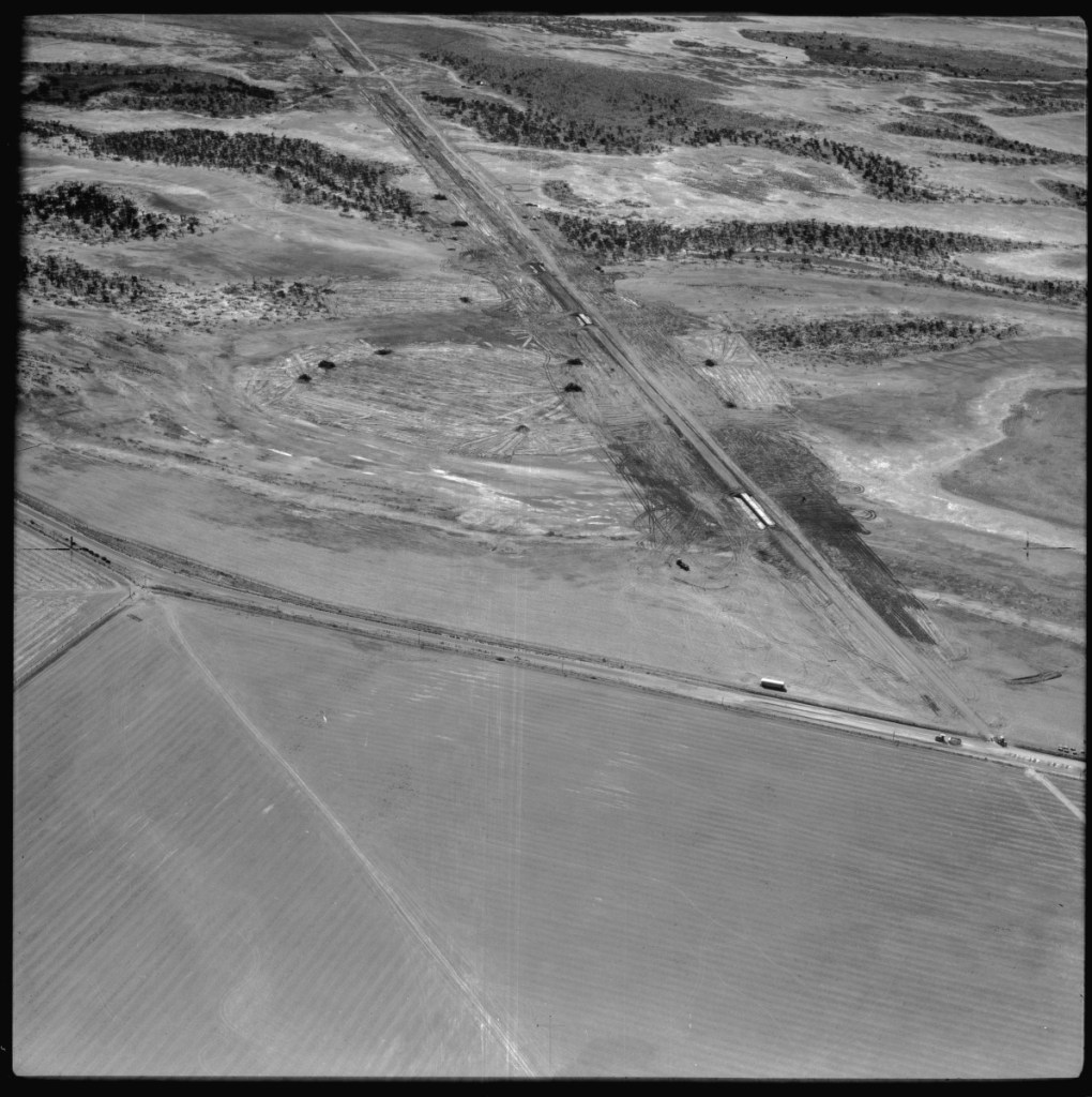
- State Library of Western Australia (n.d.) Aerial Surveys Australia : collection of aerial photographs of Western Australia; BA1475/5993-5994. Retrieved 20 Feb 2026 from https://encore.slwa.wa.gov.au/iii/encore/record/C__Rb2408031 ↩︎
- mindat.org (n.d.) Baandee, Merredin, State of Western Australia, Australia. Retrieved 20 Feb 2026 from https://www.mindat.org/feature-2077434.html ↩︎
- Travel Nut (n.d.) Baandee Lake. Retrieved 20 Feb 2026 from https://travel-nut.com.au/wheatbelt/baandee-lake/ ↩︎
- Central Wheatbelt Visitor Centre (n.d.) Baandee Lake. Retrieved 20 Feb 2026 from https://www.wheatbelttourism.com/granite-outcrops-salt-lakes/baandee-lake/ ↩︎
- State Records Office of WA (2015). Baandee Tally Sheets. Retrieved 20 Feb 2026 from https://archive.sro.wa.gov.au/index.php/informationobject/browse?topLod=0&query=Baandee&onlyMedia=1 ↩︎
