Christine Harris (2026)
Demographics
Region: Wheatbelt
LGA: Yilgarn
Industry: Mining and Agriculture
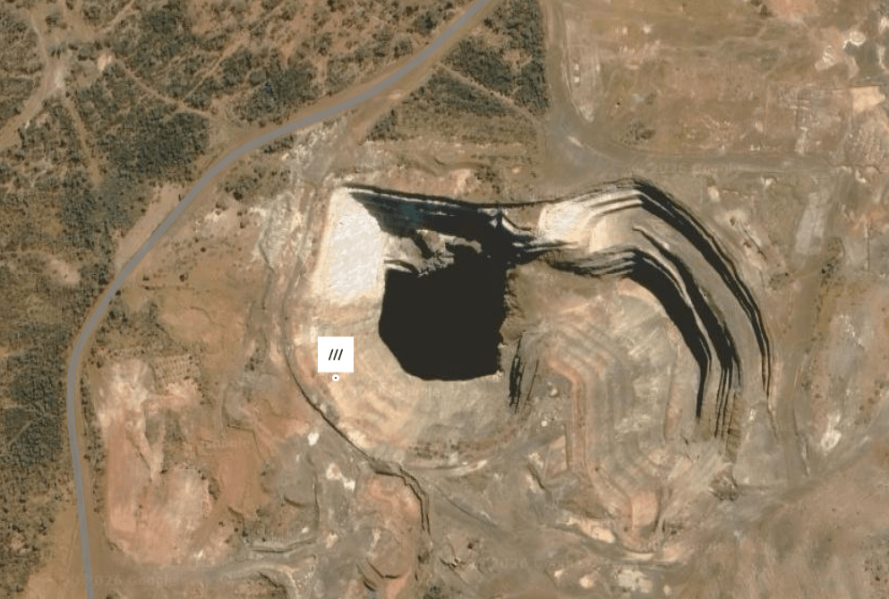
Open Street Map: -31.54327870003353, 119.57261960051912
What3Words: ///weeknights.grail.perceptive
Settled: About 1916
Gazetted: N/A
Abandoned: About 1943
Abstract
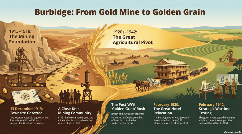
Burbidge, located in the Yilgarn Shire of Western Australia, represents a unique chapter in the state’s mining and agricultural development. Situated within the Forrestania Nickel Metallogenic Province, the town was born from the success of the Great Victoria Gold Mine and named in honour of its discoverer. Gazetted in 1913, the townsite was designed to provide a structured home for miners and their families working the ancient, mineral-rich rocks of the Yilgarn Craton. However, daily life was defined by a harsh, cold semi-arid climate where water scarcity was a constant threat to both residents and industry.
The 1920s marked a pivotal economic and political shift as the British and Australian governments launched a massive settlement scheme to transform the Yilgarn bush into productive wheat farms. This initiative, which offered land and free passage to returned soldiers, triggered a “second rush” for grain that ultimately eclipsed the local mining industry. The relocation of the substantial Burbidge Hotel to the agricultural hub of Moorine Rock in 1930 symbolised the community’s transition from a mining hub to a support locality for broad-acre farming. Despite its residential decline, Burbidge maintained strategic importance during World War II through government-led sulphur exploration. Today, the area remains a site of immense geological interest, reflecting the complex interplay between environmental challenges, social endurance, and shifting economic priorities.
History
The history of Burbidge, situated within the Shire of Yilgarn, Western Australia, is a compelling narrative of human adaptation to a demanding environment and the strategic exploitation of the earth’s mineral wealth. Located at an elevation of 421 metres on the ancient Yilgarn Craton, the locality sits approximately 12 kilometres southeast of Marvel Loch. Its story is one of rapid growth followed by an inevitable transition as the economic focus of the region shifted from the depths of the gold mines to the expansive potential of the wheat belt.1 2 3
Discovery and the Birth of a Townsite
The foundation of the Burbidge community was intrinsically linked to the Great Victoria Gold Mine. Located a mere 0.1 kilometres north-northeast of the current Burbidge Mine site, the Great Victoria lode was the primary catalyst for settlement in the area. By the early 1910s, the productivity of the mine necessitated a formal townsite to replace the transient camps of early prospectors.
In December 1913, the Western Australian government gazetted a new townsite consisting of ninety-six lots. This new division was strategically laid out near the Great Victoria mine and was named “Burbidge” as a direct compliment to the prospector who had discovered the mine. The establishment of this town was a deliberate political and logistical act; the pre-existing “old townsite” was cancelled to make way for the more organised 1913 layout. Nineteen holders of business areas in the original division were transferred to the new townsite, with blocks allotted in the order they had been originally obtained. This transition signalled a shift towards a permanent commercial and social centre.4 5
Environmental Realities and Social Resilience
Life in Burbidge was dictated by the BSk Köppen climate type6, characterized as a cold semi-arid (steppe) climate. The landscape featured rugged bush dominated by rock types such as amphibolite, basalt, and ironstone. While geologically rich, containing minerals ranging from native gold to various garnets like almandine and andradite, the environment was unforgiving. Water was a precious commodity; even substantial stone breweries in the nearby district were abandoned because local wells were prone to going dry during the summer months.7 8
The social fabric of Burbidge was forged through shared challenges. In February 1918, the community’s resilience was tested when a young boy, Clarrie Bracegirdle, became lost in the scrub after a disagreement with a friend. The mine’s infrastructure played a vital role in the social safety net; the manager “incessantly blew the mine whistle” as a signal to the lost children. A search party was organized by 3:00 AM the following morning, venturing out into “bitter cold weather”. After enlisting a specialist tracker from Parker’s Range, the party found the boy, who had walked ten miles during his ordeal. Such events highlighted the close-knit nature of the community and their reliance on the mine as both an employer and a central point of communication.9
The 1920s Farming Scheme
The most significant turning point in the history of Burbidge occurred following World War I, driven by a grand political and economic vision. A plan was hatched between the British and Australian governments to transform a thousand square miles of Yilgarn bush into productive farms. This scheme, largely financed by the British government, offered free passage to ex-servicemen and their families to emigrate and take up land as a reward for their service.
By 1925, the region, previously defined by the rhythmic stamp of mining batteries, became a “hive of activity” as settlers busily cleared their blocks. This period was described locally as another “rush,” but this time for “golden grain rather than gold”. The impact of this shift was profound; demand for land in the area attracted many applicants, and by 1928, huge areas had been cleared for cultivation.
The government responded to this agricultural expansion with significant infrastructure projects. A properly formed road was constructed for 17 miles to service settlers south of Moorine Rock, and in June 1929, a telephone exchange was installed to connect 15 local farmers. The political focus had shifted so entirely that by June 1929, the annual meeting of Yilgarn ratepayers was held in the newly opened Moorine Public Hall – the first time such a meeting was conducted outside the regional centre of Southern Cross. In a display of pioneer cooperation, some settlers were even permitted to clear roads for 12 miles in lieu of paying rates that year.10
The Relocation of the Hotel
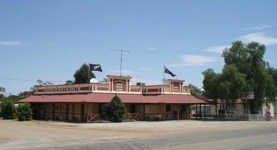
The physical decline of the Burbidge townsite was punctuated by a remarkable engineering feat in February 1930. As the population drifted toward the more prosperous farming districts, the community’s social hub, the Burbidge Hotel, followed them. The hotel was a substantial structure, boasting nine bedrooms, two sitting rooms, a bar, a billiard room, and motor accommodation.
To save the building, it was “jinkered” (transported on heavy-duty trailers) 22 kilometres west to the townsite of Moorine Rock. The relocation of the pub marked the symbolic end of Burbidge as a bustling town. While the Great Victoria mine continued to be a landmark, the social and commercial energy of the district was now firmly anchored in the farming communities of Moorine Rock, Dulyalbin, and Mount Hampton.11
War, Politics, and Strategic Minerals
Despite the decline of its residential population, the Burbidge Mine remained an asset of strategic importance, particularly during the global crisis of World War II. In February 1942, the Western Australian Government undertook boring operations on the Burbidge Gold Mines, N.L. lease to test the sulphur content of the Great Victoria lode. This was a critical political intervention; the government specified that if the sulphur content was high enough, the mine might be required to be worked specifically for smelting sulphur to aid the war effort.13
The war also saw the temporary repurposing of the district’s infrastructure. The Moorine Rock Hotel, which had been moved from Burbidge in 1930, closed as a pub and became a temporary convent for the Highgate Convent School, providing a safe haven for students from Perth who were relocated for their safety.14
Legacy and Modern Context
Following the war, the district experienced further changes as farms grew larger and machinery enabled broad-acre farming to become the norm. This led to a gradual reduction in population, though the Moorine Rock and Dulyalbin districts remain among the most prosperous in the Yilgarn.15
The site of the Burbidge Mine itself remains a significant geological locality within the Forrestania Nickel Metallogenic Province. It is a place where modern researchers still document a vast array of minerals, including scheelite, maldonite, and pyrrhotite. The community of Burbidge may have faded as a residential townsite, but its history reflects the broader Western Australian story: a relentless cycle of mineral discovery, environmental struggle, and the eventual taming of the bush for the “golden grain” of the wheat belt.
Timeline
- 1892: Telegraph line constructed between York and Southern Cross, passing through “13-mile” (later Moorine Rock).
- Late 1800s/Early 1900s: Discovery of the Great Victoria Gold Mine by prospector Burbidge.
- December 1913: The Burbidge townsite is officially gazetted with 96 lots; the original “old townsite” is cancelled.
- February 1918: Clarrie Bracegirdle is lost in the bush; a search party is launched following signals from the mine whistle.
- Post-WWI (Early 1920s): British and Australian governments launch the Yilgarn farming scheme for returned soldiers.
- 1925: The district becomes a “hive of activity” with settlers clearing land for grain.
- October 1926: The townsite of Moorine Rock is gazetted and renamed from Parkers Road to avoid mail confusion.
- June 1929: Official opening of the Moorine Public Hall.
- February 1930: The Burbidge Hotel is “jinkered” from Burbidge to Moorine Rock.
- October 1931: A second well is opened at Dulyalbin Rock to combat water scarcity for local farmers.
- February 1942: The Western Australian Government tests the Great Victoria lode for its sulphur smelting potential.
- 1940s (WWII): The Moorine Rock Hotel serves as a temporary convent for Perth students.
- Modern Era: Broad-acre farming becomes the norm in the Yilgarn; Burbidge Mine remains a key geological site.
Map
Sources
- Mapcarta (2026). Burbidge Mine. Retrieved 25 Feb 2026 from https://mapcarta.com/28820648 ↩︎
- mindat.org (2026). Burbidge Mine, Yilgarn, State of Western Australia, Australia. Retrieved 25 Feb 2026 from https://www.mindat.org/feature-8237485.html ↩︎
- Shire of Yilgarn (2026). Moorine Rock (town site). Retrieved 25 Feb 2026 from https://visit.yilgarn.wa.gov.au/towns/moorine-rock.aspx ↩︎
- BURBIDGE. (1913, December 10). The Southern Cross Times (WA : 1900 – 1920), p. 2. Retrieved February 25, 2026, from http://nla.gov.au/nla.news-article209345499 ↩︎
- mindat: refers to Great Victoria lode ↩︎
- BSk Köppen climate type indicates regions with low precipitation, hot summers and cold winters. ↩︎
- Shire of Yilgarn: refers to abandoned breweries ↩︎
- mindat: refers to geological and environmental factors ↩︎
- CHILD’S NIGHT IN THE BUSH (1918, February 19). Western Argus (Kalgoorlie, WA : 1916 – 1938), p. 13. Retrieved February 25, 2026, from http://nla.gov.au/nla.news-article34182253 ↩︎
- Shire of Yilgarn: refers to post war development ↩︎
- ibid: refers to relocation of hotel ↩︎
- Shire of Yilgarn (2025). Accommodation: Moorine Rock Hotel. Retrieved 25 Feb 2026 from https://visit.yilgarn.wa.gov.au/accommodation/hotels-and-motels/moorine-rock-hotel.aspx ↩︎
- BURBIDGE GOLD MINES (1942, February 23). Daily Mirror (Sydney, NSW : 1941 – 1955), p. 14 (Country Edition). Retrieved February 25, 2026, from http://nla.gov.au/nla.news-article272103360 ↩︎
- Shire of Yilgarn, 2026: refers to use of hotel for evacuees ↩︎
- ibid: refers to post WWII changes ↩︎
- what3words.com (2026). Burbidge. Retrieved 26 Feb 2026 from https://what3words.com/weeknights.grail.perceptive ↩︎
