Christine Harris, 2026
Demographics
Region: Wheatbelt
LGA: Yilgarn
Industry: Mining
Other Names: Knutsford, Colreavy, Cordelia
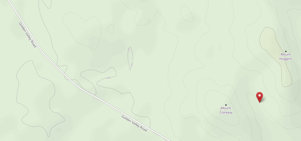
Open Street Map: -30.886111399526424, 119.02662853276283
What3Words: ///defied.expired.dislodge
Settled: 1887
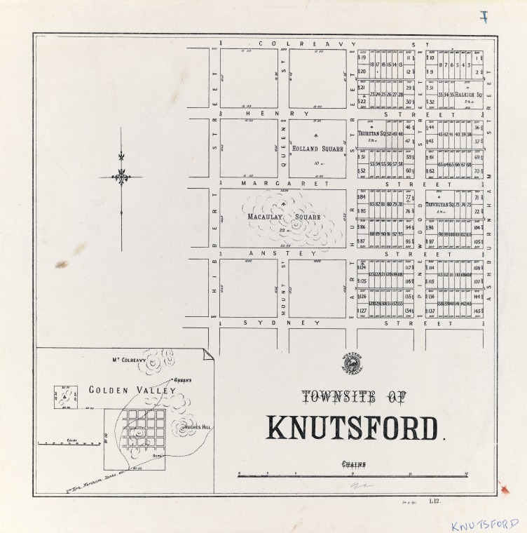
Gazetted: 1889 as Knutsford
Abandoned: 1903
Abstract
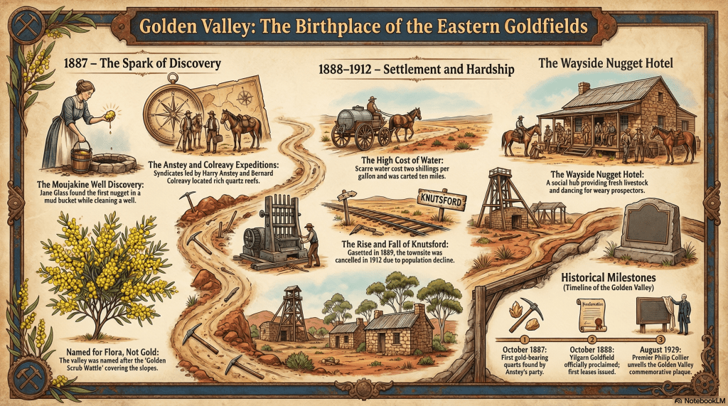
This article explores the storied past of Golden Valley, the first official centre of the Shire of Yilgarn and the spark for the Eastern Goldfields rushes. Ironically named after the “Golden Scrub Wattle” that blankets its slopes, the valley’s history began in early 1887 when Jane Mary Glass discovered a gold nugget while cleaning a station well at Mujakine. This accidental find launched a series of prospecting expeditions, most notably by the parties of Harry Anstey and Bernard Norbert Colreavy. Colreavy’s discovery of the Kathleen reef in December 1887 established the region’s first mining lease and paved the way for the development of Southern Cross and later Coolgardie.
The narrative details the immense hardships faced by pioneers, specifically the environment factors of “putrid” water that cost two shillings a gallon and left many, including prospector Dick Greaves, with lifelong health issues. It chronicles the rise of the township of Knutsford and its social heart, the Wayside Nugget Hotel, which hosted lively “parties and race meetings” under the management of families like the Farrens and the Paynes. Finally, the article reflects on the town’s decline as gold “pinched out” at depth, leading to Knutsford’s cancellation in 1912. Today, Golden Valley is a reserved national monument where the remnants of a hand-hewn tunnel and a lone granite cottage stand as silent witnesses to its brief, bright era.
History
Tucked away approximately 10 kilometres north of Bullfinch lies a quiet reserve that once pulsed with the fevered hopes of thousands. Golden Valley, the historic birthplace of the Yilgarn gold rush, carries a name that is frequently misunderstood. While many assume it refers to the riches beneath the soil, it was actually named for the Golden Scrub Wattle that illuminates the valley’s slopes.1 2 3
A Possum and a Prospect
The story of the valley began not with a professional miner, but with a housewife at Mujakine station. In early 1887, Mrs Jane Mary Glass discovered a drowned possum in her well. When her son, Alex, climbed down to clean the mud out, Jane hauled up a bucket and spotted the unmistakable glint of a gold nugget. This serendipitous discovery prompted the Newcastle and Northam Settlers Association to commission prospectors to examine the area.4 5
By late 1887, two rival parties were scouring the Yilgarn Hills. The first, led by Harry Francis Anstey, included Dick Greaves and Ted Payne. Shortly after, Bernard Norbert Colreavy arrived on the scene. Though Anstey’s party found gold at Eenuin, it was Colreavy who discovered the Kathleen reef (initially named ‘Cordelia’ by Greaves) in Golden Valley on 30 December 1887. This discovery led to the registration of the first gold mining lease on the Eastern Goldfields in 1888.6 7
Life in Knutsford
The township of Knutsford was gazetted in the valley in April 1890, though locals rarely used the name, preferring the wattle-inspired original. Life for the “hopefuls” who flocked there was defined by a brutal lack of water. Water had to be carted from 10 miles away, costing a staggering two shillings per gallon. Much of the available water was “putrid,” causing prospectors like Dick Greaves to suffer from typhoid fever and hydatids.8 9
The social centre of the community was the Wayside Nugget Hotel. First licensed to a Mr Agreen in 1888, it was soon purchased by Thomas Farren. The hotel provided a rare luxury: fresh food. Farren introduced pigs, goats, and poultry to supplement a monotonous diet of kangaroo, wild turkey, and mallee hen. Genealogy enthusiasts may be interested to know that Mrs Farren once had to travel 200 miles in a rough buckboard buggy just to reach a hospital to give birth to her fourth child.11 12
In 1894, the hotel passed to Joseph Payne, who arrived from Victoria with his wife, one son, and seven daughters. The Paynes were famous for their hospitality, often pushing back tables and chairs for dancing that lasted well into the night. However, tragedy struck when Joseph was kicked in the head by a horse in Southern Cross and died, leaving his widow and five remaining daughters to run the 50,000-acre station and hotel alone.13 14
The Aboriginal Context
Aboriginal guides played a crucial, though often under-recognised, role in the town’s survival. In November 1887, a guide named Phillip saved the lives of Greaves and Payne after they had gone 63 hours without water by feeding them “Nager root” and bardie grubs. While early interactions were largely driven by Aboriginal interest in European tools like tomahawks, the rapid expansion of European water works eventually disrupted traditional movement patterns.15
Legacy
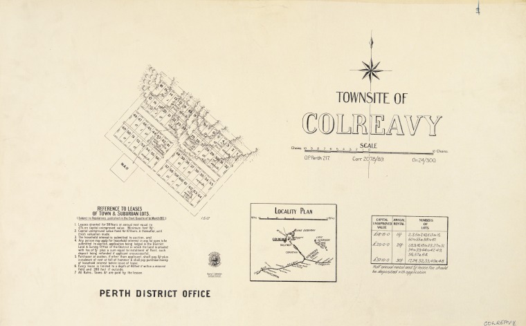
Golden Valley was “no bonanza”. The gold reefs “pinched out” at depth, discouraging large company developments. By the 1903 census, the town’s decline was evident; the population consisted of five women and nil men. In 1912, the township of Knutsford was officially cancelled and a new townsite, Colreavy, was gazetted close by.16
One of the last notable figures was Wally Booker, a grano worker who built a small one-room cottage from smooth granite slabs. He operated a five-stamp battery in the valley for decades. In a final tribute to the land he worked, Booker’s ashes were scattered amongst the tailings near his cottage. Today, the site is a national monument held in trust by the Royal Western Australian Historical Society, marking the spot where Western Australia’s golden destiny truly began.18
Timeline
- Early 1887: Jane Mary Glass discovers a gold nugget in a well at Mujakine station.
- July 1887: A prospecting syndicate (Greaves, Payne, and Anstey) leaves Perth for the Yilgarn.
- October 1887: Anstey’s party discovers gold-bearing quartz at Eenuin.
- 30 December 1887: Bernard Norbert Colreavy discovers the Kathleen reef in Golden Valley.
- 12 January 1888: H. Huggins discovers a second gold reef nearby.
- July 1888: A post office is established in Golden Valley (Knutsford).
- 1 October 1888: The Yilgarn Goldfield is officially proclaimed.
- 11 October 1888: Warden A. Thompson arrives at Golden Valley to begin local administration.
- December 1888: A police camp is formed at Golden Valley under Sergeant Connell.
- May 1889: Government officials and police relocate from Golden Valley to Southern Cross.
- January 1890: The Golden Valley Post Office is officially moved to Southern Cross.
- April 1890: The township of Knutsford is formally gazetted.
- 1894: Joseph Payne takes over the Wayside Nugget Hotel and its 50,000-acre station.
- 1912: The township of Knutsford is cancelled; the townsite of Colreavy is gazetted 1,400 metres north.
- 17 August 1929: A memorial plaque is unveiled by Premier Phillip Collier to honour the first mining lease.
Map
Sources
- Hudson Institute of Mineralogy (2025) Golden Valley gold area, Bullfinch, Yilgarn Shire, Western Australia, Australia. Retrieved 27 Mar 2026 from https://www.mindat.org/loc-266597.html ↩︎
- Tourism WA (n.d.) Golden Valley. Retrieved 27 Mar 2026 from https://www.australiasgoldenoutback.com/products/golden-valley ↩︎
- The Club Hotel (n.d.) Golden Valley, Knutsford. Retrieved 27 Mar 2026 from https://www.clubhotel.com.au/golden-valley-knutsford/ ↩︎
- Sharp, Moya (2016) Golden Valley – The Early Days. Retrieved 27 Mar 2026 from https://www.outbackfamilyhistoryblog.com/golden-valley-by-kevin-moran/ ↩︎
- Explorers’ Wells and Tracks Project (n.d.) White Man Rock Well. Retrieved 27 Mar 2026 from https://wellsandtracks.com.au/wells/pioneer-wells/white-man-rock-well/ ↩︎
- Wikipedia (2021) Australian Gold Rushes. Retrieved 27 Mar 2026 from https://en.wikipedia.org/wiki/Australian_gold_rushes ↩︎
- Shire of Yilgarn (n.d.) Golden Valley: Township of Knutsford. PDF brochure retrieved 27 Mar 2026 from https://visit.yilgarn.wa.gov.au/Profiles/visit/Assets/ClientData/Documents/New_Brochures/Golden_Valley.pdf ↩︎
- Colonial Secretary WA (1890) Proclamation in the Government Gazette of Western Australia. No.16 of 1890. Perth: Thursday, April 3. Retrieved 27 Mar 2026 from https://www.legislation.wa.gov.au/legislation/prod/gazettestore.nsf/FileURL/gg1890_016.pdf/$FILE/Gg1890_016.pdf?OpenElement ↩︎
- MR. RICHARD GREAVES. (1896, July 18). Geraldton Murchison Telegraph (WA : 1892 – 1899), p. 2. Retrieved March 27, 2026, from http://nla.gov.au/nla.news-article260160019 ↩︎
- State Library of Western Australia (n.d.) Townsite Maps, Western Australia. Retrieved 27 Mar 2026 from https://encore.slwa.wa.gov.au/iii/encore/record/C__Rb1922423 ↩︎
- Shire of Yilgarn (n.d.) Golden Valley. Retrieved 27 Mar 2026 from https://visit.yilgarn.wa.gov.au/see-do/historic/golden-valley.aspx ↩︎
- Shire of Yilgarn (n.d.) Golden Valley: Township of Knutsford. PDF brochure retrieved 27 Mar 2026 from https://visit.yilgarn.wa.gov.au/Profiles/visit/Assets/ClientData/Documents/New_Brochures/Golden_Valley.pdf ↩︎
- Wrigley, Matthew (2023). Water in the context of colonisation in the Goldfields. Retrieved 27 Mar 2026 from https://wangka.com.au/wp-content/uploads/2023/11/Water-in-the-Context-of-Colinisation-in-the-Goldfields-Matt-Wrigley.pdf ↩︎
- Sharp, Moya (n.d.) Colreavy / Golden Valley Western Australia. Retrieved 27 Mar 2026 from https://www.outbackfamilyhistory.com.au/records/record.php?record_id=768 ↩︎
- State Library of Western Australia (n.d.) Townsite Maps, Western Australia. Retrieved 27 Mar 2026 from https://encore.slwa.wa.gov.au/iii/encore/record/C__Rb1879192 ↩︎
- Hudson Institute: refers to decreased gold grades ↩︎
- Open Street Map (2026) Golden Valley. Retrieved 27 Mar 2026 from https://www.openstreetmap.org/search?query=+-30.886111399526424%2C+119.02662853276283&zoom=18&minlon=121.06121957302095&minlat=-30.684914818271764&maxlon=121.07151925563814&maxlat=-30.680965728795147#map=16/-30.88447/119.01788&layers=C ↩︎
Further Reading
- Early Days of Yilgarn District. Edited by Peter J Bridge and Angela Teague. ISBN 978 85905 445 4
