Christine Harris (2026)
Demographics
Region: South West
LGA: Augusta-Margaret River
Industry: Group Settlement; Farming, Timber & Railway
Other Names: Coodardup, Koodardup Mill, Kudardup Mill, Coodardup Caves, Group 3, Group 4
Open Street Map: -34.24908, 115.15518
What3Words: ///glosses.handled.sipped
Settled: 1883
Gazetted: 1957
Population: 2016 – 241; 2021 – 110
Abstract
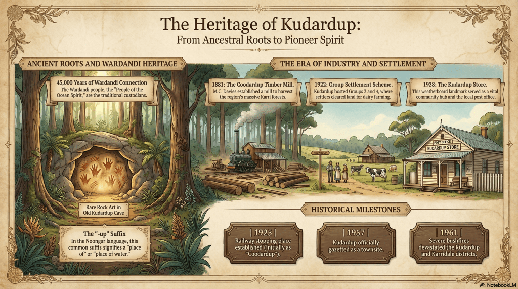
This article explores the multi-faceted history of Kudardup, a locality situated in the Shire of Augusta-Margaret River, Western Australia. The narrative begins with the traditional custodians, the Wardandi people, and the significant discovery of ancient hand stencils in the Old Kudardup Cave, which represent the first recorded painted rock art in a south-western limestone cave. The focus then shifts to the 1880s, an era dominated by the “Timber Tycoon” Maurice Coleman Davies. Davies established the Koodardup Mill in 1881, a massive operation that kickstarted the region’s timber industry and necessitated the construction of an intricate private railway system and jetties at Hamelin and Flinders Bays.
Following the decline of the timber boom, the article examines the social experiment of the Group Settlement Scheme in the 1920s. Kudardup was the site of Groups 3 and 4, where largely inexperienced British migrants struggled to establish dairy farms in the formidable karri forests. The article details the economic impact of the 1925 Flinders Bay branch railway and the subsequent growth of local commerce, highlighted by the establishment of the Kudardup Store and Hall. Finally, it covers the challenges of the post-war era, including the War Service Land Settlement Scheme and the catastrophic 1961 bushfires that reshaped the community, concluding with Kudardup’s modern identity and the preservation of its heritage through the Wadandi Track.
History
The history of the area now known as Kudardup begins more than 45,000 years ago with the Wardandi people, the traditional custodians of the land. The name Wardandi translates to “people of the sea,” reflecting an Ocean Spirit and a deep affinity with the coastal environment. For these First Australians, the local landscape was a well-watered forest-heath environment that provided abundant resources for hunter-gatherers, including wallaby, kangaroo, possum, and shellfish. The Wardandi people held a spiritual connection to the limestone caves along the Leeuwin-Naturaliste Ridge, believing these sites were conduits to the afterlife. In November 1982, amateur speleologists confirmed the depth of this connection when they discovered two Aboriginal painted hand stencils in the Old Kudardup Cave, roughly 6 km north-west of Augusta. These stencils, made in reddish-brown ochre, represent the first record of painted rock art in a south-western Australian limestone cave. Archaeological evidence, including fossiliferous chert artifacts1, suggests the cave was visited as far back as the Late Pleistocene or Middle Holocene eras.2 3 4
M.C. Davies and the Timber Empire (1875–1913)
The modern industrial history of Kudardup was forged by the ambition of Maurice Coleman Davies, an Adelaide-based contractor who visited Western Australia in 1875 to inspect its timber potential. Recognising that successful milling required a good harbour and reliable transport, Davies purchased a lease to cut timber at “Coodardup” (as it was then spelt) in 1878. In 1881, he established the Koodardup Mill to exploit the nearby karri forests. This was a substantial enterprise, employing one hundred workers and operating around the clock with circular, vertical, and crosscut saws.5 6
To move the massive logs, Davies commenced laying a wooden tramline from Coodardup to the winter port of Flinders Bay and the summer port of Hamelin Bay.7 By 1882, work had begun on a substantial jetty at Flinders Bay, which was eventually connected by a steel 3’6″ gauge railway to Karridale. While the Coodardup Mill was relocated to Karridale in 1882 to double its capacity, the Kudardup area remained a vital component of Davies’ vast timber network. This network was so efficient that Western Australian karri blocks from the region were eventually used to pave the streets of London, including Pall Mall and Piccadilly.8 9 10
During this early industrial period, life in the mill camps was arduous but socially vibrant. One local story involves the notorious Joseph Bolitho Johns, better known as “Moondyne Joe,” who was employed at the Coodardup mills while they were operated by Millars Timber and Trading Co. It is recorded that as a joke, the mill hands once put the famous bushranger down a local cave and left him there for a period, perhaps adding a humorous chapter to the legend of Western Australia’s most prolific escape artist. This cave, nearby and historically recorded as “Coodardup Caves,” later became known as the Coronation Cave or “Cauliflower Cave” due to its unique crystal formations.11
The Struggle of the Group Settlement Scheme
The timber boom declined by 1914, and Kudardup was largely abandoned until the early 1920s when it became a focal point of the Group Settlement Scheme. Engineered by Premier James Mitchell, nicknamed “Moo-Cow” for his obsession with the dairy industry, the scheme aimed to clear large tracts of forest to make the state self-sufficient in food production. Kudardup was designated as the location for Groups 3 and 4.12 13 14 15
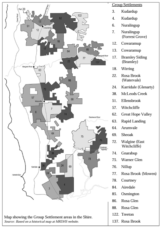
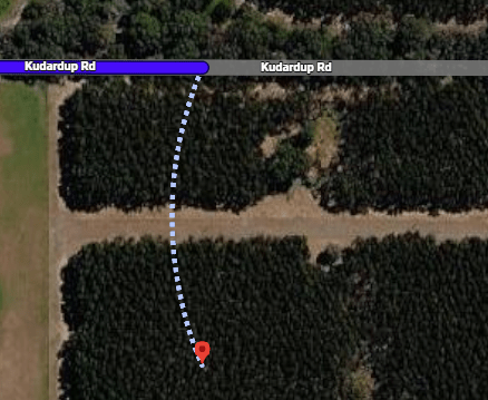
Groups 3 and 4 are at the bottom of the map16
Settlers, primarily British migrants fleeing post-war unemployment, arrived in waves between 1922 and 1929. These families were often misled by propaganda promising a land of “opportunity and plenty,” only to find themselves isolated in “virgin forests” with inadequate resources. Upon arrival, families lived in “humpies” (temporary shelters made of tin and timber slabs with earthen floors) while the men worked under foremen to clear 25 acres of heavily timbered land. Only after the land was cleared and fenced were the characteristic four-roomed weatherboard cottages erected.17 18
The hardship was extreme. Many settlers had no farming experience and were supplied with unsuitable equipment to tackle the immense hardwood forests. Socially, however, the “groupies” developed a remarkable sense of solidarity. Local schools, typically weatherboard and asbestos structures with removable dividing walls, served as the heart of social life, doubling as halls for dances, church services, and Special occasions. In Kudardup, a memorial plaque now stands at the corner of Bussell Highway and Fisher Road to commemorate the resilience of these early dairy pioneers.19
The Coming of the Railway and Commercial Growth
A major economic turning point occurred in 1925 when the Flinders Bay branch railway was officially opened, linking Margaret River to Flinders Bay. Kudardup was established as a stopping place on this line, and in 1926, the spelling of the locality was officially changed from “Coodardup” to its current form. The railway was essential for the fledgling dairy industry, allowing farmers to transport cream to the factory in Margaret River for processing.20 21 22
Commerce followed the rail line. The Kudardup Store was constructed around 1928 and run by Mr and Mrs Hillier, who also operated the local postal service. The store, a rectangular weatherboard building with a gabled Colorbond roof, stands today as one of the few surviving examples of the local stores established to serve the Group Settlements. The Hilliers were staples of the community for two decades until their retirement in 1948. Nearby, the Kudardup Hall was erected, possibly between 1929 and 1935, on land reserved for public buildings. Though some secondary accounts suggest it was used as a tobacco shed, its primary role was as a community centre, and from 1956 to 2002, it served as a meeting venue for the Country Women’s Association (CWA).23 24
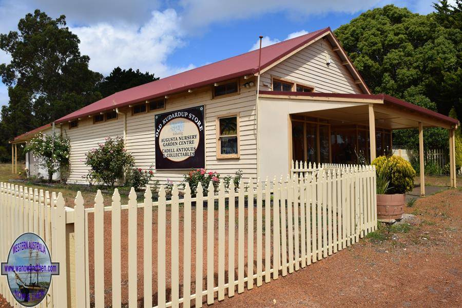
(now the Augusta Nursery & Cadell Antiques)
Local Families
For those researching family histories, Kudardup’s records are rich with the names of those who shaped the district. Early pioneers included the Allnutt family, with Frank Allnutt being a member of a prominent South West pioneer family. The Layman family of Wonnerup House also had early connections to the area. Livestock brand records from 1962 list numerous families who remained in Kudardup long after the initial settlement schemes, including the Challis, Chapman, Cooper, Fowler, Gale, Gray, Hall, Hollingsworth, Holman, Hough, Jeffrey, Jones, Markham, McManus, Merritt, Murphy, O’Sullivan, Ogden, Overton, Pettit, Phillips, Pratt, Price, Rafferty, Sorensen, Tichborne, and Vansittart families.26
The local school also provides a genealogical trail through its list of headmasters and teachers. Notable names include George R. Jones (1923), Stacey Turner and Ada Hillier (1926), Richard Greep (1927), Stephen Wallace (1931), John and Lucy Brennan (1936), Wm. Crouchley (1940), Florence Payne (1943), Kenneth Rolfe (1946), Lawrence Phillips (1949), Stanley Hughes (1953), Laurence Barker (1955), Richard Anthony (1958), and William Gaynor (1966).27
World War II and the War Service Scheme
The outbreak of World War II again saw the young men of Kudardup enlist for service. The resulting labour shortage on local farms was partly addressed by the arrival of Italian Prisoners of War in 1943, who worked as farm labourers throughout the district. The war also prompted agricultural diversification, such as exploratory tobacco crops established from Cowaramup through to Karridale.
Post-war, the War Service Land Settlement Scheme (WSLSS) was introduced to accommodate returning soldiers. This scheme was generally more successful than the earlier Group Settlement, as it involved acquiring abandoned blocks and using organised parties of workmen to upgrade clearings, renew fences, and establish viable pastures. This era saw an increase in dairy production and a new wave of migration that bolstered the local population.28
The 1961 Bushfires and the End of an Era
Environmental factors have often dictated the pace of Kudardup’s development. The most catastrophic of these was the Great Bushfire of March 1961. These fires raged for 41 days, destroying over 40,000 hectares of farms and forest between Margaret River and Augusta. Kudardup was devastated, and the old timber settlements at Karridale were virtually wiped out. During the crisis, Kudardup’s school children were evacuated to Augusta, where they were cared for by local residents. This event remains a defining moment of communal trauma and resilience for the district.29
The mid-20th century also saw the decline of the railway. As road transport became more viable and the Bussell Highway was sealed between 1947 and 1954, the Flinders Bay branch line became unviable. The line officially closed on 1 July 1957, the same year Kudardup was officially gazetted as a townsite.30 31
Modern Kudardup and the Wadandi Track
Today, Kudardup remains a small but proud locality. In the 2016 Census, the population was recorded at 99 people, with a median age of 47. By 2021, the population had slightly increased to 110. The old Kudardup Store, though vacant in recent years, has previously served as a cabinet maker’s shop, a nursery, an antiques & collectibles emporium and a recycled clothing store. The legacy of the railway survives in the form of the Wadandi Track, a recreational rail trail for bushwalkers and cyclists that takes its name from the area’s first people.32 33 34
From the ancient ochre stencils in its caves to the steam whistles of M.C. Davies’ locomotives and the hard-won “cream cheques” of the group settlers, Kudardup’s history is a testament to the enduring relationship between people and the land in Western Australia’s South West.
Timeline
- Pre-European Settlement: The Wardandi people inhabit the region for over 45,000 years, using caves for spiritual and practical purposes.
- 1622: The Dutch ship Leeuwin maps the coastline, naming the area “t Landt van de Leeuwin”.
- 1848: First recorded discovery of a cave in the region, believed to be the Old Kudardup Cave.
- 1878: Maurice Coleman Davies purchases a timber lease for the Coodardup area.
- c. 1880: Construction begins on a wooden tramline from Coodardup to Flinders Bay.
- 1881: Davies establishes the Koodardup Mill, employing 100 workers.
- 1882: The Coodardup Mill is moved to Karridale to expand capacity; work starts on the Flinders Bay jetty.
- 1885: Flinders Bay is connected to Karridale by a steel railway.
- 1902: M.C. Davies’ operations are amalgamated into Millars’ Karri and Jarrah Co..
- 1913: Millars’ timber concession expires; the local mills and railway are closed.
- 1921/22: Kudardup becomes part of the Group Settlement Scheme (Groups 3 and 4).
- 1924: The first Kudardup School teacher, George R. Jones, is appointed.
- 1925: The Western Australian Government Railways (WAGR) line from Margaret River to Flinders Bay officially opens.
- 1926: The locality name is officially changed from “Coodardup” to “Kudardup”.
- c. 1928: The Kudardup Store is built and operated by the Hillier family.
- 1930s: High levels of dairy production begin as Group Settlement farms become viable.
- 1943: Italian Prisoners of War are used as farm labourers in the district.
- c. 1946: A fire occurs at the Kudardup Store.
- 1947–1954: The War Service Land Settlement Scheme consolidates local farming; Bussell Highway is sealed.
- 1954: Registration of the Kudardup Hall Association.
- 1956: The Kudardup Hall begins its 46-year tenure as a CWA meeting venue.
- 1957: The railway is closed; Kudardup is officially gazetted as a townsite.
- 1961: Major bushfires devastate Kudardup and surrounding districts.
- 1982: Ancient Aboriginal hand stencils are discovered in the Old Kudardup Cave.
- 2012: The Kudardup Store and Hall are formally identified for their heritage significance.
- 2013: The “Rails to Trails” project is formally named the Wadandi Track.
Map
Sources
- Fossiliferous chert is a hard, cryptocrystalline sedimentary rock composed of microcrystalline quartz (
) containing preserved remains of silica-secreting organisms, such as radiolarians, diatoms, and sponge spicules. It forms in marine environments through the accumulation of these siliceous skeletons, often replacing limestone, and is prized for its durability, conchoidal fracture, and sometimes high fossil content. ↩︎
- Green, Annette, Given, Carmel, and Carrick, Stephen (2012). Shire of Augusta-Margaret River Heritage Survey. p.12. Retrieved 7 Apr 2026 from https://www.amrshire.wa.gov.au/getmedia/189ee1cf-ce1a-4bfb-a1fc-80d04ed9ea3a/Heritage-Survey.pdf ↩︎
- Wikipedia (2024). Flinders Bay Railway Line. Retrieved 7 Apr 2026 from https://en.wikipedia.org/wiki/Flinders_Bay_railway_line ↩︎
- Morse, Kate (1984). First Record of Painted Aboriginal Rock Art in South-Western Australian Limestone Cave. in Records of the Western Australian Museum, Vol. 11(2):197-199. Retrieved 7 Apr 2026 from https://mrdhs.com.au/documents/aboriginal-art-kudardup-cave.pdf ↩︎
- Heritage Council of WA (2021). Inherit: Kudardup Store. Retrieved 7 Apr 2026 from https://inherit.dplh.wa.gov.au/public/inventory/printsinglerecord/ccd38a66-39ee-437c-a829-d7139914f634 ↩︎
- Green, et al: p.24, 48, & 83 ↩︎
- Charlton, Lorna and King, Rhianna (n.d.) Landscope: Stepback in time Jarrahdene. Retrieved 7 Apr 2026 from https://library.dbca.wa.gov.au/Journals/080052/080052-35.017.pdf ↩︎
- Wikipedia (2022). Kudardup, Western Australia. Retrieved 7 Apr 2026 from https://en.wikipedia.org/wiki/Kudardup,_Western_Australia ↩︎
- Green, et al: p.24-25, 84, & 142 ↩︎
- Heritage Council of WA (2021) Inherit: Flinders Bay Jetty. Retrieved 7 Apr 2026 from https://inherit.dplh.wa.gov.au/public/inventory/printsinglerecord/4706a2eb-8ecc-4dfa-9234-921b153a5b17 ↩︎
- Coronation Cave At Deepdene Has Been Sadly Neglected (1954, August 28). The West Australian (Perth, WA : 1879 – 1954), p. 25. Retrieved April 7, 2026, from http://nla.gov.au/nla.news-article49877005 ↩︎
- Heritage Council of WA (2021). Inherit: Kudardup Store. Retrieved 7 Apr 2026 from https://inherit.dplh.wa.gov.au/public/inventory/printsinglerecord/ccd38a66-39ee-437c-a829-d7139914f634 ↩︎
- Wikipedia (2024): refers to the War Service Land Settlement Scheme ↩︎
- Green, et al: p.23, 26, 40 & 58 ↩︎
- Wikipedia (2021). Group Settlement Scheme. Retrieved 7 Apr 2026 from https://en.wikipedia.org/wiki/Group_Settlement_Scheme ↩︎
- Green, et al: p.41 ↩︎
- Wikipedia (2021): refers to Group Settlement ↩︎
- Green, et al: p.42-45 ↩︎
- ibid: p.44-45, 79-80 ↩︎
- Higham, Geoffrey (2016) Back along the line. p.54. Retrieved 7 Apr 2026 from https://www.geoproject.com.au/News/Gaz_5_rail_ordered_08July2016.pdf ↩︎
- Green, et al: p.84 ↩︎
- Wikipedia (2024): refers to rail support industry ↩︎
- Heritage Council of Western Australia (2022). Inherit: Kudardup Hall. Retrieved 7 Apr 2026 from https://inherit.dplh.wa.gov.au/public/inventory/details/39944874-dd1a-4fd6-bb78-ce32132d7dca ↩︎
- WA Now and Then (n.d.) Kudardup. Retrieved 7 Apr 2026 from https://www.wanowandthen.com/Kudardup.html ↩︎
- ibid. ↩︎
- Carnamah Historical Society & Museum (n.d.) WA Livestock Brands 1912-1962. Retrieved 7 Apr 2026 from https://www.carnamah.com.au/livestock-brands?keyword=kudardup ↩︎
- ibid: WA State School Teachers 1900-1980. Retrieved 7 Apr 2026 from https://www.carnamah.com.au/teachers?keyword=Kudardup ↩︎
- Green, et al: p.45-50 ↩︎
- ibid: p.52-53 ↩︎
- ibid: p.338, 388-389 ↩︎
- Landgate (2022). Historical Town Names. Retrieved 7 Apr from https://web.archive.org/web/20220314101618/http://www0.landgate.wa.gov.au/maps-and-imagery/wa-geographic-names/name-history/historical-town-names ↩︎
- Australian Bureau of Statistics (2016). Census All Persons QuickStats: 2016 Kudardap. Retrieved 7 Apr 2026 from https://www.abs.gov.au/census/find-census-data/quickstats/2016/SSC50782 ↩︎
- ibid (2021): Census All Persons QuickStats: 2021 Kudardap. Retrieved 7 Apr 2026 from https://abs.gov.au/census/find-census-data/quickstats/2021/SAL50788 ↩︎
- Wikipedia (2024). Flinders Bay Railway Line. Retrieved 7 Apr 2026 from https://en.wikipedia.org/wiki/Flinders_Bay_railway_line ↩︎
Further Reading
- Everett, Valerie. Light in the distance. Available from SLWA on inter-library loan.
