Christine Harris (2026)
Demographics
Region: Goldfields-Esperance
LGA: Coolgardie
Industry: Gold mining
Other Names: Kunalling, 25 Mile, Coonanation, Coonalion, Coolalion, Connanalling
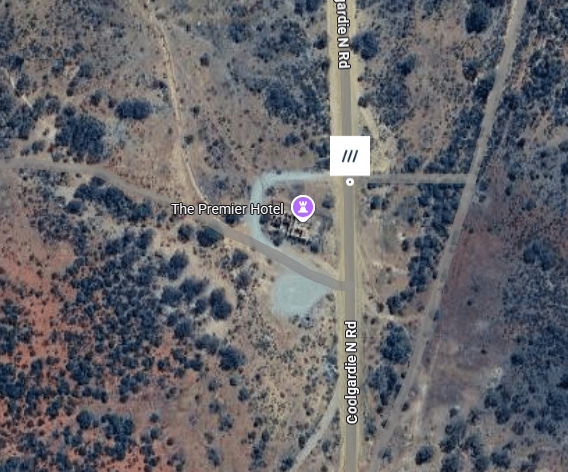
Open Street Map: -30.68294,121.06637
What3Words: ///drops.tingly.overreact
Settled: 1895
Gazetted: 1896
Abandoned: 1942
Abstract
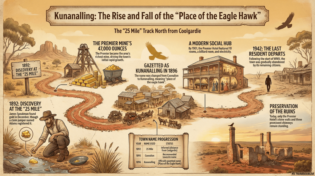
This article explores the history of Kunanalling, a now-abandoned goldfields town in Western Australia. Located approximately 32 kilometres north of Coolgardie, the site was initially established following the discovery of gold in December 1892 by James Speakman’s party. Known variously as the “25 Mile”, “Coonanalion”, and “Connanalling” before its official gazettal as Kunanalling, meaning “place of the eagle hawk”, the town became a focal point for the Eastern Goldfields’ economic expansion.
The narrative details the economic foundations of the town, primarily anchored by the Premier Gold Mine and the surrounding Kintore cement leases. It examines the social fabric of the community, highlighted by the “flash” Premier Hotel, which was among the first in the region to feature electricity and was renowned for the culinary innovations of its publican, “Gran” Kelly. Environmental challenges, specifically the chronic scarcity of water and timber, are analysed as critical factors that influenced the town’s development and eventual decline. Politically, the town demonstrated typical goldfields resilience, advocating for necessary infrastructure like banks and telegraph services against perceived government neglect. Following a brief resurgence in the 1930s, the town was gradually abandoned, with the last resident departing in 1942. Today, the crumbling ruins of the Premier Hotel serve as a poignant reminder for local historians and genealogists of a once-thriving community.
History
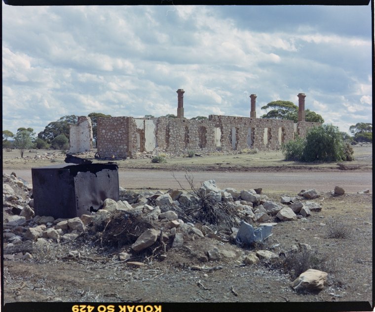
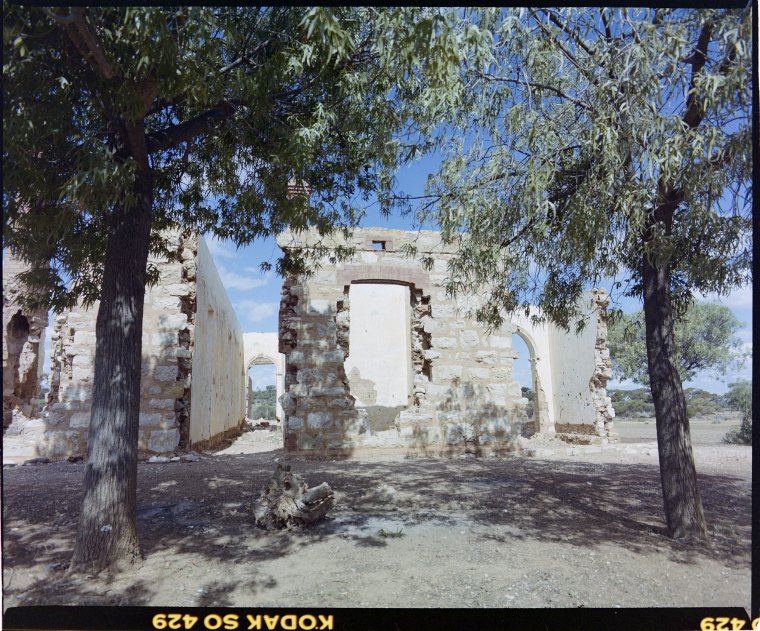
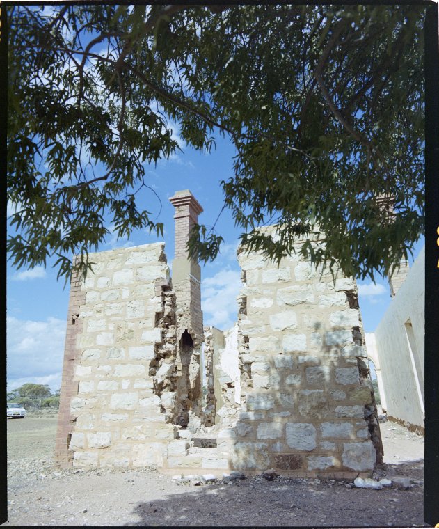
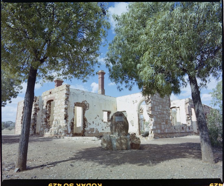
In the heart of the Western Australian goldfields, where the red earth meets the vast scrub of the Coolgardie district, lie the silent remnants of Kunanalling. To the modern traveller passing along the Coolgardie North Road, it is a landscape of “crumbling walls” and “prominent chimneys,” yet for the local historian and genealogist, these ruins whisper of a time when the “Place of the Eagle Hawk” was a bustling centre of hope and industry.1
What’s in a Name?
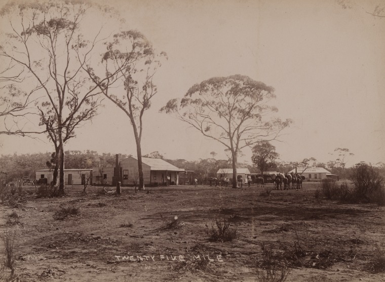
The nomenclature of the town reflects the practicalities and indigenous heritage of the region. Before it was officially christened Kunanalling, the locality was known simply as the “25 Mile,” a name derived from its estimated distance north of the Coolgardie township. However, the actual distance varied depending on the route taken; while the telegraph line marked it at just over 19 miles, the devious bush track used by coaches and teams made it approximately 22.5 miles.2 3 4 5
As the settlement grew, the postal and lands authorities sought more formal designations. For a period, the town was referred to as “Coonanalion,” “Coonalion,” or “Connanalling.” These variations often appeared on early date stamps and in government correspondence before the Lands Department applied standardised spelling rules. When the town was finally gazetted in 1896, the name Kunanalling was formalised. In the local Aboriginal dialect, this evocative name translates to the “place of the eagle hawk,” a fitting tribute to the birds of prey that still circle the silent ruins today.7 8 9
Gold Discovery
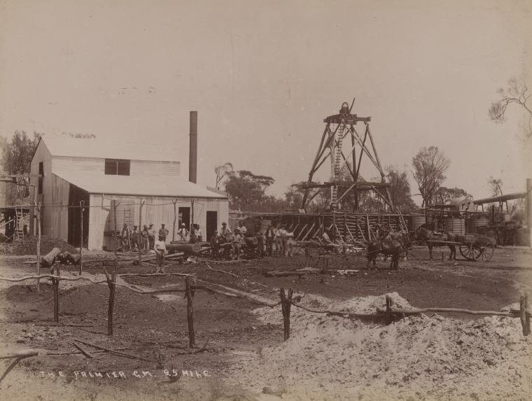
The genesis of Kunanalling is inextricably linked to the frantic gold rushes of the early 1890s. Gold was first discovered here in December 1892 by James Speakman and his party. In a cautionary tale for genealogists researching prospector ancestors, Speakman’s fortune was short-lived. He pegged a lease but failed to register it or apply for a water exemption before leaving the area. His claim was subsequently “jumped” by a man named Bill Adams, who registered the lease and sold it to a company that developed the famed Premier Gold Mine.10 11 12 13
The Premier Mine became the town’s economic backbone, eventually producing approximately 47,000 ounces of gold. By 1896, the mine was a significant operation with a ten-head battery, though development work was initially hampered by hard diorite country and broken lodes. Beyond the Premier, the district boasted several other “shows,” including the Blue Bell (originally known as the True Blue), Catherwood, and Inkerman mines.14 15 16
Economic life in Kunanalling was not solely focused on underground reefing. About seven miles north-westerly lay the Kintore group of cement leases. This “curious and interesting” deposit of conglomerate contained gold spread over an area roughly a mile square, resting on a granite bottom. By late 1896, companies like the Ormuz and the Great Dyke were systematically developing these surface deposits, employing stamp batteries and dry-crushing plants.18
The Battle for Water and Wood
The environment played a decisive, and often adversarial, role in Kunanalling’s history. Located in a “hot semi-arid” climate, the scarcity of water was a perennial threat to both human survival and industrial processing. To combat this, the Government constructed a massive water tank one mile south of the township, situated near large granite rocks to catch rainwater runoff—a technique established in the 1860s by explorer Charles Hunt.19 20 21
When the dam ran dry, residents relied on private wells and condensers that processed salty underground water, often sold at the high price of four to six pence per gallon. The salinity of the groundwater was so severe that it was often unsuitable for use in mining plants, further driving up operational costs. Similarly, the availability of timber—essential for fueling the steam-driven machinery and shoring up mine shafts—dwindled as the nearby Kalgoorlie mines reached full production, adding significant economic pressure to local ventures.22
Hotels, “Gran” Kelly, and Sunday Ice Cream
At its peak around 1898, Kunanalling’s population reached approximately 800 people. While the township itself was small, described in 1896 as a “small affair” of a few buildings, it served a large scattered population of miners residing on various leases. Social life centred on the town’s three hotels: the Royal, Friedlander’s (the 25-Mile Hotel), and most famously, the Premier Hotel.23 24
The Premier Hotel, built in 1901 by entrepreneur Fred “Cousin Jack” Bow, was a “flash” ten-bedroom establishment. It was notably one of the first in the goldfields to have electricity, provided by the nearby Premier Mine. For the genealogist, the stories of the people who ran these establishments are particularly vibrant. In the 1920s, the hotel was managed by “Gran” Kelly, who is credited with being one of the first publicans in Australia to offer counter meals in the bar. Her Sunday menu was a local legend, particularly her homemade ice cream, a rare luxury made using ice transported from the Kalgoorlie Ice Works and churned by hand.25 26
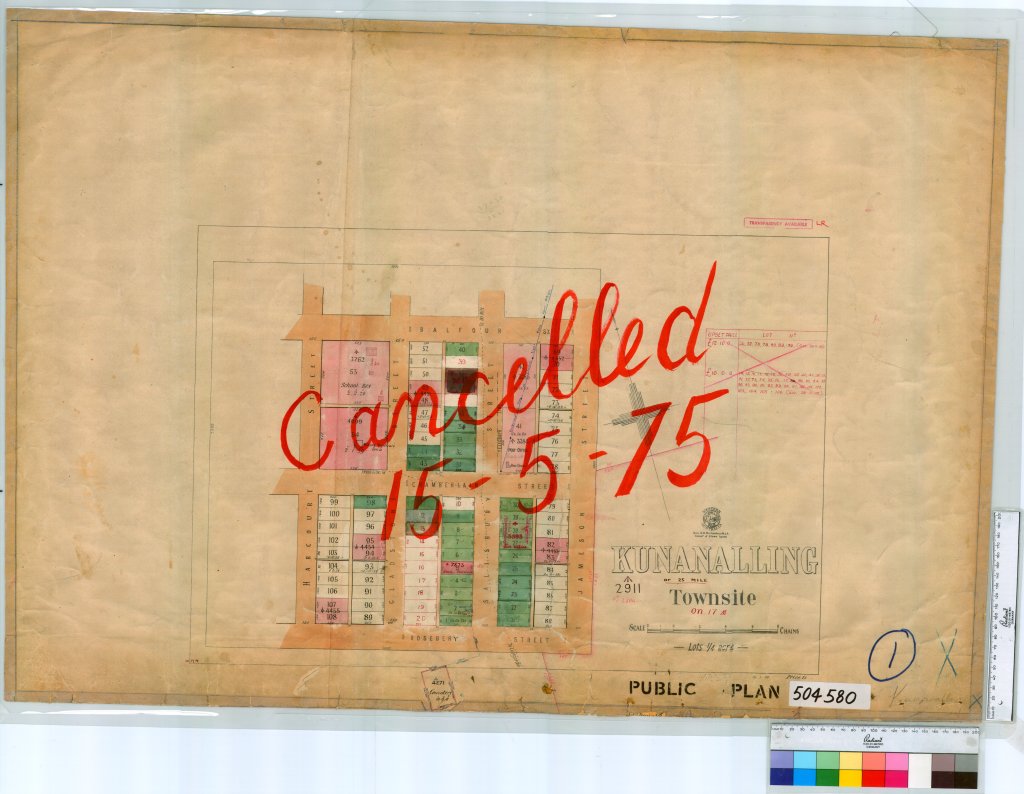
The town’s layout also reflected a certain political sentiment of the era. Its four main streets, Balfour, Chamberlain, Gladstone, and Salisbury, were all named after British Prime Ministers, suggesting a patriotic phase during the town’s formation.
Banks and Business
Kunanalling’s residents were often at odds with distant administrative authorities. A significant political and economic grievance in 1896 was the lack of a bank. Large mining companies paid their workers £4 per week each in cash, requiring the dangerous transport of huge sums of money along “bush tracks” prone to “sticking-up” by “land pirates.” The community felt that a bank or a Post Office Savings Bank would not only provide safety but also encourage thrift among the miners.28
The town was a staging post for Cobb & Co, who provided a daily horse-changing service for travellers on the route between Coolgardie and Menzies. A “convenient” Post and Telegraph Office was established, which served as the community’s primary link to the outside world, though the “remarkable nomenclature” and changing spellings caused ongoing confusion for the postal department.29 30
The Legacy of Kunanalling
The decline of Kunanalling was as swift as its rise. The closure of the Premier Mine in July 1903 dealt a “near-fatal blow” to the town’s economy. While some mining ventures continued and a brief resurgence occurred in the 1930s, even necessitating the reopening of the school in the Post Office building, the town could not sustain itself.31 32 33
By 1931, many government buildings had been dismantled and carted away. The onset of the Second World War saw the final exodus, with the last resident leaving in 1942. Kunanalling was officially abandoned, joining the ranks of the goldfields’ ghost towns.35 36
For those researching family ties to Kunanalling, the Kunanalling Cemetery remains a site of great importance. Though many graves are unmarked and the old fences have fallen into ruin, the cemetery serves as a silent ledger of the men, women, and children who once called the “Place of the Eagle Hawk” home.37 38Today, the site is a place of quiet reflection, marked only by the “crumbling walls” of the Premier Hotel and the vibrant wildflowers that bloom among the red dust each spring.
Timeline
- 1860s: Explorer Charles Hunt establishes a track from York to the goldfields, including water holes at rocks near the future site of Kunanalling.
- December 1892: Gold is discovered by James Speakman and his party; the site becomes known as the “25 Mile.”
- November 1893: John Dunne and a syndicate including John and Alexander Forrest acquire the “True Blue” lease (later Blue Bell).
- June 1893: The town is first gazetted (some sources cite later years for official gazettal).
- February 1894: A Receiving Office named “25 Mile” is established.
- 1895: A large Government water tank is constructed near granite rocks south of the town.
- November 1895: The “25 Mile” office is renamed “Coonalion” and upgraded to a Telegraph Office.
- 1896: The town is officially gazetted as “Kunanalling”; gold mining expands at the Premier Mine and Kintore cement leases.
- October 1896: Mining reporter Herbert Daly provides a detailed review of the Premier Mine and surrounding ventures.
- 1898: The town population reaches its peak of approximately 800 residents.
- April 1901: The Premier Hotel officially opens, featuring ten bedrooms and electricity.
- July 1903: The Premier Gold Mine is shut down, leading to the town’s primary economic decline.
- 1922–1926: “Gran” Kelly manages the Premier Hotel, introducing counter meals and Sunday ice cream.
- 1927: The Kunanalling school is closed and the building is later moved to Tammin.
- 1930s: A brief resurgence in mining activity leads to the reopening of the school in the Post Office building.
- 1942: The last resident departs, and the townsite is officially abandoned.
Map
Sources
- Western Australia Now and Then (2025). Kunanalling. Retrieved 25 Mar 2026 from https://www.wanowandthen.com/kunanalling.html ↩︎
- Sharp, Moya (2014). Kunanalling – Ghost Town. Retrieved 25 Mar 2026 from https://www.outbackfamilyhistoryblog.com/kunanalling-ghost-town/ ↩︎
- The Goldfields of W.A. (1896, October 12). The Kalgoorlie Miner (WA : 1895 – 1954), p. 2. Retrieved March 25, 2026, from http://nla.gov.au/nla.news-article87843002 ↩︎
- Hudson Institute of Mineralogy (2025). Mindat: Kintore-Kunanalling Goldfield, Coolgardie Shire, Western Australia, Australia. Retrieved 25 Mar 2026 from https://www.mindat.org/loc-266375.html ↩︎
- Johnstone, James (n.d.) Western Australia – 1869-1900: The 25 mile mines. Retrieved 25 Mar 2026 from https://telegramsaustralia.com/Forms/Telegraph%20Offices/Western%20Australia/25%20mile%20mines.html ↩︎
- State Library of Western Australia (n.d.) Views of the Eastern Goldfields; 72B/175. Published in the Western Australian Goldfields Courier 11 July 1896, p.18 with caption: Kunanalling township (25 Mile). Retrieved 26 Mar 2026 from https://encore.slwa.wa.gov.au/iii/encore/record/C__Rb5878855 ↩︎
- ibid ↩︎
- wikimapia (2016). Kunanalling. Retrieved 25 Mar 2026 from https://wikimapia.org/34418786/Kunanalling ↩︎
- Wikipedia (2013). Kunanalling, Western Australia. Retrieved 25 Mar 2026 from https://en.wikipedia.org/wiki/Kunanalling,_Western_Australia ↩︎
- Sharp, Moya (n.d.) Kunanalling – Western Australia (AKA the 25 Mile) GPS 30 41 05 S 121 04 0 E. Retrieved 26 Mar 2026 from https://www.outbackfamilyhistory.com.au/records/record.php?record_id=222 ↩︎
- Annear, Caitlin (2023) Explore Cornwall – The Cornish Abroad: The Ghost Town of Kunanalling. Retrieved 26 Mar 2026 from https://explorecornwall.org/the-ghost-town-of-kunanalling/ ↩︎
- KUNANALLING (1931, March 23). The Kalgoorlie Miner (WA : 1895 – 1954), p. 3. Retrieved March 26, 2026, from http://nla.gov.au/nla.news-article95214628 ↩︎
- WA Now and Then: refers to Speakman pegging the lease and the subsequent success of the Premier GM ↩︎
- Western Australia Now and Then (2024) Kunanalling Ghost Town – Western Australia. YouTube Video. Retrieved 26 Mar 2026 from https://youtu.be/6TahYouvUm4?si=xVdr5AmCMBbFftKa ↩︎
- The Goldfields of W.A. (1896, October 12). The Kalgoorlie Miner (WA : 1895 – 1954), p. 2. Retrieved March 26, 2026, from http://nla.gov.au/nla.news-article87843002 ↩︎
- Hudson Institute: refers to notable mines in the area ↩︎
- State Library of Western Australia (n.d.) Views of the Eastern Goldfields; 72B/37. Retrieved 26 Mar 2026 from https://encore.slwa.wa.gov.au/iii/encore/record/C__Rb5870033 ↩︎
- Kalgoorlie Miner (1896): refers to geology of the area ↩︎
- Hardman, Doug (2022) Ghost Towns – Kunanalling, Black Flag, Balgarri and Golden Valley. Retrieved 26 Mar 2026 from https://youtu.be/-DGKOR0jO_4?si=XYaEgb3Jk08l9vkF ↩︎
- Johnstone (n.d.): refers to the use of granite to catch rainwater ↩︎
- Kalgoorlie Miner (1896): refers to the water tank ↩︎
- Annear (2023): refers to water salinity ↩︎
- Wikipedia: refers population demographics ↩︎
- WA Now and Then (n.d.) refers to the hotels ↩︎
- Sharp (2014): refers to the various Kunanalling characters and characteristics ↩︎
- Annear (2023): refers to the stories of life in Kunanalling ↩︎
- State Records Office of WA (1975). Kunanalling Sheet 1 [Tally No. 504580]. Retrieved 26 Mar 2026 from https://archive.sro.wa.gov.au/index.php/kunanalling-sheet-1-tally-no-504580-0977 ↩︎
- Johnstone (n.d.): refers to banking facilities ↩︎
- WA Now and Then (n.d.): refers to coach service ↩︎
- Johnstone (n.d.): refers to telegraph office and the changing nomenclature ↩︎
- Sharp (2014): refers to the closure of the Premier Mine ↩︎
- Annear (2023): refers to the closure of the Premier Mine ↩︎
- Sharp (n.d.): refers to removal of buildings and the mining revival ↩︎
- State Library of Western Australia (n.d.) Stevenson, Kinder & Scott Corporate Photography ; BA1119/C4665-260,262-264. Retrieved 26 Mar 2026 from https://encore.slwa.wa.gov.au/iii/encore/record/C__Rb3041213 ↩︎
- KUNANALLING (1931, March 23). The Kalgoorlie Miner (WA : 1895 – 1954), p. 3. Retrieved March 26, 2026, from http://nla.gov.au/nla.news-article95214628 ↩︎
- Wikipedia: refers to the last residents ↩︎
- Sharp, Moya (n.d.) Kunanalling Cemetery. Retrieved 26 Mar 2026 from https://www.outbackfamilyhistory.com.au/records/record.php?record_id=762 ↩︎
- Hardman (2022): refers to the cemetery ↩︎
- What3Words.com (2026) Aerial Imagery. Retrieved 26 Mar 2026 from https://what3words.com/drops.tingly.overreact ↩︎
