Demographics
Region: Wheatbelt
LGA: Nungarin (Kwelkan), Trayning (Quelcan Well)
Industry: Agriculture
Other Names: Quelcan Well
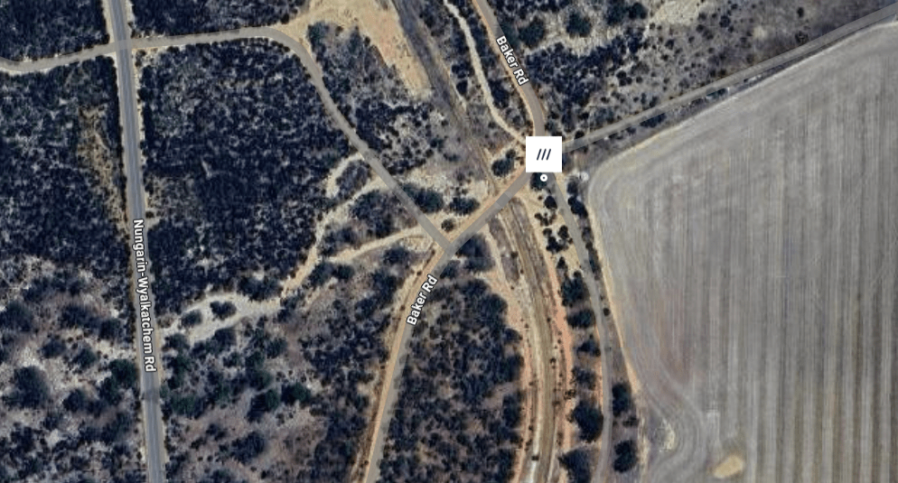
Open Street Map: -31.035489849759983, 118.00394723322371
What3Words: ///homeward.behold.regionals
Settled: 1910
Gazetted: 1912
Abandoned: 1975
Introduction
Kwelkan is a tiny, remote locality and former railway siding situated in the Wheatbelt region of Western Australia. Multiple sources confirm Kwelkan is administratively part of the Shire of Nungarin and derives its name from the Aboriginal term for a natural water source, the Quelcan Well. Census records from the Australian Bureau of Statistics indicate the area’s population is extremely low, listing as few as ten residents in the 2021 Census. Historically, the Kwelkan Townsite & Siding was essential to the district’s economy, serving as a significant grain shipment center until its bulk handling facilities were removed in the late 1970s. Contemporary travel information highlights the locality as an agricultural and historical destination, advising visitors that essential services and accommodation are typically found in nearby towns such as Nungarin and Merredin.
History
The history of Kwelkan, nestled in the heart of Western Australia’s Wheatbelt region, is a testament to the ambitious push of agriculture into the dry interior, and the subsequent reshaping of rural life by modern logistics. Its foundation was literally built upon the necessity of water and rail, and its eventual decline was marked by the systematic removal of the very infrastructure that had once cemented its economic importance.1
The Foundation of Water and Rail
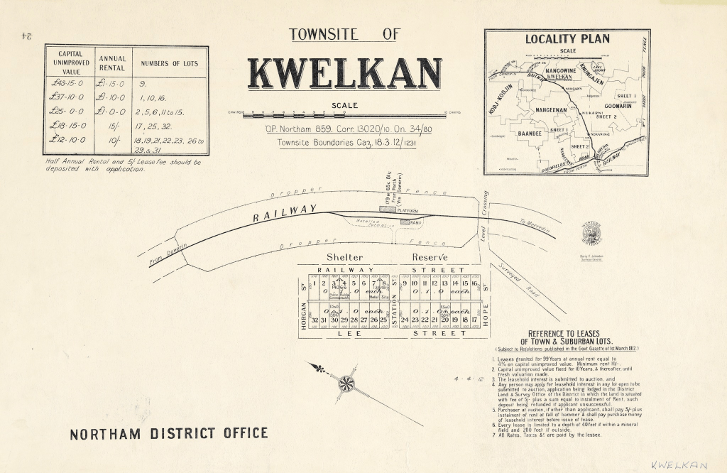
The story of Kwelkan begins with the natural environment and the age-old quest for water in a climate unforgiving of carelessness. The name itself is not merely an arbitrary designation, but a phonetic form of the Aboriginal name for a nearby water source: Quelcan Well. This well, located in the Shire of Trayning, approximately five to six kilometres north of the later railway station, provided the crucial resource necessary for exploration and early pastoral endeavor. The need to secure these water supplies drove the earliest bureaucratic actions concerning the site, with the townsite reserve (Reserve 13098) being officially set aside on November 11, 1910.2 3 4
The locality was positioned within a traditional Nyungar transitional area, where early European explorers, such as Surveyor General Captain John Septimus Roe in 1836, had observed the ingenuity of Indigenous water management, noting wells and gnamma holes covered to prevent contamination and evaporation.5 6 For the pioneers who followed, the availability of water, however precarious, dictated survival. Kwelkan was officially declared a townsite on March 18, 1912, aligning with the expansion of the Wheatbelt’s vital transportation links. Kwelkan was designated as a railway station or siding location, appearing on the Dowerin-Merredin Railway progress plans between 1912 and 1913. This economic link, facilitating the movement of goods and agricultural production, was indispensable.7
Yet, the dependency on water remained acute long after the official declaration. Historical records indicate persistent administrative attention to securing sufficient supply, detailing requests for a “Dam site Kwelkan” and a proposed tank in 1921. The records confirm that between 1914 and 1930, the locality relied upon “Trucked Water”, a telling detail illustrating the severe environmental challenge faced by settlers who sought to establish homes in this dry landscape.8
Agricultural Development
Once the essential infrastructure of water and rail was tenuously established, the surrounding region quickly developed into a significant agricultural district. Kwelkan’s destiny was irrevocably tied to the shipment of grain, demonstrating the district’s economic importance.9
The community reached its zenith with the modernization of grain handling. In 1938, Bulk Handling facilities were installed at Kwelkan Siding. This substantial investment, featuring a 1936-type bin capable of holding 1000 tonnes, confirmed Kwelkan as a critical service hub for Wheatbelt farmers.10
Contemporary records reveal glimpses of the farming life that supported Kwelkan. Though accommodation in the townsite may have been sparse, the locality fostered a sense of tight-knit community among seasoned locals who valued the serenity of the countryside. For gatherings and essential amenities, residents relied on adjacent towns, utilizing the markets and communal events in Nungarin and Merredin.11
Ecomonic Evolution Leads to Decline
Kwelkan’s eventual decline was not the result of natural disaster, but of economic evolution. As agricultural practices centralized, the smaller, decentralized sidings that once anchored communities like Kwelkan became obsolete.
The end of Kwelkan’s industrial purpose is precisely dated by the cessation of its primary function. The last recorded delivery of wheat to the Kwelkan bulk bin occurred in 1975. The physical markers of the town’s peak years were subsequently erased when the large grain bin was demolished and removed in 1978. The loss of this 1000-tonne facility effectively ended Kwelkan’s role as a commercial hub.12
Today, Kwelkan stands as a Historic Site, formally recognized as a Category 5 site—a designation for a historic place without built features. The population reflects this quiet status; recent Census data could not provide detailed community information due to the area having “no people or a very low population”. Current estimates place the population between 10 and 17 residents.13 14
Kwelkan offers a quiet escape, a serene, off-the-beaten-path locality, yet it serves as a powerful historical marker for the cycles of prosperity and decline witnessed across the Wheatbelt. It remains a testament to the determination of pioneers who built a town around the promise of water and the necessity of rail, only to see that promise fade when the economic landscape demanded centralization.
Timeline
- Pre-1910: The name Kwelkan originated from the Aboriginal term for a nearby water source, Quelcan Well.
- November 11, 1910: Reserve number 13098 was set aside for the townsite of Kwelkan.
- 1912: Kwelkan appeared on Progress Plans for Civil Engineering infrastructure.
- March 18, 1912: The townsite was officially declared under the Land Act.
- 1912: Kwelkan was known by the name Quelcan on railway timetables.
- 1912–1913: Kwelkan was included in the Progress Plans for the Dowerin/Merredin Block Plans.
- 1914–1930: Records show the provision of “Trucked Water” to Quelcan/Kwelkan.
- January 1, 1915: Kwelkan Cemetery Reserve 15859 was created.
- August 1921: Planning was recorded for the Kwelkan Water Supply Proposed Tank.
- 1937: Planning occurred for the G.W.S. Agricultural extension to Kwelkan.
- 1938: Construction of the Kwelkan Townsite & Siding began.
- 1938: Bulk Handling facilities (a 1000-tonne capacity bin) were installed at Kwelkan Siding.
- 1960–1961: Reticulation Investigation and Design was carried out for the water supply in Kwelkan.
- 1975: The last recorded delivery of wheat to the Kwelkan bin occurred.
- 1978: The agricultural grain bin was demolished and removed.
- September 9, 1988: Kwelkan Cemetery Reserve 15859 was cancelled.
- November 17, 1999: Kwelkan Townsite & Siding was adopted into the Municipal Inventory as a Historic Site.
- 2021: The locality recorded no people or a very low population in the Census.
Map
Sources
- Wiki Australia, n.d. Guide to Kwelkan. Retrieved 1 Dec 2025 from https://wikiaustralia.com/destination/kwelkan/ ↩︎
- Heritage Council of WA, 2017. Kwelkan Townsite and Siding. Retrieved 1 Dec 2025 from https://inherit.dplh.wa.gov.au/Public/Inventory/Details/e8d40e7b-a69e-4226-8db4-b249dfc364d4 ↩︎
- Mapcarta, n.d. Quelcan Well. Retrieved 1 Dec 2025 from https://mapcarta.com/30029028 ↩︎
- Mapcarta, n.d. Kwelkan. Retrieved 1 Dec 2025 from https://mapcarta.com/16481840 ↩︎
- Cornish, Maxine, 2010. A Piece of String: Stories of the Nungarin District. p.5-6. Retrieved 1 Dec 2025 from https://www.nungarin.com.au/uploads/5/6/1/5/56151793/a_piece_of_string_©_maxine_cornish_2010_.pdf ↩︎
- Heritage Council of WA, 2017. Talgomine Rock. Retrieved 1 Dec 2025 from https://inherit.dplh.wa.gov.au/Public/Inventory/Details/f723d2d5-c3ec-4479-87fa-133168c38f46 ↩︎
- State Records Office of WA, n.d. Search results providing insight into the development of Kwelcan including townsite, dam, cemetery, rail siding and other infrastructure projects. Retrieved 1 Dec 2025 from https://archive.sro.wa.gov.au/index.php/informationobject/browse?topLod=0&query=Kwelkan ↩︎
- ibid. ↩︎
- Heritage Council, Kwelkan: Refers to Kwelkan’s significance to grain shipment ↩︎
- ibid. ↩︎
- Wiki Australia, Kwelkan: Refers to community life in Kwelkan and the surrounding district ↩︎
- Heritage Council, Kwelkan: Refers to the last delivery of wheat and the demolition of the last grain bin ↩︎
- ibid : Refers to Kwelkan’s Category 5 heritage listing ↩︎
- Australian Bureau of Statistics, 2021. 2021 Census All Persons QuickStats: Kwelkan. Retrieved 1 Dec 2025 from https://www.abs.gov.au/census/find-census-data/quickstats/2021/SAL50804 ↩︎
