Demographics
Region: Wheatbelt
LGA: Dumbleyung
Industry: Agriculture
Other Names: Merilup Brook, Merilup Creek
Open Street Map:
What3Words: ///redeye.hurdler.yields
Settled: 1907
Gazetted: 1912
Schools Close: 1950
Abstract
The history of Merilup is fundamentally defined by a significant geographic nomenclature shift, wherein the original name for a burgeoning settlement was relocated and repurposed. Established formally in 1907, Merilup initially designated the primary townsite area that was subsequently gazetted as Kukerin in 1912 upon the arrival of the railway terminus. The name Merilup itself, derived from the Aboriginal dialect, refers to the location where native inhabitants procured Wonnera wood for manufacturing spear-throwing sticks. Today, Merilup exists as a quiet rural locality, situated south of Kukerin, within the Shire of Dumbleyung, maintaining a sparse population that continues the agricultural legacy of broadacre crops and livestock farming. The community’s trajectory illustrates the typical pattern of establishment, infrastructure development (including three scattered schools), and eventual consolidation into a larger regional hub.
History
The Enduring Place of the Wonuera Wood
Merilup, situated in the Wheatbelt region of Western Australia, possesses a history intertwined with both ancient Aboriginal tradition and the rugged determination of early European pioneers. Long before it became a pastoral or agricultural outpost, the name Merilup held deep indigenous meaning. According to “King George” of the local aboriginal community, Merilup describes the place where the native inhabitants traditionally obtained the Wonnera wood, which was essential for crafting sticks used to propel their spears. This connection to the land and its resources pre-dates European settlement, grounding the place in a heritage of sustenance and utility.1 2
The geographical area now known as Merilup is a locality covering approximately 221.1 square kilometres. It lies southeast of Perth, situated between Dumbleyung and Lake Grace, located within the jurisdiction of the Shire of Dumbleyung.3
Sandalwood, Pastoralism, and Early Infrastructure
The genesis of modern settlement in the wider Merilup area is traced back to the burgeoning economic activities of the late 19th and early 20th centuries. The official establishment of the locality dates back to 1907.4
Economic Factors: Sandalwood and Sheep
The economic foundation of the area was laid by early pastoral activity. John Holland, a significant figure in the region’s history, took up a substantial pastoral lease of 9,000 acres (36 km²) in the 1870s. He established a sandalwood depot, and the cutters who worked for this industry were instrumental in opening up the surrounding land for subsequent use. The presence of these early enterprises signifies the initial economic viability of the region, driven by accessible timber resources and extensive land suitable for grazing.5
The Rabbit -Proof Fence
In 1904, a major piece of infrastructure reflecting broader colonial priorities passed nearby: the Rabbit-Proof Fence was constructed adjacent to the future townsite. While serving an agricultural protection purpose, its construction further marked the land and created routes and access points for incoming settlers.6
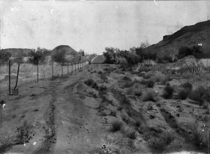
SLWA7
Pioneers began taking up agricultural land in the district, laying the groundwork for the modern Wheatbelt economy. One notable figure, McMahon, who would later be an early identity in Lake Grace and responsible for excavating the second dam at White Dam in 1912, first took up land at Merilup before settling in Lake Grace in 1908. Documentation from the State Records Office also confirms early farming activity, listing a “Merilup farm, Dumbleyung” associated with G. H. Lawrance in both 1912 and 1924. Official planning documents related to the establishment of Merilup (listed historically as East Wagin) date back to 1910, with cancelled public plans referencing Merilup Locations commencing as early as 1911 and 1912.8 9 10
The Great Confusion: Merilup Creek to Kukerin
Perhaps the most challenging aspect of Merilup’s history for the general reader is the fundamental shift in its name and location. Initially, the settlement area that was slated to become the townsite was known as Merilup. This area was situated near natural water sources, including Merilup Creek and Spring, which were historically documented on cancelled public plans. 11
The critical change occurred in 1912 when the area that had been known as Merilup became the officially gazetted townsite of Kukerin. This shift coincided with the establishment of the terminus for the extension of the Wagin to Dumbleyung railway line. Due to this infrastructure development and gazettal, the name Merilup was subsequently relocated, coming to refer to the agricultural area or locality situated immediately to the south of Kukerin. This naming convention has persisted; Kukerin developed into the main service town for the area, while Merilup remains a designated locality within the Shire of Dumbleyung. Further historical files illustrate the confusion or proximity, such as records concerning the establishment of a school at Merilup South (Kukerin) in 1929.12
Social Development and Decline
Following the establishment of Kukerin as the service centre, the Merilup locality continued its existence as a widespread rural community. The growth phase of Merilup, focused on agricultural settlement, necessitated the establishment of social infrastructure.13 Documentation indicates files regarding Merilup buildings in 1916 and 1923, and records of school attendance in 1922.14 As the population grew across the scattered farming districts, educational facilities were developed. The Merilup area witnessed the construction of three separate schools between 1922 and 1950. Records also show files related to the proposed removal of the Pingarning school for the erection of a Merilup School.15
However, the forces of consolidation eventually led to the decline of these localised social structures. In a major turning point marking the locality’s demographic retreat, the final school operating within the Merilup area closed in December 1950, with its resources and pupils consolidated into the larger Kukerin school.16
Water infrastructure was a critical necessity for the dispersed population and farming operations. Records from the 1920s show requests for water supply tanks, specifically for the North Merilup area, including one proposed at the junction of Merilup and Pingarup Roads. These records highlight the continuous efforts required to sustain rural life in this dry environment.17
Present day
The modern Merilup locality is ecologically and economically defined by its setting in the Wheatbelt region.
Merilup is characterised by a hot-summer mediterranean climate. The majority of the locality is classified as Regional Rural (93.48%), though a significant portion (4.79%) is designated as Environmental Conservation Reserve.18 19 Environmental surveys have been conducted on the area, including a 1:200,000 scale hydrogeological map of the Merilup Catchment, published in 1993, which provides details regarding the area’s water resources.20 Geologically, Merilup sits within the ancient crustal architecture of the Southern Cross Province and the Western Gneiss Terrane of the Yilgarn Craton [Author’s note: a Craton is an old and stable part of the earth’s crust]. The average rainfall in the nearby Kukerin area is modest, with a yearly average of 396.4 mm.21 22
Economic Sustenance
Merilup remains intrinsically an agricultural locality. Its residents derive their livelihood from farming, primarily managing livestock and producing a range of broadacre crops. This reliance on agriculture explains why 100% of those employed in the area reported travelling to work by car, reflecting the necessity of mobility across scattered farms.23
The modern locality of Merilup, sharing a postcode with Kukerin, is now economically and socially dependent on the nearby townsite for essential services, such as groceries and postage.24
The Demographic Retreat
The definitive decline of Merilup as a thriving, independent small community is vividly reflected in recent Australian census data, underscoring a trend common across remote agricultural localities.
In the 2016 Census, Merilup was home to 21 people residing in 14 private dwellings. The median age was 51 years. Demographically, the area was characterized by households primarily owned outright by couples without children.25
By the time of the 2021 Census, the population had experienced a marked decline, dropping to just 13 people. The median age rose slightly to 55 years. The number of private dwellings also sharply reduced to only five.26
This demographic retreat highlights the ongoing challenges faced by smaller, isolated agricultural communities that rely heavily on consolidation into larger regional centres like Kukerin. Merilup today stands as a testament to the pioneering spirit of the Wheatbelt, evolving from a traditional gathering place for Wonnera wood into a contemporary, sparsely populated rural locale defined by its productive landscape.
Timeline
- Ancient History: Merilup serves as the place where native inhabitants gathered Wonnera wood for making spear-throwing sticks.
- 1870s: John Holland takes up a 9,000-acre pastoral lease in the area then known as Merilup and establishes a sandalwood depot.
- 1904: The Rabbit-Proof Fence is constructed near the area.
- 1907: Merilup locality is established.
- 1908: Pioneer McMahon first takes up land at Merilup.
- 1912: The settlement area previously known as Merilup is officially gazetted as the townsite of Kukerin, coinciding with the arrival of the railway terminus. The name Merilup subsequently refers to the region south of Kukerin.
- 1921: Files related to North Merilup water supply and tank requests are created.
- 1922: Departmental files reference school attendance at Merilup; the first of three schools is built in the area (between 1922 and 1950).
- 1929: Establishment of the Merilup South (Kukerin) school is documented.
- December 1950: The final school in the Merilup area is closed and consolidated into Kukerin’s school, marking a significant step in the social decline of the independent locality.
- 1993 (April 1): Hydrogeological map of the Merilup Catchment is published, detailing water resources in the area.
- 2016: Census records Merilup population at 21 people.
- 2021: Census records Merilup population dropping to 13 people, highlighting ongoing demographic retreat
Map
Sources
- Wikipedia, 2025. Merilup, Western Australia. Retrieved 3 Dec 2025 from https://en.wikipedia.org/wiki/Merilup,_Western_Australia ↩︎
- THE MEANING OF NATIVE NAMES. (1925, September 18). The Wagin Argus and Arthur, Dumbleyung, Lake Grace Express (WA : 1924 – 1954), p. 3. Retrieved December 3, 2025, from http://nla.gov.au/nla.news-article257758335 ↩︎
- Mapcarta, n.d. Merilup. Retrieved 3 Dec 2025 from https://mapcarta.com/16478666 ↩︎
- Wikipedia, Merilup: refers to establishment of Merilup ↩︎
- Wikipedia, 2025. Kukerin, Western Australia. Retrieved 3 Dec 2025 from https://en.wikipedia.org/wiki/Kukerin,_Western_Australia ↩︎
- ibid. ↩︎
- State Library of Western Australia, n.d. The Rabbit Proof Fence. Retrieved 3 Dec 2025 from https://slwa.wa.gov.au/stories/wa-history/rabbit-proof-fence ↩︎
- Heritage Council of WA, 2021. McMahon‘s Buildings. Retrieved 3 Dec 2025 from https://inherit.dplh.wa.gov.au/public/inventory/printsinglerecord/beed1bcb-f416-43e3-9450-ffcc41d352f5 ↩︎
- Carnamah Historical Society & Museum, n.d. WA Livestock Brands 1912-1962: Merilup. Retrieved 3 Dec 2025 from https://www.carnamah.com.au/livestock-brands?keyword=Merilup ↩︎
- State Records Office of WA, 2025. Search results for Merilup. Retrieved 3 Dec 2025 from https://archive.sro.wa.gov.au/index.php/informationobject/browse?topLod=0&query=merilup ↩︎
- ibid. ↩︎
- Wikipedia, Kukerin: refers to naming of Kukerin and redefining the name of Merilup ↩︎
- Wikipedia, Merilup: refers to the development as Merilup as a locality ↩︎
- State Records Office of WA, Merilup: refers to school attendance and building permits ↩︎
- Wikipedia, Merilup: refers to provision of schools ↩︎
- ibid: refers to closure of Merilup area schools ↩︎
- State Records Office of WA, Merilup: refers to supply of water tanks ↩︎
- mindat, n.d. Merilup, Dumbleyung Shire, State of Western Australia, Australia. Retrieved 3 Dec 2025 from https://www.mindat.org/feature-2066494.html ↩︎
- Landchecker, n.d. Merilup WA 6352. Retrieved 3 Dec 2025 from https://landchecker.com.au/suburb/merilup-wa-6352/ ↩︎
- Dept of Mines, Petroleum and Exploration, 1993. Merilup Catchment. Map retrieved 3 Dec 2025 from https://dmpbookshop.eruditetechnologies.com.au/product/merilup-catchment.do ↩︎
- mindat, Merilup: Refers to Merilup geology ↩︎
- Wikipedia, Kukerin: refers to climate data for Kukerin/Merilup area ↩︎
- Landchecker, Merilup: refers to demographic data ↩︎
- Wikipedia, Merilup: refers to dependency on Kukerin for services ↩︎
- Australian Bureau of Statistics, 2016. 2016 Census All Persons QuickStats: Merilup. Retrieved 3 Dec 2025 https://abs.gov.au/census/find-census-data/quickstats/2016/SSC50925 ↩︎
- Australian Bureau of Statistics, 2021. 2021 Census All Persons QuickStats: Merilup. Retrieved 3 Dec 2025 https://abs.gov.au/census/find-census-data/quickstats/2021/SAL50935 ↩︎
Further reading
- Across the Lake: A History of Lake Grace 1911-1992 by J. Bird
- Beyond the Fence by Joan Timperley
- Sandalwood
