Christine Harris 2026
Demographics
Region: Wheatbelt
LGA: Beverley
Industry:Railway and agriculture
Other Names: Rokeby
Open Street Map: -32.15934598269284, 116.97419218307891
What3Words: ///transistor.sludgy.breezed
Settled: 1899
Gazetted: 1902
Abandoned: About 1955
Abstract
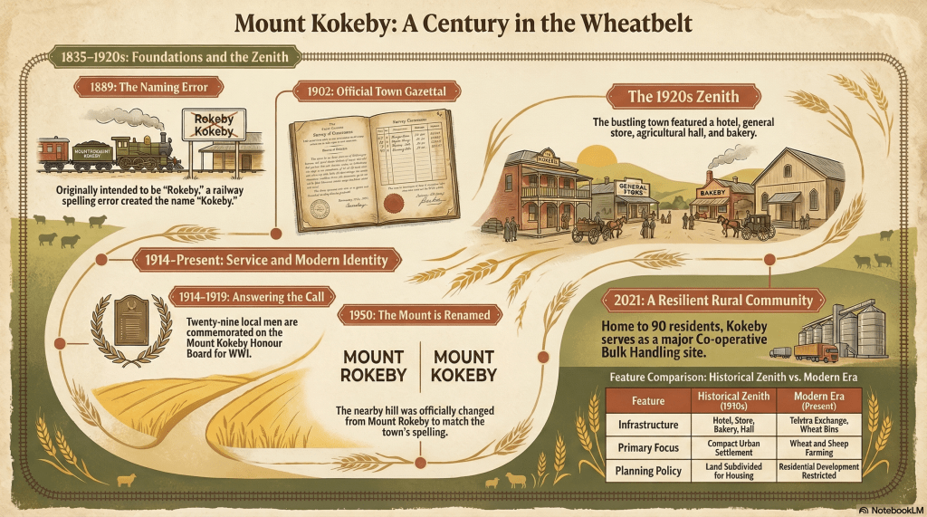
Mount Kokeby, situated in the Wheatbelt region of Western Australia, represents a poignant example of the “rise and fall” narrative common to many early 20th-century Australian rural settlements. Originally intended as a bustling railway hub, the town’s origins were marked by a clerical error—a misspelling of “Rokeby” that became permanent. Following its official gazettal in 1902, the town experienced significant growth, fuelled by the expansion of the Great Southern Railway and the prosperity of wheat and sheep farming. By the 1920s, Mount Kokeby boasted a hotel, a school, and various commercial enterprises. However, the advent of the motor vehicle and improved road networks eventually rendered small railway sidings obsolete, leading to a steady decline in population and services. Today, the community consists of approximately 90 residents and serves primarily as a grain receival point. Recent history has been dominated by planning challenges regarding the “Anglo Estate,” where historical subdivisions lack the necessary infrastructure for modern residential development. This abstract outlines a history shaped by economic ambition, wartime sacrifice, and the eventual consolidation of rural life into larger regional centres.
History
Mount Kokeby is a small locality situated in the Avon Arc of the Western Australian Wheatbelt, approximately 12 kilometres south of Beverley. While today it is a quiet agricultural area, its history is a complex tapestry of administrative errors, rapid economic expansion, and the inevitable social shifts brought about by technological progress.
Discovery and the “Kokeby” Error
The origins of the area’s name are found in the mid-19th century. In 1835, John Septimus Roe named a nearby landmark Mount Rokeby, in honour of Henry Montagu, the 6th Baron Rokeby of Armagh. The transition from “Rokeby” to “Kokeby” was not a deliberate choice but a clerical misspelling that occurred when a station on the Great Southern Railway was opened in 1889. Despite the error, the name persisted, and in 1950, the name of the nearby hill was officially changed to match the town’s misspelling.
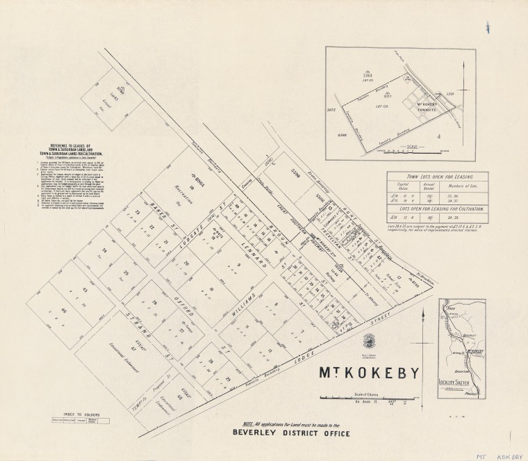
The formal establishment of the townsite followed the railway’s arrival. In 1899, a government land agent in Beverley noted the potential for development adjacent to the station. Consequently, after a survey of the land, the townsite of Mount Kokeby was officially gazetted on 20 June 1902.1 2
SLWA3
Growth and the Zenith of the 1920s
The early 1900s marked a period of great optimism for the community. The town was strategically placed to service the burgeoning wheat and sheep industries of the surrounding district. This economic foundation supported a rapid expansion of infrastructure. At its peak in the 1920s, the township featured a Victorian Regency-style hotel, a general store, a bakery, wheat sheds, and an agricultural hall. Essential services were provided by local tradesmen, including blacksmiths and wheelwrights.
Social life was anchored by the local school and the Agricultural Hall. Records indicate a steady stream of educators served the community, such as Head Teacher John C. Adlard and Sewing Mistress Alice Adlard, who were active in the years preceding World War I. Other notable teachers included Harry Crocos and Howard Beau-Leeney, the latter serving into the 1940s. The presence of these families and professionals highlights a settled, self-sufficient community with a clear vision for its future.4
The agricultural success of the region was further evidenced by the many livestock brands registered to local properties. Families such as the Blechyndens of “Manadale” and “Erindale,” the Butchers of “Mail Rock,” and the Bowrons of “Blaming Hill” were instrumental in establishing the area’s reputation for primary production.5
Fire
On the night of 20 February 1906, the newly gazetted township of Mount Kokeby suffered a devastating blow when its Grain Shed was destroyed by fire. The alarm was raised around 8:00 PM by Charlotte Gould, who spotted a flickering light through the shed’s fanlight.
Caretaker and local blacksmith Ernest Pentzin, a former member of the Perth Fire Brigade, rushed to the scene and found a stack of chaff already ablaze. Despite his firefighting experience, the lack of infrastructure, with only 50 gallons of water available, rendered his efforts futile. By the time Constable Henry Wood arrived from Beverley at 10:15 PM, the iron-walled structure was completely levelled.
The economic impact was severe for the agricultural community. While the building was insured for £400, much of the contents were not. McLean Bros lost 347 bags of wheat and eight tons of superphosphates. Pentzin personally lost £60, including his tools and business records. A coronial inquest later determined the shed was destroyed by fire, but the specific cause remained a mystery, leaving theories regarding camping swagmen or a stray match unproven.6
In a sad footnote to this story, Ernie Pentzin was killed in action in September 1916 at Hod Amara, Egypt.7
Wartime Sacrifice and Social Impact
Like many Australian country towns, the First World War had a profound and sobering impact on Mount Kokeby. The community “answered the call” with vigour, a fact immortalised on the Mount Kokeby Honour Board now held at the Beverley Town Hall. Twenty-nine veterans from the area are listed on the memorial.
The cost of the conflict was high. Among those who did not return were Company Sergeant Major George Samuel Feist, killed in action in France in 1916, and Private Malcolm Leslie Higgins, who died of wounds that same year. Other local men, such as Rupert Thomas Jose and Eric George Sutherland, also lost their lives in service. These losses significantly impacted the social fabric of the small settlement, removing a generation of young men who would have otherwise contributed to its post-war growth.8 9 10 11
Economic Shifts and the “Death Knell” of Decline
The decline of Mount Kokeby was not sudden but was driven by significant environmental and economic factors. The State Heritage Office notes that the “death knell” for such compact, self-sufficient communities was the rise of modern roads and the motor vehicle. As transportation became more efficient, residents found it easier to travel to larger centres like Beverley or Northam for services, reducing the need for local businesses like the bakery or general store.
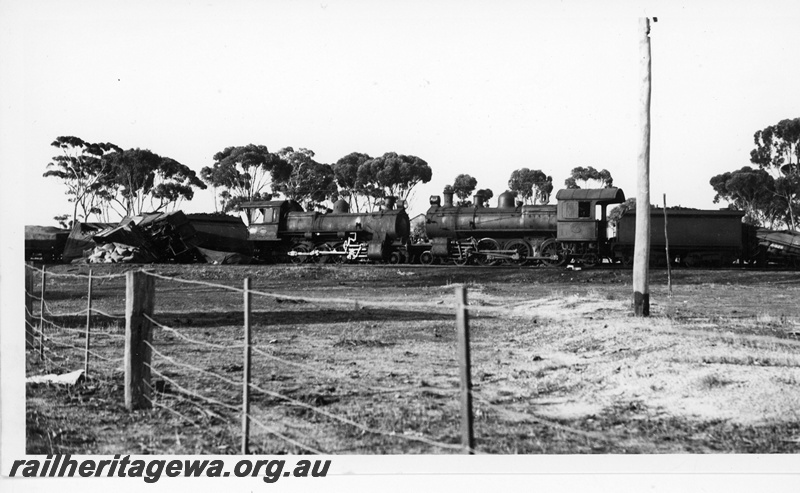
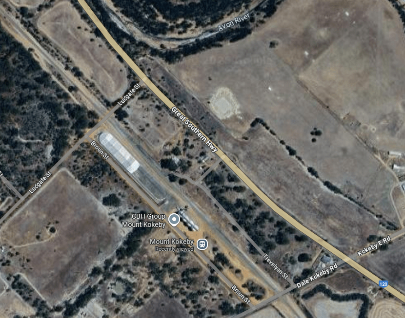
By the mid-20th century, the town had begun to shrink. The railway station, once the heart of the community, eventually closed and was removed. The Agricultural Hall was demolished, and the bustling streetscape of the 1920s faded. While the area remained a vital part of the Wheatbelt’s grain production—continuing to serve as a Cooperative Bulk Handling (CBH) receival site—its status as a residential and commercial hub effectively ended.12 13 14
Modern Kokeby and Planning Challenges
In the 21st century, Mount Kokeby is characterised by its small, stable population. The 2021 Census recorded 90 people living in the locality, with a median age of 57. The landscape is dominated by large-scale farming, a Telstra exchange, and the prominent CBH grain bins.16
A significant political and planning issue in recent decades has been the “Anglo Estate.” This area was subdivided into small residential lots in 1906, intended for the then-growing town. However, these lots remained largely undeveloped. In the 1990s, the Shire of Beverley began a consistent policy of refusing residential development on these lots. The reasons were primarily environmental and economic: the area lacks reticulated water, the soil is poorly suited for on-site effluent disposal, and many lots lack proper road access.
The Shire has maintained that supporting residential growth in this unserviced “Rural” zone would be “irresponsible,” preferring to protect the rural amenity and agricultural viability of the land. To resolve the issue, the Council has even offered financial incentives for landowners to surrender these potentially undevelopable lots.17
Conclusion
The history of Mount Kokeby serves as a reminder of the shifting nature of rural Australia. From its beginnings as a misspelled railway siding to its golden age as a thriving service town, and finally to its current role as a quiet agricultural precinct, the community has been shaped by the forces of global conflict, technological evolution, and environmental reality. While the physical town has largely vanished, the legacy of its pioneers and the sacrifice of its soldiers remain a vital part of the region’s heritage.
Timeline
- 1835: John Septimus Roe names Mount Rokeby.
- 1889: The Great Southern Railway opens a station; the name is misspelled as “Mount Kokeby”.
- 1899: Government land agent suggests land be made available for a townsite.
- 1902: Mount Kokeby townsite is officially gazetted on 20 June.
- 1904: Rosina J. Collard serves as the first recorded Head Teacher at the local school.
- 1906: The “Anglo Estate” area is subdivided for urban housing.
- 1913-1914: Early settlers like the Cranfield family arrive from England to establish farms.
- 1914-1918: Twenty-nine local men serve in World War I; several, including George Samuel Feist and Malcolm Leslie Higgins, are killed in action.
- 1920s: The township reaches its zenith with a hotel, store, bakery, and professional services.
- 1940s-1950s: The town begins a steady decline as motor vehicles change transport habits.
- 1950: The name of the nearby hill is officially changed from Mount Rokeby to Mount Kokeby to match the townsite.
- 1961: Former residents Edgar Prowse and Fred Collard are elected to Federal Parliament.
- 1996: A test case upholds the Shire’s refusal to allow residential dwellings on the Anglo Estate lots.
- 2021: Census records a population of 90 for the Kokeby locality.
- 2025: A significant bushfire incident is recorded in the area in December.
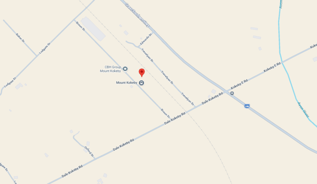
Map
Sources
- Wikipedia (2022). Mount Kokeby , Western Australia. Retrieved 23 Feb 2026 from https://en.wikipedia.org/wiki/Mount_Kokeby,_Western_Australia ↩︎
- Heritage Council of Western Australia (2017). Mount Kokeby Townsite. Retrieved 23 Feb 2026 from https://inherit.dplh.wa.gov.au/public/inventory/details/38d7982d-0dbd-47cc-ad87-31c1e2400be1 ↩︎
- State Library of Western Australia (n.d.) Cadastral Map – Mt Kokeby. retrieved 23 Feb 2026 from https://encore.slwa.wa.gov.au/iii/encore/record/C__Rb1945128 ↩︎
- Carnamah Historical Society & Museum (n.d.) WA State School Teachers 1900-1980. Retrieved 23 Feb 2026 from https://www.carnamah.com.au/teachers?keyword=kokeby ↩︎
- Carnamah Historical Society & Museum (n.d.) Livestock Brands of Western Australia. Retrieved 23 Feb 2026 from https://notebooklm.google.com/notebook/6c3cb6c1-be6e-493d-bf42-076536db7f46?authuser=2 ↩︎
- THE FIRE AT MT. KOKEBY. (1906, March 24). Eastern Districts Chronicle (York, WA : 1877 – 1927), p. 2. Retrieved February 23, 2026, from http://nla.gov.au/nla.news-article148610608 ↩︎
- Fremantle History Centre (n.d.) No.459 Corporal Ernest Pentzin – 10th Light Horse Regiment. Retrieved 23 Feb 2026 from https://history.fremantle.wa.gov.au/nodes/view/46844 ↩︎
- Dept of Premier & Cabinet (2004). Mount Kokeby Honour Board. Retrieved 23 Feb 2026 from https://webarchive.nla.gov.au/awa/20040915164510/http://pandora.nla.gov.au/pan/42657/20040615-0000/www.anzac.dpc.wa.gov.au/index7c1b.html ↩︎
- Highgate RSL (n.d.) WA War Memorials and Honour Boards. Retrieved 23 Feb 2026 from https://highgate-rsl.org.au/wp-content/uploads/2019/05/Mount_Kokeby_RoH.pdf ↩︎
- Australian War Memorial (n.d.) Roll of Honour: George Samuel Feist. Retrieved 23 Feb 2026 from https://www.awm.gov.au/collection/R1733150 ↩︎
- ibid: Malcolm Leslie Higgins. Retrieved 23 Feb 2026 from https://www.awm.gov.au/collection/R1634531 ↩︎
- Heritage Council of WA: refers to the rise and fall of Mount Kokeby ↩︎
- Shire of Beverley (2019). Local Planning Policy: Anglo Estate (Mount Kokeby). Retrieved 23 Feb 2026 from https://www.beverley.wa.gov.au/Profiles/beverley/Assets/ClientData/Documents/Town_Planning/20191001AngloEstate.pdf ↩︎
- Wikipedia, 2022: refers to the CBH ↩︎
- Rail Heritage WA (n.d.) WAGR D.A. Finlayson Collection: P20075. Retrieved 23 Feb 2026 from http://railheritagewa.org.au/archive_scans/displayimage.php?pid=25684 ↩︎
- Australian Bureau of Statistics (2021). Census All persons QuickStats: Kokeby. Retrieved 23 Feb 2026 from https://abs.gov.au/census/find-census-data/quickstats/2021/SAL50772 ↩︎
- Shire of Beverley, 2019: refers to Shire Police on residential development ↩︎
- Google Maps (2026). Mount Kokeby. Retrieved 23 Feb 2026 from https://www.google.com/maps/place/32%C2%B012’38.5%22S+116%C2%B058’21.2%22E ↩︎
