Demographics
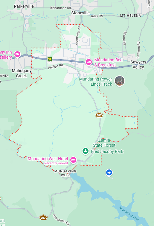
Region: Perth
LGA: Mundaring
Industry: Water Infrastructure
Other Names: Gugeri, Gugeri’s Siding, Sexton’s Siding, Holmes & Blaine’s Siding, Mundaring Weir, No.1 Pumping Station, Goldfields Weir Hotel
Open Street Map: -31.95, 116.16667
What3Words: ///collarbone.instructs.rhythm
Settled: 1870
Gazetted: 1898 Abandoned: ~1903
Abstract
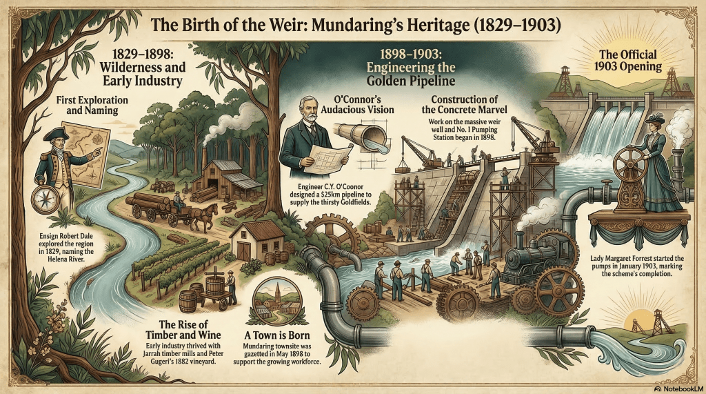
The history of Mundaring Weir and its surrounding locality is a narrative of engineering ambition, environmental transformation, and social evolution. Originally known to the Whadjuk Noongar people as a “high place on a high place,” the area’s European history began with exploration in 1829, followed by the development of the York Road and a burgeoning timber industry. The late 19th century saw the arrival of viticulture, with Peter Gugeri and later the Jacoby family establishing the vineyards that would eventually give the town its name.
The defining moment for the region was the construction of the Goldfields Water Supply Scheme between 1898 and 1903. Championed by Sir John Forrest and designed by C.Y. O’Connor, the Mundaring Weir was built to solve the desperate water famine in the Eastern Goldfields. This project brought rapid settlement, industrial spur lines, and the establishment of vibrant social hubs like the Mundaring and Mundaring Weir Hotels. Throughout the 20th century, the locality navigated economic shifts from primary production to tourism, eventually becoming a “dormitory” suburb of Perth. Today, the Weir remains a critical infrastructure site, adapted for climate change while serving as a cultural touchstone for Western Australian heritage.
Christine Harris (2026)
History
The locality of Mundaring, nestled within the Darling Range approximately 39 kilometres east of Perth, possesses a history as layered as the granite scarp upon which it sits. Its name, derived from the Whadjuk Noongar language, is widely believed to mean “a high place on a high place”. Alternatively, some linguistic interpretations suggest the word “mundak” refers to the “bush” or “wild country”. For millennia, the Noongar people moved between the coastal plains and these forested hills, utilizing tracks across the escarpment and using the forest below the modern weir site as a camping ground. Indigenous legend identifies Mundaring as an important meeting place, though the arrival of European explorers in the early 19th century would initiate a radical transformation of the landscape.2 3 4
Exploration and the Era of the York Road (1829–1880)
The first European recorded to have ascended the Darling Escarpment was Ensign Robert Dale, who explored the region in October 1829 and named the Helena River after his sister. While Dale discovered the fertile Avon Valley beyond the hills, the Mundaring area initially served primarily as a transit point. By the 1840s, a route to York was surveyed, and the locality became a vital stop for travellers.5 6 7
Political and economic support for infrastructure led to the construction of roadside inns, most notably the Travellers’ Inn (also known as Horton’s Half-Way House), built around 1855 near Manaring Lake. These inns provided essential respite for mail carriers and settlers, reflecting the social fabric of a colonial frontier. During the 1870s, convict road parties were stationed in the area to maintain the York Road. A local legend from this era tells of a warder’s handbell, used to regulate convict life, which disappeared under suspicious circumstances in 1871 and remains a lost piece of the district’s history.8 9
Timber, Wine, and Early Industry (1880–1897)
The economic potential of the Darling Range’s hardwood forests, specifically Jarrah and Wandoo, was realized by the late 19th century. A lucrative timber export trade was established, with sleeper cutters and sawpit operators felling massive trees to support the expansion of the British Empire’s railways and harbours. In 1883, a timber concession was granted to Smith and Company, and by 1889, a sawmill was established, leading to the creation of a railway stopping place known as Gugeri’s Siding.10 11 12
Parallel to the timber industry, viticulture became a cornerstone of Mundaring’s early economy. In 1882, Peter Gugeri, a wine merchant with experience in Italy, established the “St Bernards” vineyard. Despite early success, exceptional frosts and an economic crash in the 1890s forced Gugeri to sell his property in 1893 to the Jacoby family. The Jacobys renamed the business the Mundaring Vineyard Company, adopting the local Aboriginal name. Mathieson Jacoby, the farm manager and a future Member of Parliament, became a prominent figure in the community, even after losing an eye in a blasting accident on the farm in 1897. Under his guidance, the area expanded into successful fruit orcharding, particularly apple exports, which Jacoby championed to offset competition from Federation.13 14
The Goldfields Water Pipeline (1898–1903)
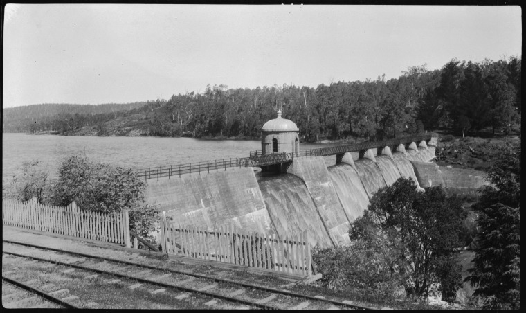
The most significant political driver for the locality’s growth was the Goldfields Water Supply Scheme. Following the discovery of gold at Kalgoorlie in 1893, the Eastern Goldfields suffered from severe water shortages and typhoid outbreaks. Premier Sir John Forrest proposed an ambitious plan to dam the Helena River and pipe water 525 kilometres inland. The project was designed by the colony’s Chief Engineer, Charles Yelverton (C.Y.) O’Connor.15 16 17
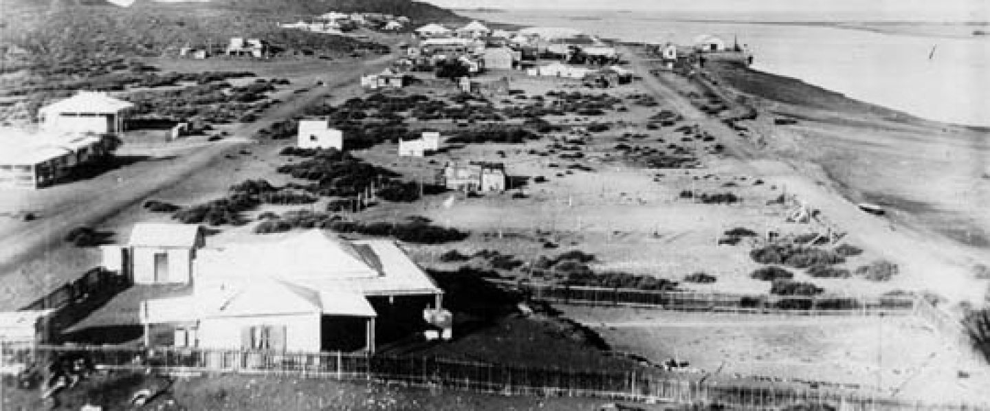
The site for the Mundaring Weir was chosen in a steep rocky gully on the Helena River, and construction began in April 1898. This industrial undertaking necessitated the building of a spur railway line from the Mundaring township to the weir site to transport men and materials. The influx of workers seeking employment on the scheme prompted the government to formally gazette the Mundaring townsite on 20 May 1898.18 19 20 21 22 23
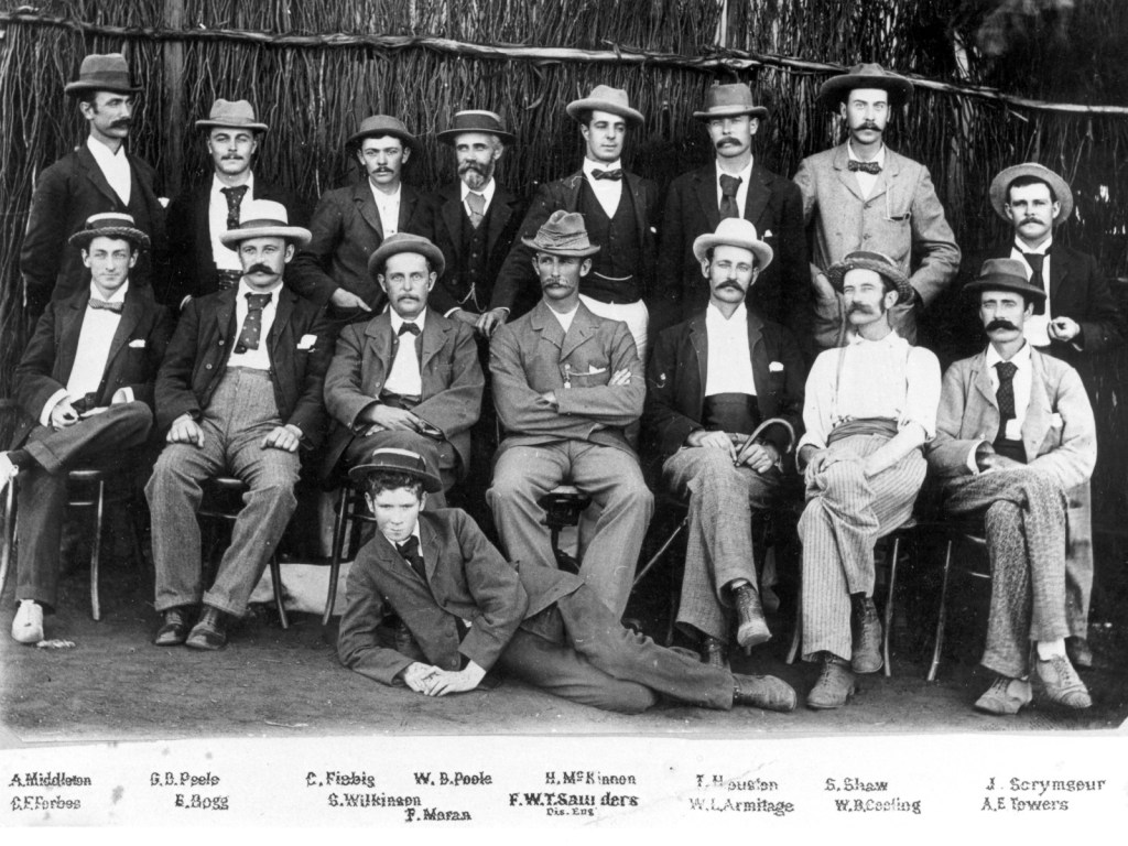
The project was mired in political controversy and vitriolic press attacks against O’Connor’s integrity and the feasibility of the scheme. Tragically, under immense personal and professional pressure, O’Connor committed suicide in March 1902, just months before the project’s completion. Despite this, the weir was completed in 1903, and water reached Kalgoorlie in January of that year, heralded as a technological marvel. The No. 1 Pumping Station at the base of the weir wall became the heart of this “Golden Pipeline”.25 26 27
A Fashionable Retreat (1900–1940s)
Following the Weir’s completion, Mundaring transformed into a premier tourist destination. The project caught the public imagination, and the area was promoted as a “healthy retreat” from the dust of Perth and the Goldfields. The Mundaring Hotel, established in 1899 by John Frank and Harold Hummerston, became the social centre of the district, hosting everything from masonic lodge meetings to wine-growing contests.28
Nearer the reservoir, the Jacoby brothers built the Goldfields Reservoir Hotel (later the Mundaring Weir Hotel) in 1898 to house visitors and workers. The hotel was later expanded into a grand two-storey structure in 1906, featuring construction materials shipped from England. The “invigorating” air of the hills even led Fred Jacoby to promote the hotel as “Westralia’s Sanatorium,” a sentiment that contributed to the establishment of the Wooroloo Sanatorium for tuberculosis sufferers in 1915.29
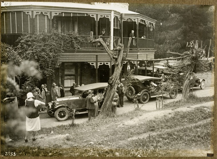
Social life in the “village” revolved around the Mundaring Weir Hall (built in 1908) and the local school. Weekly socials, dances, and “Art Unions” were common, providing a sense of community for the families of the Water Authority workers stationed at the Weir. Tourism peaked with the introduction of Sunday excursion trains in 1907, which brought thousands of “picnickers” from the city to enjoy the landscaped Weir Gardens and view the overflowing dam.31 32 33 34
Environmental Impacts (1916–1930s)
The existence of the reservoir placed Mundaring at the centre of early environmental politics. To maximize water runoff into the weir, vast tracts of the surrounding Jarrah forest were ringbarked in the early 20th century. This practice was highly controversial among local settlers and was eventually challenged by the rise of scientific forestry.35
In 1916, Charles Lane Poole was appointed Conservator of Forests and began implementing the Forests Act 1918 to manage timber resources more sustainably. His successor, Stephen Kessell, established the Mundaring Working Circle in 1926, with forestry headquarters located at the Weir. Fire watch towers were built at Gungin Gully and Mount Dale, providing the district with its first professional fire protection services—a vital necessity for the fruit growers and residents of the hills.36
Wartime and the Raising of the Wall (1940–1951)
During World War II, the Mundaring Weir was recognized as a critical enemy target. Guards were posted at the dam, the hotel’s roof was painted a dark camouflage colour, and an air raid shelter was constructed for the village residents.37 38
Economically, the post-war era brought further expansion. In 1947, the government began work to raise the height of the weir wall by nearly 10 metres to treble its capacity, a project completed in November 1951. This expansion was driven by the need to supply water to a growing population and new agricultural areas under Soldier Settlement Schemes.39
Decline of the Railway and Modern Transformation (1952–Present)
The mid-20th century marked a significant shift in Mundaring’s social and economic structure. As motorcars became more affordable, the reliance on rail transport diminished. The Mundaring Weir branch railway was closed in December 1952, and the entire Mundaring branch line ceased operations in January 1954. The era of the steam-driven picnic train came to an end, and Mundaring began its transition into a “dormitory” town for Perth commuters seeking a rural lifestyle.40 41 42
The timber industry also contracted, leaving smaller-scale firewood cutters and charcoal burners to operate in the thinned forests. In 1954, the electrification of the pumping stations began, eventually leading to the decommissioning of the original steam-powered No. 1 Pumping Station. Recognizing its historic value, the National Trust reopened the station as the C.Y. O’Connor Museum in 1964.43 44
In the 21st century, Mundaring has faced new environmental challenges. Climate change has seen rainfall in the South West decline by up to 20 per cent since the 1970s, with streamflow into dams dropping by a staggering 80 per cent. The Weir, which once overflowed regularly, has not spilled since 1996. To ensure the continued supply of water to the Goldfields, a new modern water treatment plant and pumping station were commissioned in March 2014, allowing for the treatment of artesian water pumped from the Gnangara Mound.45 46
Legacy and Heritage
Today, the Mundaring Weir and its village precinct are preserved as sites of “exceptional significance”. The locality remains a popular destination for nature-based tourism, featuring the Bibbulmun Track and the Railway Reserves Heritage Trail. The Golden Pipeline Heritage Trail, established in 2003, continues to educate visitors on the “audacious” engineering feat that defined the region. While the industrial noise of the sawmills and the steam of the construction trains have faded, Mundaring continues to serve its original purpose: a vital link providing life-sustaining water to the arid heart of Western Australia.47
Timeline
- Pre-European Settlement: The area was part of the traditional lands of the Whadjuk Noongar people, who moved between the coastal plains and the forest. The locality’s name is derived from the Aboriginal word “Mundaring,” which is believed to mean “a high place on a high place”. Evidence suggests the forest below the Weir was used as a camping ground.
- 1829: Ensign Robert Dale became the first European to explore the region, subsequently naming the Helena River.
- 1840s–1870s: European activity was primarily focused on hardwood timber extraction (Jarrah and Wandoo) and road maintenance. Convict road parties maintaining the route to York often camped in the area during the 1870s.
- 1855: The Travellers’ Inn (later known as Horton’s Half-Way House) was constructed near Manaring Lake to serve settlers moving through the district.
- 1882: Peter Gugeri established the “St Bernards” vineyard and orchard approximately two kilometres south of the current township.
- 1884: The arrival of the Eastern Railway at Chidlow’s Well began to diminish the importance of the old York Road inns.
- 1889–1890: The establishment of William Sexton’s sawmill led to the creation of a railway stopping place known as Gugeri’s Siding.
- 1893: The Jacoby family purchased Gugeri’s property, renaming it the Mundaring Vineyard.
- 1894: Gugeri’s Siding was officially renamed Mundaring.
- 1896: Estimates for a Goldfields Water Supply Scheme, designed by Chief Engineer C.Y. O’Connor, were approved by the Western Australian Parliament.
- 1898:
- Work on the Mundaring Weir concrete wall began in April.
- The Mundaring townsite was formally gazetted on 20 May.
- A spur railway line was constructed from the Mundaring township to the Weir site to transport construction materials and workers.
- The original railway station was closed and replaced by a new Mundaring Station in a more central location on 11 July.
- 1899:
- The Mundaring Hotel was established by John Frank and Harold Hummerston, becoming the district’s social hub.
- Construction began on the Mundaring Weir Hotel.
- 1902: The concrete weir wall was completed, but the project was marked by tragedy when C.Y. O’Connor committed suicide in March.
- 1903: The Goldfields Water Supply Scheme was officially opened, and water reached Kalgoorlie in January.
- 1905: Construction of the Mundaring Weir School and Quarters was completed around this time.
- 1907: Regular picnic trains began running from Perth to the Weir, which had become a major tourist destination.
- 1908: The Mundaring Weir Hall (originally a Mechanics’ Institute) was constructed.
- 1909–1913: A timber tramway operated from Paulls Valley to the Weir to transport sawn timber for rail transport.
- 1915: The hills’ reputation as a “healthy retreat” for those with respiratory issues led to the establishment of the Wooroloo Sanatorium.
- 1926: The Mundaring Working Circle was established, with forestry headquarters located at the Weir to manage the surrounding jarrah forest.
- Late 1940s: Work commenced to raise the height of the weir wall to increase the reservoir’s capacity.
- 1951: The raising of the Weir wall was completed in November, effectively trebling its capacity.
- 1952: The Mundaring Weir branch railway was closed to traffic in December.
- 1954: The entire Mundaring branch line was closed in January. Electrification of the pumping stations began this same year.
- 1964: The decommissioned No. 1 Pumping Station was reopened by the National Trust as the C.Y. O’Connor Museum.
- 1971: The Lower Helena Pipehead Dam was completed downstream from the main Weir.
- 1996: The Mundaring Weir overflowed for the last time to date48.
- 2003: The Golden Pipeline Heritage Trail, a self-guided drive interpreting the history of the scheme, was developed by the National Trust.
- 2004:
- The Mundaring Weir Hotel was officially added to Western Australia’s Heritage Register.
- The Helena River Reservoir was officially renamed Lake C.Y. O’Connor.
- 2014: A new water treatment plant and modern pumping station commenced operations in March to address declining water quality and climate change impacts.
- 2016: The Mundaring Hotel was officially added to Western Australia’s Heritage Register.
Map
Sources
- State Library of Western Australia (1936). John K Ewers collection of photographs; BA1658/256-270. Retrieved 17 Mar 2026 from https://encore.slwa.wa.gov.au/iii/encore/record/C__Rb3388417 ↩︎
- National Trust of Western Australia (n.d.) The Golden Pipeline: Mundaring. Retrieved 17 Mar 2026 from https://www.goldenpipeline.com.au/place/mundaring/ ↩︎
- Mundaring & Hills Historical Society (2021). Mundaring. Retrieved 17 Mar 2026 from https://www.mundaringhistory.org/mundaring-shire-localities ↩︎
- Mills, Jenny (2010). Weir Valley Farm, Mundaring, Western Australia: land in transition. Proceedings of the Eighth National Conference on Australian Forest History. Brett J. Stubbs et al. (ed.). © 2012, ISBN 978-0-9757906-2-5 Retrieved 31 Mar 2026 from https://www.foresthistory.org.au/2010_conference_papers/Mills%20Paper.pdf ↩︎
- Wikipedia (2020). Mundaring Weir. Retrieved 17 Mar 2026 from https://en.wikipedia.org/wiki/Mundaring_Weir ↩︎
- Mills (2010): p.3 ↩︎
- Heritage Council of WA (2017). Travellers’ Inn Ruins. Retrieved 17 Mar 2026 from https://inherit.dplh.wa.gov.au/public/inventory/details/02f2be09-9790-45ec-99a6-2780f0b9e570 ↩︎
- ibid ↩︎
- Mundaring & Hills H.S.: refers to early development ↩︎
- National Trust of WA: refers to establishment of Gugeri’s Siding ↩︎
- Heritage Council of WA (2019). Mundaring Saw Mill. Retrieved 18 Mar 2026 from https://inherit.dplh.wa.gov.au/public/inventory/printsinglerecord/86846843-6c8a-47b2-8de1-3e9094aeda4e ↩︎
- Mills (2010): p.3 ↩︎
- ibid: p.5 ↩︎
- NEWS AND NOTES. (1897, October 14). The West Australian (Perth, WA : 1879 – 1954), p. 4. Retrieved March 31, 2026, from http://nla.gov.au/nla.news-article3185750 ↩︎
- Wikipedia (2020): refers to C. Y. O’Connor ↩︎
- Heritage Council of WA (2022). Mundaring Weir, Gardens and Village Precinct. Retrieved 19 Mar 2026 from https://inherit.dplh.wa.gov.au/Public/Inventory/Details/b16aaa2c-70cb-438c-ac87-dfb319ea26fc ↩︎
- National Trust of WA: refers to goldfields water supply ↩︎
- Wikipedia (2017). Mundaring Hotel. Retrieved 19 Mar 2026 from https://en.wikipedia.org/wiki/Mundaring_Hotel ↩︎
- National Trust of WA: refers to the choice of site for the weir ↩︎
- Wikipedia (2020): refers to the construction of the spur line ↩︎
- Heritage Council of WA (2022): refers to the construction of the spur line ↩︎
- Shire of Mundaring (2026). Our History and Heritage. Retrieved 19 Mar 2026 from https://www.mundaring.wa.gov.au/shire-council/about-our-shire/our-history-and-heritage.aspx ↩︎
- Mills (2010): p.7 ↩︎
- State Library of Western Australia (n.d.) Golden Pipeline Project. Retrieved 18 Mar 2026 from https://encore.slwa.wa.gov.au/iii/encore/record/C__Rb2193542 ↩︎
- Heritage Council of WA (2022): refers to C. Y. O’Connor ↩︎
- Wikipedia (2020): refers to C. Y. O’Connor ↩︎
- National Trust of WA (n.d.) The Golden Pipeline: Charles Yelverton O’Connor. Retrieved 19 Mar 2026 from https://www.goldenpipeline.com.au/the-people/cy-oconnor/ ↩︎
- The Mundaring Hotel (n.d.) Welcome to the Mundaring Hotel. Retrieved 19 Mar 2026 from https://www.mundaringhotel.com.au/about-us/ ↩︎
- Mundaring Weir Hotel (n.d.) Mundaring Weir History to Today. Retrieved 19 Mar 2026 from https://www.mundaringweirhotel.com.au/hello-world/ ↩︎
- State Library of Western Australia (n.d.) Photographs of the West; BA1913/1/48. Retrieved 18 Mar 2026 from https://encore.slwa.wa.gov.au/iii/encore/record/C__Rb2611094 ↩︎
- Heritage Council of Western Australia (2016). Mundaring Weir Hotel. Retrieved 19 Mar 2026 from https://inherit.dplh.wa.gov.au/Public/Inventory/Details/4e6dd491-3cdb-4572-a839-a86fa2fe5c08 ↩︎
- Mundaring Weir (1910, April 1). The Swan Express (Midland Junction, WA : 1900 – 1954), p. 3. Retrieved March 19, 2026, from http://nla.gov.au/nla.news-article204780029 ↩︎
- MUNDARING WEIR. (1910, December 23). The Mirror (Perth, WA : 1907 – 1910), p. 4. Retrieved March 19, 2026, from http://nla.gov.au/nla.news-article257358536 ↩︎
- MUNDARING WEIR (1930, July 24). The Advertiser (Fremantle, WA : 1921 – 1932), p. 2. Retrieved March 19, 2026, from http://nla.gov.au/nla.news-article255958930 ↩︎
- Mundaring Weir. (1906, September 8). The Swan Express (Midland Junction, WA : 1900 – 1954), p. 3. Retrieved March 19, 2026, from http://nla.gov.au/nla.news-article207335024 ↩︎
- Mills (2010): p.8 ↩︎
- Heritage Council of Western Australia (2016). WWII Air Raid Shelter, Mundaring Weir. Retreived 19 Mar 2026 from https://inherit.dplh.wa.gov.au/Public/Inventory/Details/4807b574-2ca2-444c-9d15-c3ba03da8d32 ↩︎
- Mundaring Weir Hotel: refers to wartime defences ↩︎
- RAISING WALL AT MUNDARING WEIR (1950, April 29). The West Australian (Perth, WA : 1879 – 1954), p. 2. Retrieved March 19, 2026, from http://nla.gov.au/nla.news-article47844548 ↩︎
- Signalling Interest Group of Western Australia (n.d.) Mundaring. Retrieved 19 Mar 2026 from https://www.sigwa.info/mundaring.html ↩︎
- National Trust of WA: refers to “dormitory” town ↩︎
- Wikipedia (2020): refers to the closure of the railway ↩︎
- Heritage Council of Western Australia (2019). Chidlow Saw Mills. Retrieved 20 Mar 2026 from https://inherit.dplh.wa.gov.au/Public/Inventory/Details/7801b3e3-ab03-48da-b52e-cf9713ef577c ↩︎
- Wikipedia (2020): refers to C Y O’Connor Museum ↩︎
- Logan, Tyne and Rimrod, Fran (2025). ABC News: Perth had its wettest winter in 30 years. Why aren’t its dams full? Retrieved 20 Mar 2026 from https://www.abc.net.au/news/2025-09-14/perth-dam-remains-low-despite-the-wettest-winter-in-30-years/105767386?utm_campaign=abc_news_web&utm_content=link&utm_medium=content_shared&utm_source=abc_news_web ↩︎
- Wikipedia (2020): refers to new pumping station and water treatment facilities ↩︎
- Heritage Council of Western Australia (n.d.) List of heritage listed sites in Shire of Mundaring. Retrieved 20 Mar 2026 from https://inherit.dplh.wa.gov.au/Public/Search/Results?newSearch=True&placeNameContains=Mundaring&streetNameContains=&suburbOrTownContains=&lgaContains=&isCurrentlyStateRegistered=false ↩︎
- Note: as at March 2026 ↩︎
Further Reading
- Anon., 1897. Records of Mundaring Vineyard Co. Ltd., Battye Library, State Library of Western Australia, M.N. 2217, Acc. 6010A.
- Elliot, Ian (1983) Mundaring. A History of the Shire. SLWA Call No. 994.11/MUN
- Evans, A.G. (2001) C. Y. O’Connor His Life and Legacy (Crawley, WA: UWA Press)
- Ewers, John K (1936). The story of the pipe-line : being an account of the construction of the Coolgardie water scheme with some chapters on the early history of Western Australia. SLWA Call No. 994.1 EWE.
- Host, J. and Owen, C. 2009. ‘It’s still in my heart, this is my country’ The Single Noongar Claim History (Crawley, WA: UWA Press).
- Mills, J. 1989. The impact of man on the northern jarrah forest from settlement in 1829 to the Forest Act 1918. In Dell, B., Havel, J. J. and Malajczuk, N. (ed.), The Jarrah forest: a complex Mediterranean ecosystem (Dordrecht: Kluwer Academic Publishing), 256–261.
- Moore, G. F. 1884. Diary of Ten Years Eventful Life of an Early Settler in Western Australia and also A Descriptive Vocabulary of the Language of the Aborigines (London: M. Walbrook).
- Tauman, M., 1978. The Chief, C. Y. O’Connor (Nedlands, WA: University of Western Australia Press).
- Tie, M. 2000. Jacoby Women of Mundaring. In Mundaring Hills Historical Society, Patchwork of Memories: the story of women in Mundaring whose lives made a difference (Sawyers Valley, WA: Bruce Publishing), 40–42.
