Region: Wheatbelt
LGA: Shire of Wandering
Industry: Farming
Coordinates: 32° 36′ 47.41″ S, 116° 54′ 21.51″ E
What3Words: //regionals.grasped.carnation
Population: 0
Started:
Gazetted:
Closed:
Neta Vale comes under the Wandering Roads Board and is on the South Wandering Road slightly south of the crossroads of the South Wandering Road and the York Williams Road. 6 1/2 miles (10kms) North on the York Williams Road is the town site of Taylors Well, and 3 miles South is Pumphreys Bridge. To the East 12 miles on the South Wandering road is the town of Pingelly, and 13 miles West is the town of Wandering, being the oldest settlement in the district2.
The Shire of Wandering3 gives us some of the history of Neta Vale:
John Jules Parker on leaving the goldfields around 1905 first owned the land Neta Vale was established on. It’s believed he named this farm after his youngest Daughter Annie Juanita Parker. Then by Reginald Thomas Parker was the next owner and farmed it until the 1960s.
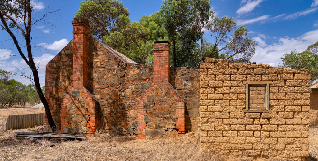
The house that John Jules built on his block was brought down form the goldfields. This was a weatherboard and iron building consisting of two bedrooms, a lounge room and kitchen, front and back verandahs. The front verandah was bullnosed, a Sleepout was included on the east side of this verandah in later years. The west wall made of local stone so it could house the chimneys needed for the kitchen cooking stove, and the open lounge fireplace. Bath time or bath night was in a large galvanised tub wiht the cleanest having the first bath and the dirtiest the last bath. A bathroom was also added later. A wash house or laundry if it could be called that was only a lean to on the east side of the house, with the laundry being done with wash board and large galvanised tub, or tubs and a kerosene tin balance on iron bars over a fire for boiling the clothes. The lavatory as the toilet was known as in those days was a stone building with a pan system with a small opening at the back to make the emptying of the pan easy, this building was out the back near the chook run. In later years a mud bat bathroom was added to the West End of the back verandah, and later again a plush toilet added to the other end of the back verandah.
The Neta Vale property had all the usual farm buildings of that era such as horse stables, cow shed, chaff house, feed shed and a machinery shed which was a long building with thatched roof for the first shearing shed was in this building with the new larger shearing she being added in later years. This farm was virgin land when taken up by the John Jules, and as the original 160 acres was not enough land to make a substantial living more land was added as time went by with the next generations Reg and Jack, also having to do their share of clearing to increase their land.
At some stage a Party line Telephone Exchange was included in the lounge room known as the Neta Vale Exchange, first run by Annie Parker then by Agnes Parker wife of Reginals, with a telephone box under the front verandah. When the Dattening Telephone Exchange closed down, the subscribers were then connected to the Neta Vale Exchange on the party line. Some of the early neighbours to this farm were the Darcy, Ward, McGinty, Hughes, Crommelin, Bostock, Watts and Ambrose Families.
This farm has now been broken up into hobby farms and sold.
Sources
- Barry Lodge, 2024. Neta Vale Telegraph Station. Image retrieved from https://www.abalook.com/new-blog/2024/1/7/52-photos-wk01neta-vale-telegraph-station on 16 Oct 2024 ↩︎
- Shire of Wandering, n.d. Neta Vale. Retrieved on 16 Oct 2024 from https://www.wandering.wa.gov.au/discovering-wandering/about-wandering/neta-vale.aspx ↩︎
- Shire of Wandering, n.d. Neta Vale. Retrieved on 16 Oct 2024 from https://www.wandering.wa.gov.au/discovering-wandering/about-wandering/neta-vale.aspx ↩︎
