Region: Wheatbelt
LGA: Shire of Dowerin
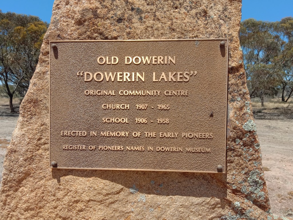
AKA: Dowerin (until 1906), Old Dowerin
Industry: Agriculture
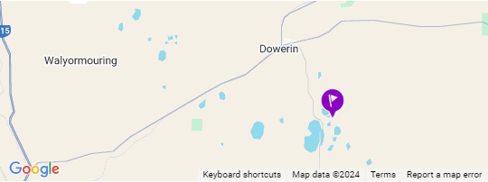
Coordinates: 31°15’53.0″S 117°03’31.5″E
What3Words: ///kayak.footage.drumbeat
Population: unknown
Settled: 1895
Closed: ~1906
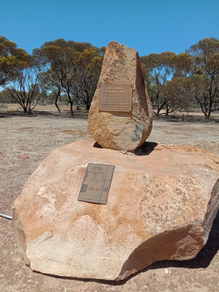
The name of the Shire and the town site of Dowerin is derived from the aboriginal word Daren given to a series of lakes once fresher, some 8-10 kilometres south of the town. It was originally established as a watering hole and resting place for prospectors and travellers on their way to the goldfields. It was first settled in 1895, but the railway in 1906 was unable to be built in the area and as a consequence, the town site was moved to the present site. There is a brass plaque marking the spot where the original town reserve once stood1,2.
The following statistical information concerning the Dowerin district was compiled (in 1922) by Mr. S. Griffiths, Secretary of the Dowerin Road Board, for the use of the Tourist and Publicity Bureau, Perth. It was published in the Northam Advertiser as an interesting indication of the great progress Dowerin achieved during the period from 1914 to 19224:
Dowerin township is situated on the Dowerin-Merredin railway, 111 miles from Perth and 81 miles from Northam. It is the center of an extensive and prosperous agricultural area, with an elevation of 590 feet above sea level. The population of the township is over 200, and the Dowerin Road Board District has about 1,100 residents. The railway was extended from Northam to Dowerin and opened for traffic in 1900. Soon after, many businesses were established, including general stores, blacksmiths, wheelwrights, saddlers, a hotel, and a hostel. Many substantial public buildings have been erected, such as a Public Hall, Post Office, State School, Police Station, and Anglican Church.
At present, the township’s housing capacity is being increased by several homes authorized by the Workers’ Homes Board. The water supply, apart from drinking water, is obtained from surface tanks with a capacity of over 4,000 cubic yards, lifted into town receivers by a windmill.
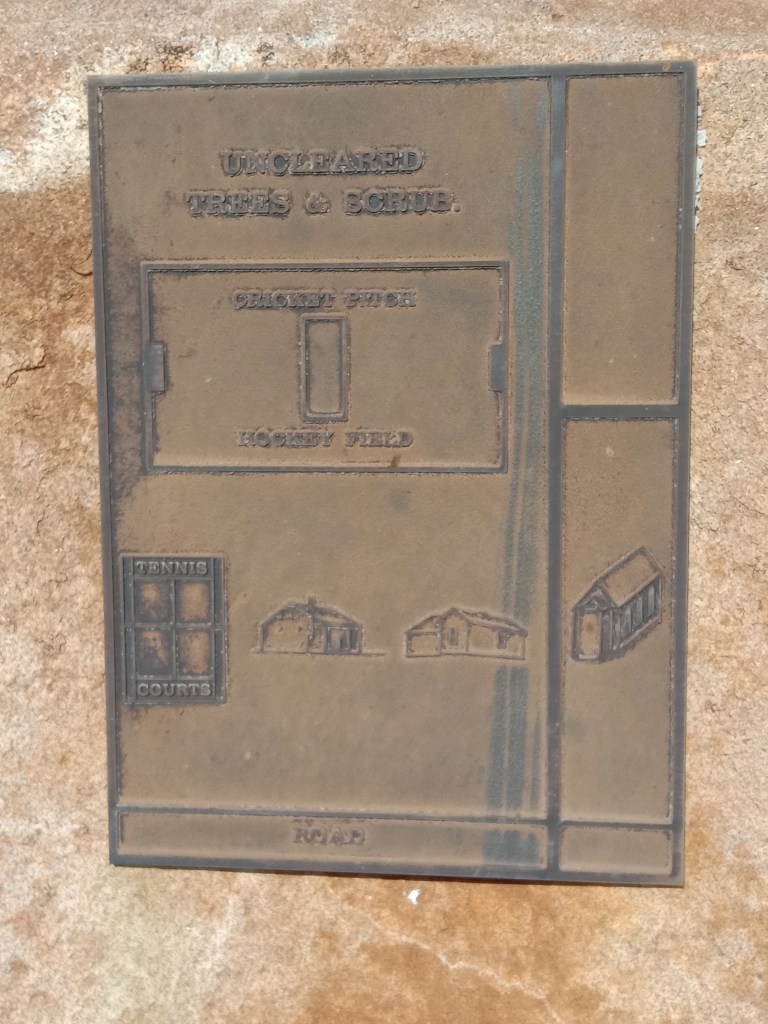
The Dowerin district includes localities such as Old Dowerin, Goomalling, Hindmarsh, Ejanding, Koorrberkine, Nambling, Booralaming, and Minnivale. Public halls are located in Hindmarsh, Booralaming, and Minnivale. Old Dowerin also has a Methodist Church.
The railway sidings within the district are located at Nambling, Dowerin, Ejanding, and Minnivale, the latter being a rising and important center. The rainfall for Dowerin was 16.9 inches in 1921, with an average of 14 inches over seventeen years. Initially known for wheat production, the district now produces wheat, wool, stock, and cream. Between 1913 and April 1922, the railway transported 90,008 tons of wheat, 266 tons of wool, and 8,207 tons of general goods, along with 107 horses, 69 cattle, 101 calves, 6,276 pigs, and 21,040 sheep. There has been a notable increase in livestock, leading to the construction of a machine shearing depot in 1918. Between 1918 and 1921, 61,780 sheep were shorn at the depot by 22 local farmers.
The district is well supplied with educational facilities, having five Government schools within the Road Board area. Banking services are provided by the Commonwealth and State Savings Banks, along with the National and Commercial Banks. Mails are delivered from the Post Office at Dowerin and Minnivale via motor transport to surrounding localities.
The Road Board has focused on improving district infrastructure, with £12,522 spent on road development since 1913. Agricultural development is promoted by the Agricultural Society, which holds an annual show. In the near future, this show is expected to become the leading one in the Eastern Wheat Belt. Amusements are provided by local clubs for racing, tennis, football, and cricket.
Most of the forest land in the district has been cultivated, but an extensive area of light, plain land remains unselected. With suitable equipment and proper cultivation, this land could be highly productive and serve as valuable security for public investments.
The quality of the land in Dowerin cannot be fully appreciated from a railway journey, as the line passes through some of the poorer sections. However, just two miles from the tracks lie stretches of forest land under cultivation, where many prosperous families have established themselves in substantial and comfortable homes. Much of the district’s progress can be attributed to its early pioneers, who recognized the land’s potential and encouraged others to join them in its development. Notable pioneers include Stephen Couper (Sr. and Jr.), J. R. Stewart, J. S. and C. S. Anderson, E. W. Cottrell, W. Fraser, H. B. Jones, W. Place, G. Hatwell, J. Hatwell, R. W. J. McHugh, C. H. Hayter, G. Meldrum, G. Farmer, J. C. Watson, J. and T. Evans, and R. G. Stewart.
Mr. J. S. Anderson was the first settler in the district, having resided there for over 15 years. Wheat was first grown in the Dowerin area in 1901 by Messrs. Couper, Place, Fraser, Hayter, and J. R. Stewart. The first harvest was carted to Northam and Hulongine Stations.
In 1928, The West Australian newspaper interviewed Mr J. F. Anderson5:
He shared that he arrived in the district in September 1897, having driven from Northam. He was among the first men in the district, but before him were Mr. S. Cooper and Mr. W. Place. Both men had come from the goldfields and brought a team of horses to what is now known as Old Dowerin.
Their first crop, grown in 1899, was cut for hay. Along with other pioneers in the district, they carted their first wheat crop to Northam, and several crops were taken to Goomalling before the railway was extended to Dowerin in 1906-1907. Once Dowerin became the terminus of the railway, the district received a significant boost, and its development progressed steadily. Settlements like Wyalkatchem and Cowcowing were established from Dowerin.
Mr. Anderson recalled that he received 2/10 per bushel for his early crops, while last season, the average return to farmers in the district was 4/10 per bushel. He noted that scientific farming had greatly impacted the district, as the ratio of sandplain to first-class land was about two acres to one. Scientific farming had allowed large areas of land, once thought to be useless, to be successfully cultivated.
The first article refers to a J. S. Anderson while the second refers to a J. F. Anderson. Neither article indicates that there were two Mr Andersons. So which is correct?
Sources
- WikiCamps Australia, n.d. Old Dowerin – Original Town Site. Retrieved from https://wikicamps.com.au/site/Western%2BAustralia/Point+of+Interest/Old+Dowerin+-+Original+Town+Site/54645 on 15 Oct 2024. ↩︎
- Shire of Dowerin, n.d. History and Heritage- Dowerin Lakes & Old Dowerin. Retrieved from https://www.dowerin.wa.gov.au/tourism/history/history-heritage.aspx on 15 Oct 2024 ↩︎
- Diane Hatwell, 2024. Series of photographs taken on the site of Dowerin Lakes, aka Old Dowerin, 27 Oct 2024. ↩︎
- DOWERIN AND ITS ENVIRONS. (1922, September 2). The Northam Advertiser (WA : 1895 – 1955), p. 4. Retrieved October 23, 2024, from http://nla.gov.au/nla.news-article260184119 ↩︎
- PIONEERS’ TALES. (1928, October 23). The West Australian (Perth, WA : 1879 – 1954), p. 14. Retrieved October 23, 2024, from http://nla.gov.au/nla.news-article32232135 ↩︎
