Christine Harris (2026)
Demographics
Region: Mid West
LGA: Mount Magnet
Industry: Mining
Other Names: East Mount Magnet, Fords, Paynton
Open Street Map: -27.81728562873941, 118.56164524929383
What3Words: ///something.paler.interactions
Settled: 1898
Gazetted: 1900
Closed: 1949
Abstract
This article provides a historical exploration of Paynesville, an abandoned gold rush town in Western Australia’s Mid West region. Originally known by provisional names such as Paynton, East Mount Magnet, and Fords, the community was officially gazetted in 1900, taking its name from pioneering prospector Thomas Payne. Following Payne and Arthur Waldeck’s initial discovery of alluvial gold in early 1898, the field briefly thrived as prospectors flocked to the Murchison Goldfield. The article examines the unique geology of the sixty-kilometre greenstone belt and the erratic quartz reefs that dictated the town’s economic fortunes. To support the boom, a Progress Committee lobbied for early services, resulting in the establishment of a Board of Health, a windmill well, and a local hotel. A government ore battery was built in 1900, but declining yields forced its removal to Nunngarra in 1904. The opening of the Sandstone branch railway in 1910 provided a temporary lifeline, but agricultural and prospecting revivals in the 1920s and 1930s ultimately failed to sustain the settlement. The closure of the railway in 1949 and its removal in 1950 marked the final stage of decline. Today, the quiet outback townsite is completely uninhabited, leaving behind scattered foundations, concrete battery ruins, and five poignant graves in Reserve 6674 that commemorate the human toll and hazards of frontier life on this remote Australian goldfield.
History
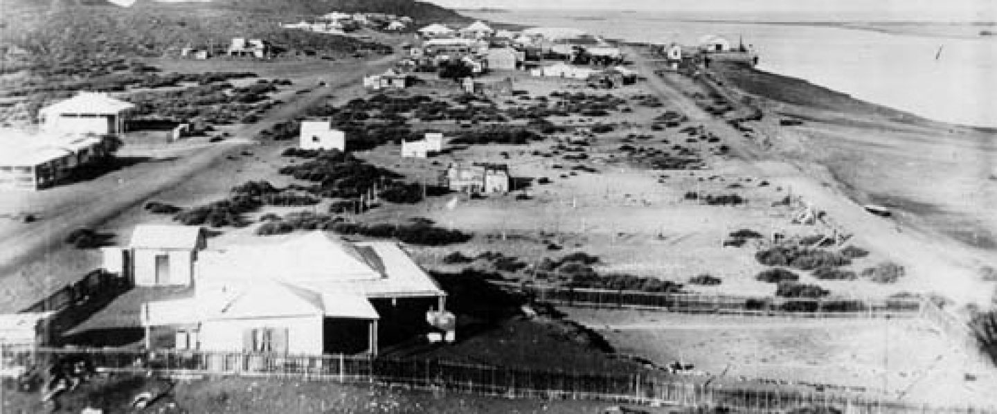
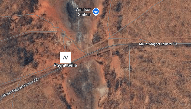
Paynesville is located 77 kilometres east of Mount Magnet along the Mount Magnet-Sandstone Road, and some 646 kilometres northeast of Perth. This abandoned townsite was once a scene of vibrant activity and high expectations. In its early days, the burgeoning community was known by several provisional names, including Paynton, East Mount Magnet, and Fords, the latter commemorating a prospector who had worked the ground during the initial rush. Despite these shifting identities, the name Paynesville was adopted in honour of Thomas Payne, the experienced prospector who, with partner Arthur Waldeck, set off the rush that established the settlement. Today, the townsite is almost forgotten, reclaimed by the mulga woodlands and acacia scrub of the Murchison bio-region. However, the records of Paynesville offer a rich window into the lives of the individuals who dared to tame this rugged frontier.
The Rush of 1898
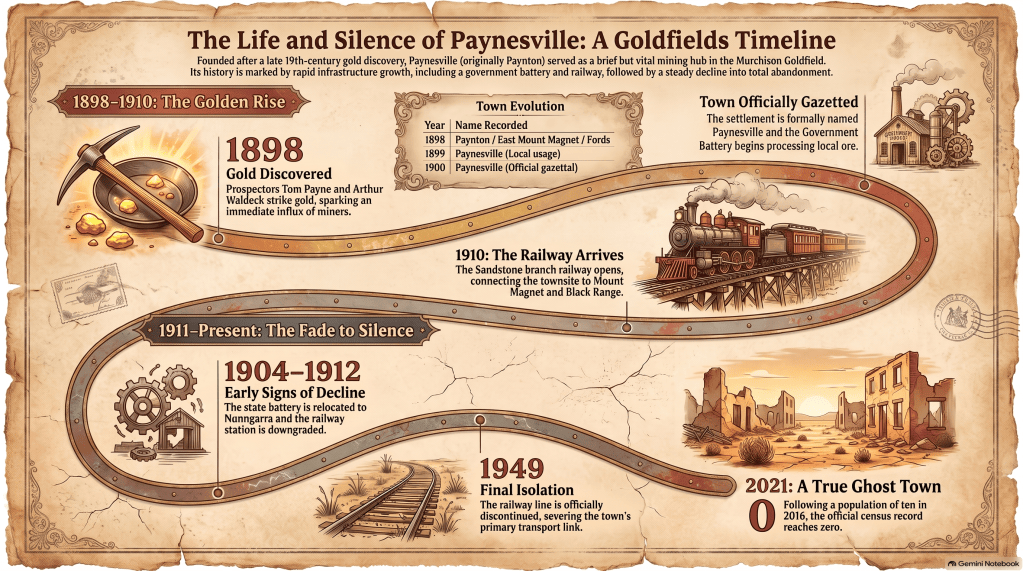
The history of Paynesville commenced in early 1898 during a period of rapid expansion across the Murchison Goldfields. Following discoveries at Cue in 1891 and Mount Magnet in 1895, prospectors pushed further east into the dry interior in search of alluvial deposits. It was in late 1897 that Thomas Payne and Arthur Waldeck first pegged a protection area in the district, seventy seven kilometres east of Mount Magnet. Initially, surface prospecting yielded only minor indications, but their persistence was rewarded in early 1898 when they struck payable alluvial gold at a shallow depth of four feet on their South Australian protection area.1
The deposit consisted of coarse, unworn gold nuggets, indicating that the source reef was close at hand. The largest recorded nugget from their initial find weighed one ounce. Using basic surfacing techniques, such as dry-blowing machines and shakers to separate the precious metal from the dry, gravelly soil, the pioneers quickly demonstrated the richness of the field. News of the strike spread rapidly, triggering an immediate rush. Within weeks, forty to fifty diggers had arrived on the field, each recovering modest but consistent amounts of gold. This initial alluvial patch, which was later formalised as part of the adjacent Lady Maud lease, established Paynesville as a promising new centre of mining activity.2
Thomas Payne, of Paynes Find fame, was an archetype of the itinerant prospector. His partner, Arthur Waldeck, belonged to a prominent local family that owned the nearby Walgetharra pastoral station. This connection proved invaluable, enabling the family to provide crucial logistical support, fresh water, and meat to early miners arriving in this isolated environment. 3
The Paynesville Goldfield
The economic fortunes of Paynesville were dictated by its unique geological setting near the northern edge of a massive greenstone belt, 60 kilometres long and 30 kilometres wide. The country rock consists of massive epidiorite derived from ancient gabbro or quartz dolerite, forming part of the Yilgarn Craton. This greenstone belt is intruded by quartz porphyry dykes, which rise conspicuously from the flat plains to form steep, rugged hills serving as landmarks for early prospectors.4
Geological reports, notably by F. R. Feldtmann in 1924, revealed that the porphyry magma had dissolved portions of the greenstone, forming patches of chlorite schist that gave the rock a fragmented appearance. Along the contacts where the dykes intruded the greenstone, intense movement formed brecciated jasper, subsequently re-cemented by veins of auriferous quartz.
Mining targeted narrow, sheared quartz veins and reefs. The gold occurred in erratic, rich patches rather than in uniform lodes, a factor that heavily influenced the town’s long-term survival. Workings were divided into several main systems. The principal group was the Lady Maud line north of the townsite, extending diagonally through the main leases. The quartz and adjacent schist of the Lady Maud reefs were heavily pyritised, with pyrite forming imperfect cubes up to half an inch across. Another major system was the Christmas Gift line, represented by parallel reefs running through the Christmas Gift lease, G.M.L. 415m, and extending southeast toward the Aftermath lease. Unlike the Lady Maud, the Christmas Gift reefs contained very little pyrite but yielded high-grade ore, including exceptionally rich specimen gold. The Maori line on G.M.L. 414m was another key system producing yields from narrow veinlets of coarse, flat gold between the main reef body and the footwall casing.5
The Rise of a Frontier Settlement
The rapid influx of miners in early 1898 necessitated the immediate establishment of administrative and social infrastructure. By April 1898, a government surveyor had inspected the field and prepared a formal plan of subdivision for the new townsite. To address health challenges in the crowded bush camp, a local Board of Health was established in April 1898 to oversee basic sanitation and waste disposal. Although surveyed in 1898, the townsite was not officially gazetted under the name Paynesville until 1 August 1900.6
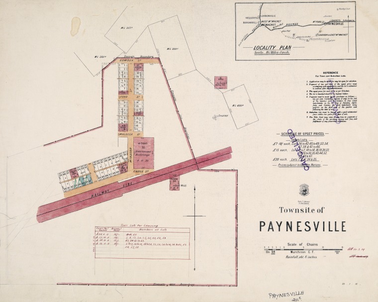
In March 1898, John Walker (chairman), Pierce, Thomas, Blencowe, Priestly, Menzies, and Archibald Morton (secretary) formed a Progress Committee to petition the colonial government. They requested a post office for registered mail, a regular mail service, and a two hundred and fifty pound grant to sink a water well, erect public closets, clear streets, and clear a track to Lawler’s Road to save travellers a considerable distance.
John Walker completed his hotel in March 1898, applying for a wayside licence at the Murchison Licensing Court. Other businesses, general stores, and assay offices followed. A crucial milestone was the construction of a state-owned ten-stamp ore battery; work was underway by February 1899, and it opened in November 1900 as the Paynesville Government Battery. This facility allowed prospectors to crush ore locally. However, local production soon declined, and by early 1904, the battery fell into disuse. The plant was dismantled and relocated eighty kilometres east to Nunngarra, near Sandstone, transported by large teams of horses, donkeys, and bullocks.8
Community Life, Personalities, and Pastoralism
Despite the decline of large-scale mining, Paynesville retained a cohesive community supported by pastoralism and small-scale prospecting. The surrounding semi-arid rangelands, though challenging, proved suitable for sheep and cattle grazing. Several prominent pastoral stations were established in the district, including Wondinong and Windsor Station, the latter located directly west of the townsite.
One notable pioneer was William Nicholas Cock, known as Billie Cock. Born in Moonta, South Australia, in 1870, Billie was educated as a school teacher, but the goldfields drew him to Cue in 1892, putting down the first government well. After prospecting around Yalgoo, he moved to Paynesville, conducting the local hotel and taking up Windsor Station. Billie was described as one of nature’s gentlemen, kind to a fault, who never turned away anyone in need. He eventually sold Windsor Station and moved east, becoming the first white man to set foot on the Sandstone field, where he established Atley, Depot Springs, and Kaluwiri stations.
Other residents maintained the commercial and social fabric. Edward S. Moses operated the hotel, providing a social hub for prospectors and pastoralists. In 1924, Kathleen Kelly was head teacher at the Associated School. The water supply was secured by a government windmill well on Reserve 13,266, which provided excellent water from depths of thirty eight to sixty feet, while another well with windlass and troughs sat on the flat between the town and cemetery.9 10
Modernization in the 1920s was marked by early motor vehicle registrations with the Mount Magnet Road Board. Arthur Simpson registered a thirty horsepower Overland car in 1922, with subsequent Overland registrations by A. G. and A. H. Simpson. Other registered owners included J. Mitchell with a Ford in 1925 and a Graham truck in 1927, A. G. Moses with a Buick in 1924, and E. Harris with a Ford in 1927. These vehicles gradually replaced camel trains and horse teams.11
Stories from the Cemetery
For genealogists and family historians, the most poignant remaining feature of Paynesville is its isolated cemetery, gazetted as Reserve 6674. Situated in a harsh, rocky landscape where grave digging was an incredibly arduous task, the cemetery contains only five recorded burials, with only a single headstone surviving to the present day. These five graves tell a deeply moving story of the dangers, hardships, and realities of life on this remote mining frontier.12
The only grave marked by a headstone is that of Ernest Anton Harbordt, a single twenty four year old miner who died on 11 February 1899. Ernest, the second son of Anton and Annie Harbordt, had lived in Western Australia for three years. While working in the water shaft of the Lady Maud Gold Mine, Ernest was struck on the head by a dislodged rock; his skull was fractured and he died soon after. His death was certified in writing by his friend Archibald Morton, and he was buried by Walter Missingham, witnessed by Thomas Duncan and James F. Ryan. In a touching display of mateship, local miners raised fifteen pounds, a significant sum at the time, to erect an iron railing around his grave.13
Another tragedy occurred on 27 March 1901, claiming thirty three year old Irish miner Timothy O’Regan. Born in Kinsale, County Cork, Timothy was the son of James O’Regan and Elizabeth Kelly. While working in the shaft of the Surprise Lease, Timothy was killed when a rope broke, causing a heavy bucket to fall and crush him. He was buried by Arthur Otto Peck, witnessed by his brother John O’Regan and Thomas Payne.14
The third burial is Ernst Bruno Eiffler, a seventy four year old German carpenter who died of natural causes on 27 December 1915. Born in Gorlitz, Prussia, to Carl Ernst Ferdinand Eiffler and Christiana Charlotte Karuse, he married Mary Agnes Heayney in Melbourne at age thirty two before moving to the goldfields. He left behind five children: Matilda, Selina Bertha, Bruno Ernst, Anna Charlotte, and Minnie. His son, Bruno Ernst, registered the family livestock brand, E1U, in 1924.15 Ernst was buried by A. Johns, witnessed by H. Nicholl and J. Graham.16
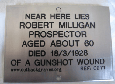
The fourth grave contains Robert Milligan, a Victorian-born prospector aged about sixty, who died on 18 March 1928. Found in his camp with a gunshot wound and a rifle lying beside him on his bed, the coroner returned a verdict of suicide. He was buried by police constable J. Markey of Sandstone, witnessed by A. G. Moses.17
The final burial is James Melville Gardiner Torrance, a fifty five year old gardener who died on 14 April 1935. Born in Edinburgh, Scotland, to William Watson Torrance and Catherine Gardener Mack, James lived in Western Australia for over twenty years. After spending much of his life in the Kimberley region, he suffered from heart trouble and was found dead in bed by Edward S. Moses, licensee of the Paynesville Hotel, who buried him, witnessed by police constable William Walter Hearn.18
The Coming and Going of the Railway
For several decades, the lifeline of Paynesville was the Sandstone branch railway, also known as the Black Range railway. Authorized under the Mt. Magnet-Black Range Railway Act 1907, construction of the forty two mile line commenced in 1909 to connect the goldfields of Sandstone with the main Mullewa-Meekatharra line at Mount Magnet. The railway officially opened on 16 July 1910, with grand celebrations attended by the Governor and Acting Premier, while commercial services commenced on 1 August 1910.19
Paynesville was established as a major stop, situated five hundred and twenty five miles by rail from Perth and forty three miles from Mount Magnet. The station featured a dedicated siding and hosted popular refreshment services under lease. The railway revolutionized life in the isolated community, allowing rapid transport of machinery, timber, water, and livestock, while providing a direct link to coastal ports and metropolitan markets. During dry seasons, the railway was frequently used to haul large water tanks to supply the surrounding pastoral stations and mining camps.
However, the railway’s prosperity was short-lived. Following the decline of the Sandstone goldfields and post-World War II economic austerity, the line fell into disrepair. Faced with a severe shortage of forty five pound rails for repairs and low traffic volumes, the line closed under the Railway Discontinuance Act 1948, taking effect in 1949. The tracks were lifted in 1950, with sleepers and rails salvaged for other state lines or sold. This severed Paynesville’s primary connection to the outside world, accelerating its abandonment.20
Decline, Resurgence, and Final Quiet
The ultimate decline of Paynesville was a gradual process marked by shifting economic realities. The initial gold boom peaked rapidly, and by 1904, the relocation of the government battery to Nunngarra signalled the end of the town’s golden era. While the opening of the railway in 1910 provided a temporary economic boost, the population dwindled as miners migrated to richer fields.21

A minor resurgence in the 1920s and 1930s was driven by small-scale prospecting and pastoralism. A 1924 geological survey renewed interest in the greenstone belt, prompting prospectors to re-examine old leases. Notable operations included the Elsie Mine at Mitchellton, seven miles WSW, which produced three hundred and ninety four ounces of gold from forty eight tonnes crushed in 1927. The Milgoo Mine, worked by one or two individuals, treated over two hundred and twenty tonnes between 1932 and 1939 for a yield of five hundred and twenty seven ounces.
However, these localized successes were insufficient to sustain the community. The onset of the Great Depression in the late 1920s, followed by the outbreak of World War II, restricted investment capital and labour availability. The nearby Youanmi Gold Mine closed, and the local population was evacuated, further isolating the district.
By the second half of the twentieth century, Paynesville had transitioned into a ghost town. The 2016 Australian Census recorded a population of just ten usual residents, evenly split by gender with a median age of fifty seven. By the 2021 Census, the population was officially recorded as zero, marking complete abandonment. Today, only scattered ruins, concrete battery foundations, and the lonely graves of Reserve 6674 remain, silent sentinels in the outback.23 24
Timeline
- 1897: Thomas Payne and Arthur Waldeck peg protection areas and identify early gold indications in the district east of Mount Magnet.
- 1898: Payne and Waldeck strike payable alluvial gold on their South Australian protection area; the townsite is surveyed and a local Board of Health is established.
- 1899: Local prospectors adopt the name Paynesville to honour Thomas Payne; the water shaft at the Lady Maud Gold Mine suffers a fatal rock fall on 11 February, claiming Ernest Anton Harbordt.
- 1900: The townsite is officially gazetted as Paynesville on 1 August, and the Paynesville Government Battery opens in November to process local ore.
- 1901: Irish miner Timothy O’Regan dies in a mine shaft accident on the Surprise Lease on 27 March.
- 1904: The government battery is dismantled and relocated to Nunngarra due to a lack of stone to crush.
- 1910: The Sandstone branch railway line officially opens with a dedicated station and siding at Paynesville, providing a vital connection.
- 1915: Carpenter Ernst Bruno Eiffler dies of natural causes and is buried in the Paynesville Cemetery on 27 December.
- 1924: Field geologist F. R. Feldtmann publishes a detailed geological report on the Paynesville belt; Kathleen Kelly serves as the head teacher at the local school.
- 1928: Victorian-born prospector Robert Milligan dies by suicide in his camp and is buried in the local cemetery on 18 March.
- 1935: Gardener James Melville Gardiner Torrance dies of natural causes at the Paynesville Hotel and is buried on 14 April.
- 1949: The Sandstone branch railway is closed and discontinued under the Railway Discontinuance Act 1948.
- 1950: The railway line is completely lifted, with rails and sleepers salvaged for other state projects.
- 2016: The Australian Census records a tiny, aging population of just ten usual residents remaining in the Paynesville locality.
- 2021: The Australian Census reports a population of zero, marking the complete abandonment of the ghost town.
Map
Sources
- Wiki Australia (2026). Guide to Paynesville. Retrieved 23 Aug 2026 from https://wikiaustralia.com/destination/paynesville/#google_vignette ↩︎
- Hudson Institute of Mineralogy (2026). Paynesville Goldfield, Mount Magnet Shire, Western Australia, Australia. Retrieved 23 Aug 2026 from https://www.mindat.org/loc-264869.html ↩︎
- Sharp, Moya (2017). Paynesville – ghost town. Retrieved 23 Aug 2026 from https://www.outbackfamilyhistoryblog.com/paynesville-ghost-town/ ↩︎
- MINING. (1924, September 23). The Daily News (Perth, WA : 1882 – 1955), p. 8. Retrieved August 23, 2026, from http://nla.gov.au/nla.news-article78438883 ↩︎
- THE PAYNESVILLE GOLD. MINING CENTRE. MURCHISON GOLDFIELD. (1924, October 18). Mount Magnet Miner and Lennonville Leader (WA : 1896 – 1926), p. 2. Retrieved August 23, 2026, from http://nla.gov.au/nla.news-article158216115 ↩︎
- Landgate (2022). Historic Town Names. Retrieved from the Internet Archive on 23 Aug 2026 from https://web.archive.org/web/20220314101618/http://www0.landgate.wa.gov.au/maps-and-imagery/wa-geographic-names/name-history/historical-town-names#P ↩︎
- State Library of Western Australia (1919). Townsite of Paynesville. Cartographic material retrieved on 23 Aug 2026 from https://purl.slwa.wa.gov.au/slwa_b1959576_1 ↩︎
- THE PAYNESVILLE GOLDMINING CENTRE. MURCHISON GOLDFIELD. (1924, November 8). Mount Magnet Miner and Lennonville Leader (WA : 1896 – 1926), p. 2. Retrieved August 23, 2026, from http://nla.gov.au/nla.news-article158216256 ↩︎
- Carnamah Historical Society (n.d.) WA State School Teachers 1900-1980. Retrieved 23 Aug 2026 from https://www.carnamah.com.au/teachers?keyword=Paynesville ↩︎
- Sharp (2017) : Refers to various residents of Paynesville ↩︎
- Carnamah Historical Society (n.d.) WA Motor Vehicle Registrations 1915-1928. Retrieved 23 Aug 2023 from https://www.carnamah.com.au/car-registrations?keyword=Paynesville ↩︎
- Outback Graves Markers (n.d.) Paynesville Search Results. Retrieved 23 Aug 2026 from https://outbackgraves.org/burial-records/burial-search/?Name=&Keywords=PAYNESVILLE&action_OGMSearch=Search ↩︎
- Western Australian Virtual Miners Memorial (n.d.) Ernest Anton Harbordt. Retrieved 23 Aug 2026 from https://www.wavmm.com/?first_name=&last_name=harbordt&mine_location=&wpcf-victims=&post_type=listing ↩︎
- MINING FATALITY. (1901, April 6). Western Mail (Perth, WA : 1885 – 1954), p. 38. Retrieved August 23, 2026, from http://nla.gov.au/nla.news-article33202812
NOTE: Incorrectly reported as Timothy Ryan ↩︎ - Carnamah Historical Society (n.d.) WA Livestock Brands 1912-1962. Retrieved 23 Aug 2026 from https://www.carnamah.com.au/livestock-brands?keyword=Paynesville ↩︎
- Outback Graves Markers (n.d.) Ernst Bruno Eiffler. Retrieved 23 Aug 2026 from https://www.outbackgraves.org/burial-records/person/269 ↩︎
- MAN FOUND DEAD. (1928, March 27). The Daily News (Perth, WA : 1882 – 1955), p. 7 (HOME (FINAL) EDITION). Retrieved August 23, 2026, from http://nla.gov.au/nla.news-article79222463 ↩︎
- Australian Cemeteries (n.d.) Paynesville. Retrieved 23 Aug 2026 from http://www.ozgenonline.com/~australian_cemeteries/wa/mount_magnet/paynesville.htm ↩︎
- Outback Family History (n.d.) Paynesville Western Australia. Retrieved 23 Aug 2026 from https://outbackfamilyhistory.com.au/records/record.php?record_id=487 ↩︎
- Wikipedia (2024). Sandstone branch railway. Retrieved 23 Aug 2026 from https://en.wikipedia.org/wiki/Sandstone_branch_railway ↩︎
- Grokpedia (2025). Paynesville, Western Australia. Retrieved 23 Aug 2026 from https://grokipedia.com/page/paynesville_western_australia ↩︎
- State Library of Western Australia (1933). Le Souef collection 1900s to 1950s; BA1142/27″. Retrieved 23 Aug 2023 from https://catalogue.slwa.wa.gov.au/search/?searchtype=X&SORT=D&searcharg=Boiling+The+Billy+At+Paynesville.+30+May+1933&searchscope=2&submit.x=40&submit.y=20 ↩︎
- Australian Bureau of Statistics (2016). 2016 Census All persons QuickStats. Retrieved 23 Aug 2026 from https://www.abs.gov.au/census/find-census-data/quickstats/2016/SSC51204 ↩︎
- Australian Bureau of Statistics (2021). 2021 Census All persons QuickStats. Retrieved 23 Aug 2026 from https://www.abs.gov.au/census/find-census-data/quickstats/2021/SAL51216 ↩︎
- What3Words (2026). ///something.paler.interactions. Retrieved 23 Aug 2026 from https://what3words.com/something.paler.interactions ↩︎
Versions
| Date | Changes |
|---|---|
| 23 Aug 2026 | Version 0.1 – First draft |
| 6 Sep 2026 | Version 1.0 – First published |

