Christine Harris 2026
Demographics
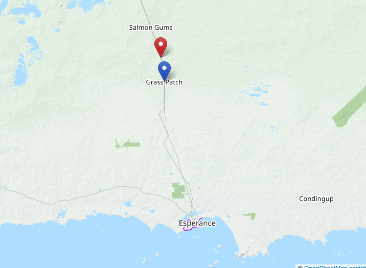
Region: Goldfields-Esperance
LGA: Esperance
Industry: Railway Siding
Open Street Map: -32.802692698543396, 121.70965130711414
What3Words: ///escalator.nosh.planets
Settled: 1916
Gazetted: 1922
Abandoned: 1945
Abstract
Red Lake serves as a poignant example of the ephemeral nature of early 20th-century settlement in the Western Australian Goldfields-Esperance region. Situated approximately 82 kilometres north of Esperance, the town was established as a vital node on the railway line connecting the coast to the goldfields. This article provides a comprehensive historical account of the community, beginning with its traditional ownership by the Kalaako people and its official recording in 1910. It examines the political and economic drivers behind its gazettal in 1922, specifically the expansion of the Western Australian Government Railways and the burgeoning Mallee agricultural industry. The narrative highlights the social heart of the community, the Red Lake Siding School and the Daw family’s general store, and the economic activity evidenced by numerous registered livestock brands. Finally, the article discusses the environmental and economic factors that led to the town’s decline, culminating in the closure of the railway station in 1960 and the subsequent conversion of much of the townsite into the Red Lake Townsite Nature Reserve in 1969. Today, the area is preserved through heritage trails and markers.
History
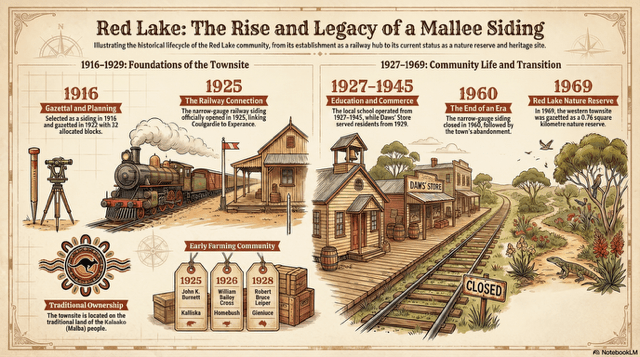
The history of Red Lake, located within the Shire of Esperance, is a story defined by the intersection of political ambition, economic necessity, and the challenging environmental conditions of the Western Australian Mallee. Once a surveyed town with high hopes of becoming a permanent fixture in the Goldfields-Esperance region, it now exists primarily as a memory, a nature reserve, and a stop on a historic trail.1 2
Traditional Origins and Early Selection
Long before the arrival of European surveyors and the construction of the iron road, the land surrounding Red Lake was the traditional home of the Kalaako people. Also known as the Malba or Malpa, a name bestowed upon them by the Wudjari people to their south, the Kalaako managed this semi-arid landscape for generations. The European history of the area began to take formal shape in the early 20th century, with the name “Red Lake” first being officially recorded in 1910 as a descriptive term for a nearby natural feature.3 4
The site’s significance to colonial authorities was primarily logistical. As the state government sought to link the port of Esperance to the eastern goldfields, Red Lake was selected as a siding on the Norseman to Esperance railway in 1916. There was initial political debate regarding the naming of the site; authorities originally proposed the name “Windich” to honour Tommy Windich, the renowned Aboriginal companion of explorer John Forrest. However, local usage prevailed, and the community’s preference for the descriptive “Red Lake” was officially adopted when the townsite was gazetted in 1922.5 6
Planning and Economic Growth
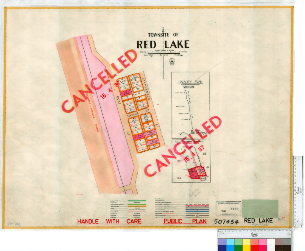
The 1922 gazettal reflected a period of high optimism for the region’s economic potential. Official maps from that year reveal a structured urban design, consisting of a grid with thirty-two land blocks. The town was situated west of the telegraph line and featured north-south thoroughfares named Stephenson and Duke Streets, intersected by the east-west Taylor Street.7
Economic activity in Red Lake was driven by two main pillars: the railway and agriculture. The railway line, lobbied for by residents to provide essential land transport, was an extension of the Eastern Goldfields Railway. The section passing through Red Lake was completed as part of the Salmon Gums to Norseman connection in the mid-1920s. This infrastructure allowed for the transport of goods and the development of local farming.
Historical records of livestock brands from the era demonstrate a high level of agricultural investment in the Red Lake vicinity. Numerous farming families and individuals held properties in the area, including John K. Burnett at Kalliska, E.T. Cooper at Redlands, and William Bailey Cross at Homebush. Other notable settlers who contributed to the local economy included the Hallam, Logan, Longbottom, and Renshaw families. These farmers faced a difficult environment; early railway reports noted that the “dry country” necessitated the construction of significant dams and tanks to supply steam engines, a factor that likely impacted the viability of local farming as well.9 10
Social Infrastructure: School and Store
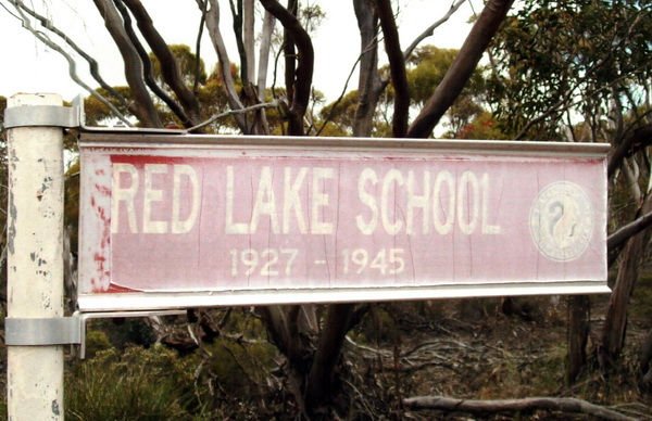
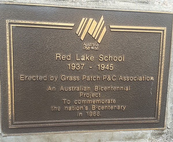
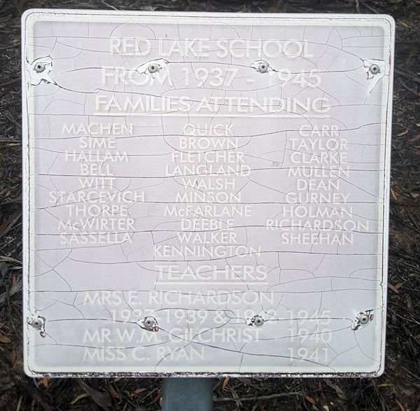
At its peak, Red Lake possessed the essential social infrastructure of a frontier community. The Red Lake Siding School (officially Red Lake Siding VII) served as a vital community hub. From 1937 to 1945, the school was largely led by Head Teacher Ellie Richardson, with other educators like Wm. Gilchrist and Catherine Ryan serving brief tenures during the early years of World War II.11 12 13
Social and commercial life also revolved around the local general store. In 1929, the Daw family moved a small timber and asbestos building from Kundip to Red Lake to serve as a retail outlet. This store was more than a commercial enterprise; it was a gathering place for the scattered farming families of the Mallee. The presence of such facilities suggests a community that, while small, was socially cohesive and politically recognised by the state’s education and postal departments.14 15
In December 1978 Ronda Jamieson for the State Library of Western Australia, interviewed Raymond Clive Daw (then 86 years old). This interview provides a first hand account of his family’s extensive history as pioneering storekeepers in the Esperance region. Born in Maitland, South Australia, Raymond arrived in Esperance in 1895, witnessing the early establishment of the family’s commercial ventures by his father, Francis James Daw. As the region’s agricultural and mining sectors grew, the Daw family strategically expanded their business, operating branches in Ravensthorpe, Grass Patch, Norseman, and Red Lake. Their local involvement even extended to primary production via an orchard at Dalyup.
The Red Lake store was a vital component of this retail network, serving as the primary supply point and social anchor for the isolated farming families of the Mallee. Demonstrating the resourcefulness typical of the era, the family relocated a timber and asbestos building from Kundip in 1929 to serve as the Red Lake storefront. This branch was more than just a retail outlet; it was a central gathering place that facilitated community cohesion in a challenging semi-arid environment.
Raymond’s recollections highlight the family’s adaptability to shifting economic conditions. Following the town’s decline, the Daws transferred their operations to Norseman. The physical legacy of the Red Lake store remains significant; the building was moved to Andrew Street in Esperance in the late 1940s before its final relocation to Museum Park in Esperance in 1973 for preservation. Through Raymond’s interview, the Daw family’s role in sustaining regional outposts like Red Lake is vividly preserved.16 17 18
Decline and Environmental Transition
The eventual decline of Red Lake was the result of shifting economic priorities and the evolving nature of Western Australia’s transport infrastructure. The community’s isolation made it vulnerable to changes in railway operations. The introduction of diesel locomotives in 1954 reduced the need for frequent watering stops in dry country, and the eventual standardisation of the gauge in the 1960s further altered the logistical map of the region.19 20 21
Socially, the community began to shrink as early as the mid-1940s. The school closed its doors in 1945, a common fate for small Mallee schools as populations shifted or consolidated. Not long after, the Daw family transferred their business to Norseman, and the iconic Red Lake store building was transported to Andrew Street in Esperance in the late 1940s. The final blow to the town’s status as a functioning transport node came on 14 March 1960, when the Red Lake railway station was officially closed.22 23 24
By the late 1960s, the political and environmental focus for the area shifted from settlement to conservation. In 1969, the Red Lake Townsite Nature Reserve was gazetted. Occupying 0.76 square kilometres of the western portion of the former townsite, the reserve protects the unique flora and fauna of the Mallee bioregion, effectively returning a large part of the town to its natural state.25
Modern Legacy and Use
Though abandoned as a living town, Red Lake remains a site of historical interest. It is a featured location on the Historic Mallee School Trail, a 166-kilometre heritage route managed by the Esperance Bay Historical Society. Visitors today can find heritage signage and a bicentenary monument plaque marking the site of the former school.
The physical remnants of the town have largely vanished, though the Daw family’s Red Lake Store survives as a heritage asset in a different location. After serving as a real estate office and a doctor’s surgery in Esperance, the building was moved to Museum Park in 1973. It remains there as a testament to the resilient, if transient, timber and asbestos structures that once defined Red Lake.27
Red Lake’s history reflects the broader patterns of Western Australian development: the initial push of the railway into the interior, the brief flourish of small-scale agriculture, and the eventual retreat as economic and social realities favoured larger regional centres. Today, the site stands as a quiet reminder of those who once sought to build a future in the heart of the Mallee.
Timeline
- 1910: The name “Red Lake” is officially recorded by surveyors for the first time.
- 1916: The site is selected to serve as a siding on the Norseman to Esperance railway.
- 1922: Red Lake is officially gazetted as a townsite with 32 blocks and three named streets.
- 1925: The Red Lake railway station officially opens to traffic.
- 1927: The Red Lake Siding School is established to serve local farming families.
- 1929: The Daw family moves their general store from Kundip to Red Lake.
- 1937: Ellie Richardson begins a long tenure as the school’s Head Teacher.
- 1945: The Red Lake school is closed.
- Late 1940s: The Daw family store is relocated to Andrew Street in Esperance.
- 1960: The Red Lake railway station is officially closed.
- 1969: The Red Lake Townsite Nature Reserve is gazetted, covering much of the former town area.
- 1973: The original Red Lake store building is moved to Museum Park in Esperance for preservation.
- Present: Red Lake is recognised as a heritage site on the Historic Mallee School Trail.
Map
Sources
- Wikipedia (2024). Red Lake, Western Australia. Retrieved 23 Feb 2026 from https://en.wikipedia.org/wiki/Red_Lake,_Western_Australia ↩︎
- Esperance Bay Historical Society (1988). Historic Mallee School Trail. Retrieved 23 Feb 2026 from https://www.esperancehistory.com.au/historic-mallee-school-trail/ ↩︎
- Wikipedia, 2024: refers to naming of town ↩︎
- Landgate (2022). Town Names. Retrieved 23 Feb 2026 from https://web.archive.org/web/20220314101618/http://www0.landgate.wa.gov.au/maps-and-imagery/wa-geographic-names/name-history/historical-town-names#R ↩︎
- ibid ↩︎
- Wikipedia, 2024: refers to the original inhabitants and gazzettal ↩︎
- ibid ↩︎
- State Records Office of WA (n.d.) Townsite of Red Lake. Retrieved 22 Feb 2026 from https://archive.sro.wa.gov.au/uploads/r/srowa/1/d/1def24553666ba4d87d7cfad0f0fcba43cad5d3343116a3ca1af459c5b1851da/Cons_5698_Item_1468.jpg ↩︎
- Carnamah Historical Society & Museum (n.d.) WA Livestock Brands 1912-1962. Retrieved 24 Feb 2026 from https://www.carnamah.com.au/livestock-brands?keyword=Red+Lake ↩︎
- Wikipedia (2025). Esperance railway line. Retrieved 24 Feb 2026 from https://en.wikipedia.org/wiki/Esperance_railway_line ↩︎
- Heritage Council of Western Australia (2021). Doctor’s Surgery. Retrieved 23 Feb 2026 from https://inherit.dplh.wa.gov.au/Public/Inventory/Details/b20657d4-5093-418e-b6c7-3fbb3bb576f1 ↩︎
- Esperance Bay Historical Society (1988). Historic Mallee School Trail. Retrieved 23 Feb 2026 from https://www.esperancehistory.com.au/historic-mallee-school-trail/ ↩︎
- Carnamah Historical Society & Museum (n.d.) WA State School Teachers 1900-1980. Retrieved 24 Feb 2026 from https://www.carnamah.com.au/teachers?keyword=Red+Lake+Siding ↩︎
- Heritage Council of Western Australia (2021). Doctor’s Surgery. Retrieved 23 Feb 2026 from https://inherit.dplh.wa.gov.au/Public/Inventory/Details/b20657d4-5093-418e-b6c7-3fbb3bb576f1 ↩︎
- Carnamah Historical Society & Museum (n.d.) WA State School Teachers 1900-1980. Retrieved 24 Feb 2026 from https://www.carnamah.com.au/teachers?keyword=Red+Lake+Siding ↩︎
- State Library of Western Australia (1978). Transcript of interview with Raymond Daw (sound recording) by Ronda Jamieson in 1978. Retrieved 23 Feb 2026 from https://encore.slwa.wa.gov.au/iii/encore/record/C__Rb1805260 ↩︎
- Heritage Council of Western Australia (2021). Doctor’s Surgery. Retrieved 23 Feb 2026 from https://inherit.dplh.wa.gov.au/Public/Inventory/Details/b20657d4-5093-418e-b6c7-3fbb3bb576f1 ↩︎
- Florisson, Karli (06 Feb 2019). Esperance Tide – Five Minute History: Museum Village. Retrieved 23 Feb 2026 from https://esperancetide.com/five-minute-history-museum-village.html ↩︎
- Wikipedia, 2024: refers to establishment of nature reserve ↩︎
- Higham, Geoffrey (2015). Back Along The Line: An historical gazetteer of railway stations, sidings and related facilities along Western Australian railway lines. p.45. Retrieved 24 Feb 2026 from https://www.geoproject.com.au/News/Gaz_5_rail_ordered_08July2016.pdf ↩︎
- Wikipedia, 2025: refers improved rail services ↩︎
- Heritage Council of WA: refers to closure of businesses and services ↩︎
- Esperance Bay H.S.: refers to closure of school ↩︎
- Higham, 2015: refers to closure of rail siding ↩︎
- Wikipedia, 2024: refers to establishment of nature reserve ↩︎
- Esperance Bay Historical Society (1988). Historic Mallee School Trail. Photos of the memorial plaques retrieved 23 Feb 2026 from https://www.esperancehistory.com.au/historic-mallee-school-trail/ ↩︎
- Heritage Council of WA: refers to preservation of old buildings ↩︎
- OpenStreetMap (2026). Location of Red Lake. Retrieved 25 Feb 2026 from https://www.openstreetmap.org/search?query=-33.11822942677686%2C+121.69617294901774&zoom=15 ↩︎
