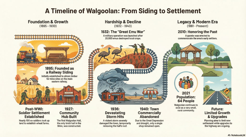
Demographics
Region: Wheatbelt
LGA: Westonia
Industry: Rail Siding, Soldier Settlement, Agriculture
Meaning of Name: Place where the short bushes grow
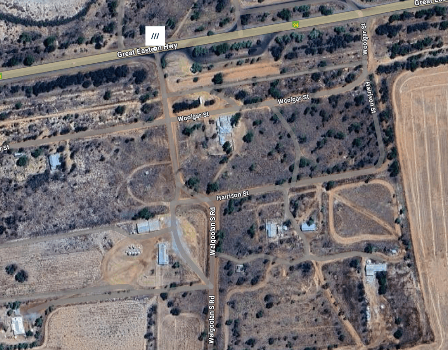
Open Street Map: -31.166339162238156, 118.54689500158075
What3Words: ///impose.catapulted.concentrate
Settled: 1895
Gazetted: 1923
Declined: 1940
Introduction
Walgoolan, in the Shire of Westonia, is a small population center, recording only 64 people in 2021. But local heritage records the origins of community buildings like the hall and tennis club back to the late 1920s and early 1930s. Walgoolan is historically notable for its role in the 1932 Great Emu War, an infamous military operation deployed to address the destruction of agricultural crops by migrating emus in the region. Furthermore, the location is a critical point for state infrastructure, with documentation detailing ongoing upgrades to the Great Eastern Highway to improve transport efficiency through the Wheatbelt area. However, the Shire of Westonia’s local planning strategy indicates that future development will be limited within the Walgoolan townsite, preferring to consolidate residential growth in the larger Westonia settlement.
History
Walgoolan is a small locality situated in the eastern Wheatbelt region of Western Australia, along the Great Eastern Highway, positioned between Merredin and Bodallin. The name Walgoolan is Aboriginal in origin, meaning place where the short bushes grow. The town’s history is inextricably linked to the Eastern Railway, the post-WWI Soldier Settlement scheme, and the infamous 1932 “Emu War”.
Establishment and Soldier Settlement
The settlement of Walgoolan began as a vital transport link rather than a township. It originated as a railway siding on the main eastern railway, established sometime between 1895 and 1899. Initially, this was a loop track used primarily for extracting timber destined for mining sites.
Land was set aside for the townsite in 1913, with lots surveyed in 1922, leading to the townsite being officially gazetted in 1923. The land was attractive to incoming residents because of its fertile soil, access to the goldfields water supply, and proximity to the Great Eastern Highway.
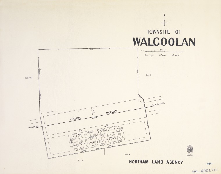
State Library of Western Australia1
The growth of Walgoolan was heavily driven by the Soldier Settlement scheme following World War I. The Australian government provided land to large numbers of discharged veterans, encouraging them to take up farming, often in agriculturally marginal areas. Nearly 100 settlers, most of whom were World War I veterans, took up land in the Walgoolan area for farming, primarily cultivating wheat.2 3
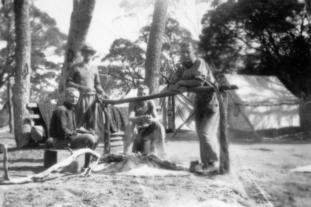
State Library of Western Australia4
During the 1920s and early 1930s, the community experienced significant growth and development. A total of five schools served the district, including the North Walgoolan School, which operated from 1925 to 1928, and the Walgoolan Siding School, established from 1930.5 6
Key infrastructure and social centers were established, including the Walgoolan Hall, constructed from 1927. This cement brick structure holds the distinction of being the only brick hall within the Shire of Westonia.7 It was a vital social and recreation facility, preventing isolation, and was used for church services, a baby clinic, a school, and CWA meetings. In 1953, the Hall was severely damaged by flooding causing the Westonia Road Board to ban its use until it had dried out and the damage could be assessed and repaired.8 Commercial activity was supported by a bank, originally the Bank of New South Wales in 1928, which became the Australian New Zealand Bank (ANZ) in 1932. Sporting life thrived, marked by the construction of the Walgoolan Tennis Club facility starting in 1929.9 In 1932, the Wheat Pool of Western Australia installed two grain elevators, each fitted with an engine, at the railway siding.
WA Now and Then10
The Great Emu War of 1932
The soldier-settlers faced extreme difficulties in the late 1920s and early 1930s. With the onset of the Great Depression in 1929, wheat prices plummeted, and government assistance promised to farmers failed to materialize. This challenging situation was aggravated by an ecological crisis when approximately 20,000 to 30,000 emus migrated to the area in late 1932.11
Emus found the newly cleared agricultural lands and additional water supplies in the marginal farming regions, including Walgoolan and nearby Campion, to be ideal habitats. The birds consumed and spoiled the wheat crops and caused significant damage to boundary fences, allowing rabbits to enter and cause further problems.
Farmers, many of whom were ex-soldiers, requested military assistance, leading to the deployment of the Royal Australian Artillery, armed with Lewis guns. This infamous event became known as the “Emu War”.
The military operation, commanded by Major Gwynydd Purves Wynne-Aubrey Meredith, officially began on November 2, 1932. The initial attempts to cull the birds were highly unsuccessful due to the emus’ speed and ability to scatter into small groups, frustrating the machine gunners. The media quickly seized upon the failure, leading to negative coverage, and the troops were withdrawn on November 8.
Following renewed support from farmers and the Premier of Western Australia, the military effort resumed on November 13, 1932. By the end of the operation on December 10, 1932, Major Meredith claimed 986 confirmed kills. Despite the challenges and international mockery, the use of machine guns was later reported to have been effective in saving what remained of the wheat.
The Emu War brought international attention to the plight of the Walgoolan community. Although military aid was denied in subsequent requests (1934, 1943, and 1948), the government favored a bounty system, which proved successful (57,034 bounties claimed in 1934), and the widespread adoption of exclusion barrier fencing became common practice to protect crops from emus and other vermin.12
Decline of the Townsite
The decline of Walgoolan and the associated soldier settlement was caused not by emus, but by persistent economic and environmental hardship. The Great Depression and a succession of droughts took a severe toll on the area, prompting farmers to abandon their holdings.13
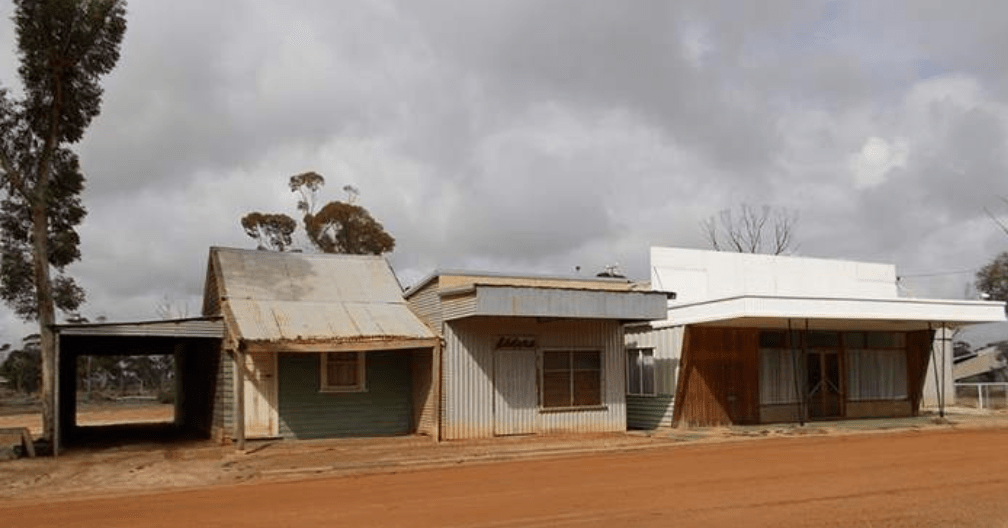
The commercial viability of the town dwindled rapidly; by 1940, only a single shop remained open, and once it closed, the townsite was considered abandoned as a commercial center. The community persisted socially for a time, evidenced by the CWA Ladies building a brick supper room extension to the Hall in 1961.14 However, the consolidation of smaller farms into larger corporate holdings over time continued to diminish the population. The Walgoolan Hall, though still standing, has seen reduced use as the local population has diminished.
Walgoolan Today and Future Outlook
Walgoolan remains a gazetted townsite in the Shire of Westonia. It is located on the Great Eastern Highway. Census data shows fluctuations in the small population: in the 2016 Census, there were 52 people recorded, increasing to 64 people in the 2021 Census. Walgoolan covers approximately 40.4 hectares, comprising 51 residential sized lots and seven rural residential lots, with six lots developed.15
Today, Walgoolan appears largely derelict, though active farms remain nearby. Remaining notable features include the abandoned town hall and the ruins of the tennis club. The community’s history is commemorated by a rest stop featuring a gazebo that was erected in 2010 to honor early settlers and pioneers.
The Shire of Westonia’s Local Planning Strategy16 acknowledges Walgoolan but indicates a firm strategy to limit further settlement in the townsite. The focus of the Shire’s growth and resource allocation is directed toward the main Westonia townsite. However, infrastructure improvements continue in the area, including upgrades to the Great Eastern Highway between Walgoolan and Southern Cross, such as a bridge replacement and a 3 km road realignment near Walgoolan.
Timeline
- 1895–1899: Walgoolan established as a railway siding on the main eastern railway, initially used to obtain timber for mine sites.
- 1913: Land was set aside for the Walgoolan townsite.
- Post-WWI (early 1920s): Establishment of the soldier settlement; nearly 100 ex-soldiers took up land for farming, primarily wheat.
- 1923: Walgoolan townsite was officially gazetted.
- 1925–1928: North Walgoolan School operated.
- 1927: The first Walgoolan Hall (a cement brick structure and the only brick hall in the Shire) was established with help from the CWA.
- 1928: A bank, initially the Bank of New South Wales, began operations.
- 1929: The Great Depression began. Construction of the Walgoolan Tennis Club started.
- 1930: The Walgoolan Siding School was established.
- 1932 (July 6): The Wheat Pool of Western Australia announced the installation of two grain elevators at the railway siding.
- 1932 (Late): Approximately 20,000 to 30,000 emus migrated to the area, causing massive crop and fence destruction.
- 1932 (Nov 2 – Dec 10): The military operation known as the Emu War occurred in the district following requests from soldier-settlers.
- 1932: The Bank of New South Wales became the Australian New Zealand Bank (ANZ).
- 1934: A state school was constructed. Farmers first requested military aid renewal (rejected). The bounty system was highly effective in the region (57,034 bounties claimed over six months).
- 1936: A violent storm severely damaged the town, temporarily removing the roof of the town hall.
- 1940: Only a single shop remained open; the townsite was effectively abandoned commercially soon after due to the Great Depression and drought.
- 1961: The brick supper room extension was added to the Walgoolan Hall by the CWA Ladies.
- 1966: Bridge 0629, a prestressed concrete road bridge, was constructed on the Great Eastern Highway.
- 2010: A gazebo was erected to commemorate early settlers and launch the local history book East of the Fence.
- 2021: The population of Walgoolan was recorded as 64 people.
- Ongoing: Upgrades to the Great Eastern Highway between Walgoolan and Southern Cross are underway, including bridge replacement and realignment near Walgoolan.
- Future Planning: The Shire of Westonia’s Local Planning Strategy aims to limit further settlement in the Walgoolan townsite
Map
Sources
- State Library of Western Australia, n.d. Townsite of Walgoolan. Retrieved 2 Dec 2025 from https://encore.slwa.wa.gov.au/iii/encore/record/C__Rb1982797 ↩︎
- Wikipedia, 2025. Walgoolan, Western Australia. Retrieved 2 Dec 2025 from https://en.wikipedia.org/wiki/Walgoolan,_Western_Australia ↩︎
- Wikipedia, 2025. Emu War. Retrieved 2 Dec 2025 from https://en.wikipedia.org/wiki/Emu_War ↩︎
- State Library of Western Australia, n.d. Day Collection of Photographs: BA975/1-5. Retrieved 2 Dec 2025 from https://encore.slwa.wa.gov.au/iii/encore/search/C__SDay%20collection%20of%20photographs%20SMCLN__Orightresult?lang=eng&suite=def ↩︎
- Heritage Council of WA, 2017. North Walgoolan School Site. Retrieved 2 Dec 2025 from https://inherit.dplh.wa.gov.au/Public/Inventory/Details/61eb1e97-d09c-49fc-9bd5-252b03956126 ↩︎
- Heritage Council of WA, 2017. Walgoolan Siding School Site. Retrieved 2 Dec 2025 from https://inherit.dplh.wa.gov.au/Public/Inventory/Details/416199ff-bd70-4c4f-9ac5-4ac5db50853d ↩︎
- Heritage Council of WA, 2017. Walgoolan Hall. Retrieved 2 Dec 2025 from https://inherit.dplh.wa.gov.au/Public/Inventory/Details/b5320ee0-e2c2-448d-926b-004e7ffaa7e5 ↩︎
- Walgoolan Ramblings. (1953, May 21). Merredin Mercury and Central Districts Index (WA : 1912 – 1954), p. 7. Retrieved December 2, 2025, from http://nla.gov.au/nla.news-article252707426 ↩︎
- Heritage Council of WA, 2017. Walgoolan Tennis Club. Retrieved 2 Dec 2025 from https://inherit.dplh.wa.gov.au/Public/Inventory/Details/8fe58c0e-165c-4e26-90ee-0e51a040387b ↩︎
- WA Now and Then, n.d. Walgoolan. Retrieved 2 Dec 2025 from https://www.wanowandthen.com/ghost-towns24.html ↩︎
- Brendan’s Odyssey. Walgoolan and the Great Emu War of 1932. Retrieved 2 Dec 2025 from https://youtu.be/JxxpdT27aJ4?si=gySNtDRJM4ChN-hn ↩︎
- Wikipedia, Emu War: refers to the end of the war and its aftermath ↩︎
- Wikipedia, Walgoolan: refers to the impact of the Great Depression ↩︎
- Heritage Council, Walgoolan Hall: refers to the use of the hall by CWA ↩︎
- Australian Bureau of Statistics, 2021. 2021 Census All Persons QuickStats : Walgoolan. Retrieved on 2 Dec 2025 from https://www.abs.gov.au/census/find-census-data/quickstats/2021/SAL51504 ↩︎
- Shire of Westonia, 2023. Draft Local Planning Strategy. Retrieved 2 Dec 2025 from https://www.westonia.wa.gov.au/Profiles/westonia/Assets/ClientData/2023_Westonia_Local_Planning_Strategy_Final.pdf ↩︎
