First of all, an apology. Due to a number of circumstances, we did not publish our statistical report as at 30 Sep 2025. So this report covers our progress for the two months since 31 August 2025.
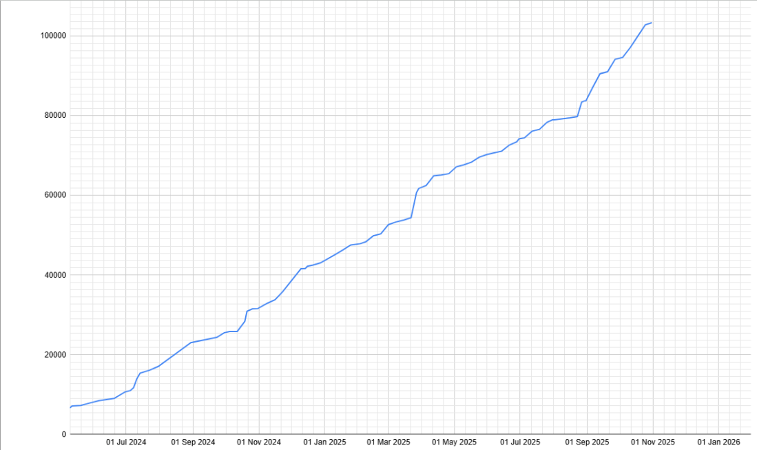
As previously announced during the month of October, we reach the major milestone of 100,000 records captured by our team. Congratulations to all project team members for a magnificent effort.
The total records captured up to 31 October 2025 is 103,384. During the past two months, about 30 communities have been added to the list of those communities who have any records captured. These new communities are highlighted in the list below.
As at 31 Oct 2025, our Master List shows we have identified 617 ghost towns, plus 833 alternative names relating to 396 of the 617 towns. Our task means that we research and record people associated with all 1,450 of those town names.
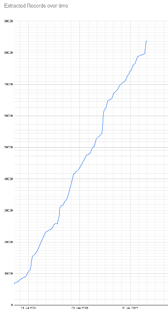
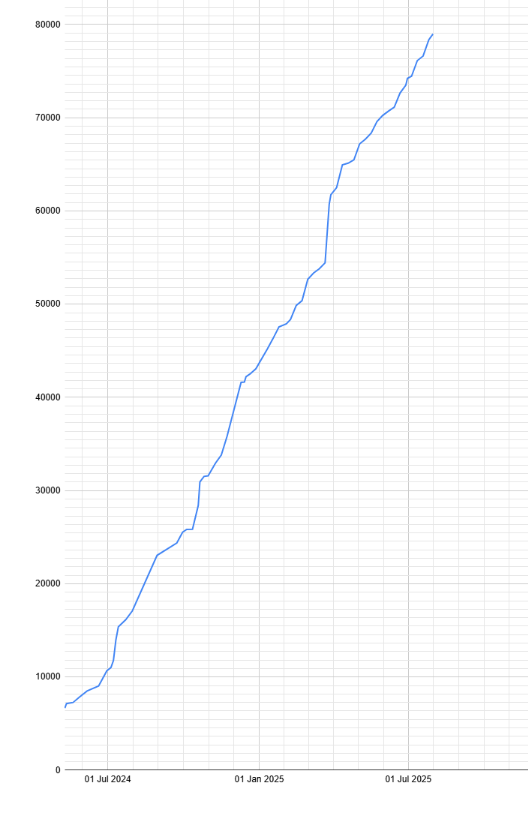
Our project team are working hard to capture as many records as possible of the people in WA’s ghost communities. Once our website and search engine is fully operational you will be able to access some of these records. Here are the latest figures followed by a simple line graph showing the growth in total numbers:
List of Communities
Quick Tip: to quickly see if your favourite ghost town is already in this list, press CTRL+f [find].
| Community name (including alternative names for some communities) | Records Captured |
|---|---|
| 25 Mile | 4 |
| 36 Mile Police Station | 52 |
| 4 Mile (Menzies) | 2 |
| 45 Mile | 3 |
| 90 Mile | 319 |
| Abbott’s | 58 |
| Agnew | 4 |
| Aldersyde | 4 |
| Aldinga | 52 |
| Anaconda | 2 |
| Argyle | 1 |
| Argyle Police Station | 6 |
| Arrino | 2 |
| Baandee | 120 |
| Bamboo Creek | 34 |
| Bandee1 | 76 |
| Bardoc | 47 |
| Barton | 88 |
| Benjaberring | 13 |
| Beria | 1 |
| Bernier Island | 2 |
| Big Bell | 6527 |
| Black Flag | 43 |
| Black Range | 14 |
| Bonnie Vale | 178 |
| Boogardie | 1 |
| Boorabbin | 4 |
| Bootenal | 199 |
| Boyadine | 83 |
| Boyerine | 309 |
| Broad Arrow | 57 |
| Brown Hill | 173 |
| Brown’s Mill | 14 |
| Buchanan River | 5 |
| Buldania | 18 |
| Bullabulling | 26 |
| Bullfinch | 66 |
| Bulong | 798 |
| Bummers Creek | 15 |
| Bungarun Lazarette2 | 60 |
| Bunjil | 14 |
| Buntine | 122 |
| Burakin | 8 |
| Burbanks | 2 |
| Burbidge | 3 |
| Burnakura | 57 |
| Burtville | 41 |
| Butcher’s Inlet | 16 |
| Butterfly | 1 |
| Camden Harbour | 14 |
| Camden Harbour Expedition | 8 |
| Cane Grass Swamp Hotel | 11 |
| Canegrass | 102 |
| Carbine | 438 |
| Carinyah | 36 |
| Caron | 11 |
| Cashmans Bore | 1 |
| Celebration City | 1 |
| Chesterfield | 1 |
| Comet Vale | 70 |
| Condon | 2 |
| Coodardy | 6 |
| Coonana | 38 |
| Cork Tree Flat | 3 |
| Corunna Downs Station | 17 |
| Cossack | 38703 |
| Craiggiemore | 9 |
| Cuddingwarra | 14 |
| Cue | 6002 |
| Culham | 178 |
| Darlot | 2 |
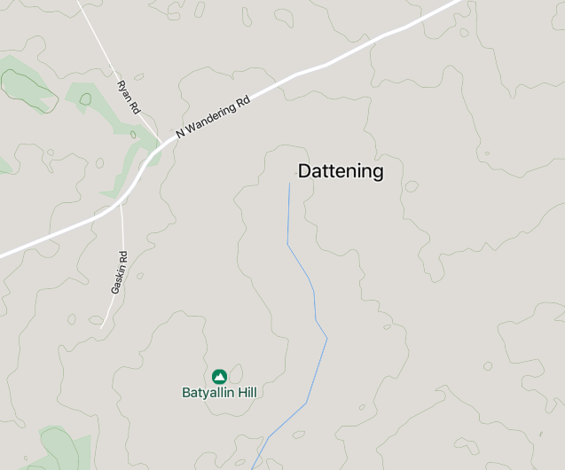
| Dattening | 3 |
| David Copperfield Mine | 13 |
| Davyhurst | 25 |
| Day Dawn | 3457 |
| Delambre Island | 2 |
| Derdebin | 4 |
| Dinningup | 1 |
| Dinninup | 1533 |
| Diorite King | 8 |
| Dore Island | 2 |
| Dowerin Lakes | 405 |
| Dudawa | 15 |
| Duketon | 12 |
| Dundas | 1 |
| Dunnsville | 1 |
| East Kirup | 51 |
| East Kirup Timber Mill | 8 |
| East Kirupp | 8 |
| Edjudina | 40 |
| Ejanding | 9 |
| Elverdton | 2 |
| Eradu | 650 |
| Erlistoun | 27 |
| Eticup | 7 |
| Eucalyptus | 152 |
| Eucla | 159 |
| Euro | 30 |
| Ferguson Mill3 | 104 |
| Ferguson Timber Mill (Lowden) | 1 |
| Ferguson Timber Mill (Yarloop) | 2 |
| Feysville | 293 |
| Field’s Find | 200 |
| Fields Find | 650 |
| Fly Flat | 5 |
| Gabanintha | 876 |
| Galena | 181 |
| Galena Bridge | 3 |
| Gap Well | 3 |
| Garden Gully | 9 |
| Garden Well | 2 |
| Geraldine | 141 |
| Geraldine Mine | 293 |
| Ghooli | 343 |
| Golden Valley | 14 |
| Goodwood | 29 |
| Goodwood Timber Mill (Donnybrook) | 888 |
| Goomarin | 1373 |
| Goongarrie | 6409 |
| Gordon | 5 |
| Grants Patch | 1 |
| Grass Patch | 15 |
| Greenough River | 492 |
| Gum Creek | 8 |
| Gwalia | 4685 |
| Hampton Plains | 7 |
| Hawk’s Nest | 38 |
| Hawkes Nest Gold Mine | 4 |
| Hawks Nest (Laverton) | 9 |
| Hearson Cove | 1 |
| Higginsville | 689 |
| Holden’s Find | 2 |
| Holyoake | 10 |
| Howatharra | 2 |
| Ida H | 1 |
| Ives Find | 1 |
| Jarman Island | 34 |
| Jibberding | 155 |
| Jitarning | 33 |
| Jonesville | 1 |
| Kallaroo | 64 |
| Kamballie | 130 |
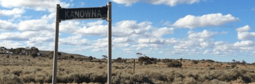
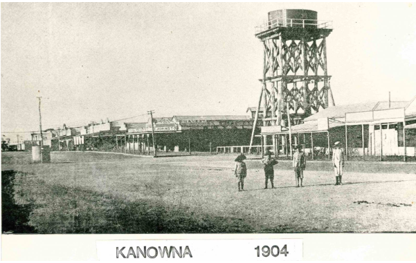
| Kanowna | 7606 |
| Kathleen | 8 |
| Kathleen Valley | 29 |
| Kintore | 16 |
| Kodj Kodjin | 46 |
| Kokeby | 2 |
| Kookynie | 171 |
| Korrelocking | 16 |
| Kudardup | 27 |
| Kulja | 24 |
| Kunanalling | 166 |
| Kurnalpi | 60 |
| Kurrajong | 8 |
| Kwelkan | 11 |
| Lake Austin | 117 |
| Lake Darlot | 15 |
| Lancefield | 8 |
| Lawlers | 18 |
| Linden | 2 |
| Londonderry | 58 |
| Ludlow (Capel / Busselton) | 460 |
| Ludlow Bridge | 1 |
| Malcolm | 749 |
| Mallina | 10 |
| Mangowine | 33 |
| Marchagee | 8 |
| Mark’s Siding | 10 |
| Marrinup | 4 |
| Maya | 35 |
| Merilup | 12 |
| Mertondale | 5 |
| Mia Moon | 68 |
| Minnivale | 219 |
| Mogumber | 875 |
| Mollerin | 3 |
| Mount Ida | 2 |
| Mount Jackson | 16 |
| Mount Kokeby | 140 |
| Mount Malcolm | 325 |
| Mount Margaret | 25 |
| Mount Monger | 5 |
| Mount Morgans | 33 |
| Mt Ida | 1 |
| Mulga Queen Community | 190 |
| Mulgabbie | 5 |
| Mulgarrie | 2 |
| Mulline | 1 |
| Mulwarrie | 2 |
| Mundaring Weir | 277 |
| Murrin Murrin | 531 |
| Nalkain | 815 |
| Nalkain Railway Siding | 12 |
| Nannine | 281 |
| Naretha Railway Siding | 9 |
| Needilup | 2 |
| Neta Vale Telegraph Station | 16 |
| New England | 1 |
| Niagara | 294 |
| Niagara (North) | 5 |
| Ninety Mile | 139 |
| Ninghan Station | 15 |
| Nippering | 6 |
| No 6 Pump Station (Ghouli) | 44 |
| Nomans Lake | 17 |
| North Bandee4 | 40 |
| Nugadong | 766 |
| Nullagine | 17 |
| Nungarin (North) | 27 |
| Nyamup | 5 |
| Old Dowerin | 143 |
| Old Halls Creek | 3782 |
| Ora Banda | 162 |
| Paddington | 7 |
| Payne’s Find | 103 |
| Paynesville | 9 |
| Peak Hill | 17 |
| Piesseville | 35 |
| Pilbarra | 30 |
| Pindalup Ports No.1 Timber Mill (Dwellingup) | 20 |
| Pindalup Railway Siding | 20 |
| Pingarning | 97 |
| Pingin | 3 |
| Pinjin | 25 |
| Pinyalling | 1 |
| Plavins | 15 |
| Port George IV | 1 |
| Quindalup Timber Mills | 3 |
| Red Lake School | 8 |
| Redcastle | 12 |
| Reedy | 14 |
| Roaring Gimlet | 149 |
| Rothesay | 42 |
| Rothsay | 63 |
| Sandstone | 20 |
| Shannon | 19 |
| Shay Gap | 1 |
| Sherlock | 3 |
| Siberia | 12 |
| Sir Samuel | 1 |
| Smithfield | 6 |
| Spargoville | 1 |
| Speakman’s Find | 1 |
| Stake Well | 2 |
| Star Of The East | 22 |
| Stratherne | 13 |
| Sunday Island Misson Station | 44 |
| Surprise | 71 |
| Surprise South | 5 |
| Tampa | 9 |
| Tardun | 1 |
| Taylor’s Well | 316 |
| Taylors Well | 22 |
| Tenindewa | 8 |
| Tien Tsin | 62 |
| Trafalgar | 346 |
| Tuckanarra | 17 |
| Two Boys | 13 |
| Ularring | 189 |
| Ullaring | 24 |
| Vosperton | 1 |
| Walgoolan | 18 |
| Warriedar | 16 |
| Webb’s Patch | 1 |
| Whim Creek | 2 |
| White Feather | 24 |
| White Hope | 1 |
| White Well | 9 |
| Wittenoom | 1 |
| Woodley’s Find | 4 |
| Woolgangie | 3 |
| Woolgar | 318 |
| Woop Woop Timber Mill | 305 |
| Wyening | 30 |
| Wyola | 734 |
| Xantippe | 12 |
| Yandanooka | 135 |
| Yankee Town | 4 |
| Yarri | 1 |
| Yerilla | 49 |
| Yetna | 58 |
| Yornup | 73 |
| Youanmi | 17 |
| Youndegin | 5 |
| Yuba | 21 |
| Yundamindera | 1 |
| Yunndaga | 324 |
| Zanthus | 20 |
- Recorded as Bandee in error. This will be corrected to Baandee in the future. ↩︎
- More recent research requires a re-examination of these records. They will be updated once the differentiation between the Lazarettes at Cossack and Derby is fully understood. ↩︎
- These records relate to Ferguson Mill school/s. Unable to determine which location. ↩︎
- Recorded as North Bandee in error. This will be corrected to North Baandee in the future. ↩︎
Progress Graph