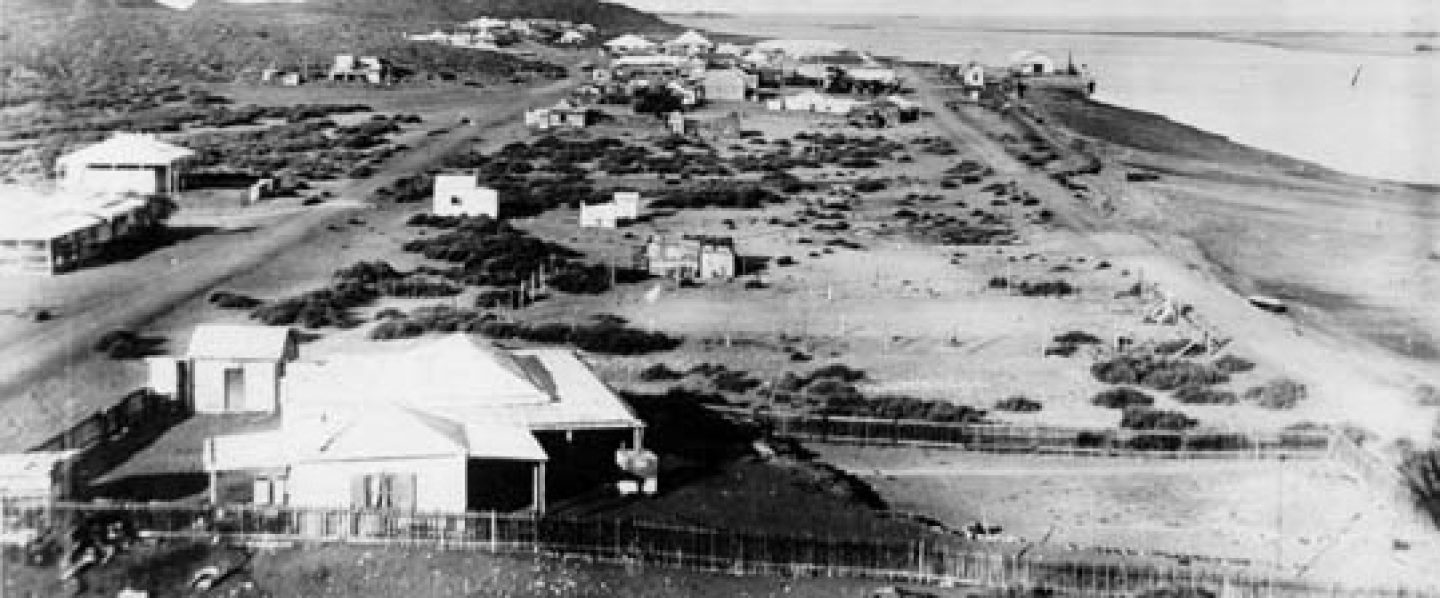
Hubert Burton was having a bad day. The Roebourne Police Court, sitting on 31st Oct 1888, heard four charges arising from offences against a James Edkins all in the course of one day at Yule River. Two charges were for assaulting Edkins. The third charge was for using abusive and threatening language about Edkins. And then to top it all off, there was a fourth charge for false imprisonment – Burton was alleged to have taken Edkins into custody and detained him for a period of three hours.
Burton was found guilty on all four counts. He was fined 20/- or one month’s imprisonment on each charge and ordered to pay £6 1s in court costs.
But what made him do it? Well, here is the twist in the tale…
Having dealt with Burton, the court turned its attention to Edkins. Mr Roderick McKay charged Edkins with assaulting an aboriginal called Jerry, at Yule River, on the same day that the Burton assaults took place. He was found guilty and fined £5 or 2 months imprisonment.
While it would seem that the magistrate was pretty clear about who was the villain of the piece, I leave it to you to draw your own conclusions.
Author’s note: The report of the hearings was found in the Western Mail – ROEBOURNE POLICE COURT. (1888, December 1). Western Mail (Perth, WA : 1885 – 1954), p. 7. Retrieved October 25, 2025, from http://nla.gov.au/nla.news-article32714243
Author’s Note: This report is taken from The West Australian – 15 Aug 19411.
Farthest-east School.
“The State Government is about to provide a school for 20 children at Coonana, 100 miles east of Kalgoorlie on the trans-Australian railway. It will be the Education Department’s farthest-east school. The Commonwealth Government is building cottages for its railway employees at Coonana, where there are about 12 married men with families, and the department took advantage of the presence of builders to have the school erected at the same time. It will consist of a wooden classroom (20 ft. square), for the construction of which the tender of Henry Martin and Co., amounting to £627, has been accepted.”
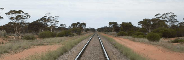
The Coonana Primary School operated from 1942 until 19802. Coonana Siding was named after a nearby hill that was first recorded as Coonaanna by W.P. Goddard in 1890. The possible meaning of the word is “hill of ashes”3.
In the early days of January 1907, the quiet mining town of Higginsville, Western Australia, found itself at the centre of a curious legal drama. Nestled in the Goldfields-Esperance region, Higginsville had only recently been gazetted as a townsite that same year. Named after prospector Patrick Justice Higgins, the settlement was a modest but active hub for goldfield workers, with a population that hovered around a few dozen. Life in Higginsville revolved around the rhythms of mining, the railway, and the local hotel—often the social heart of such frontier towns.
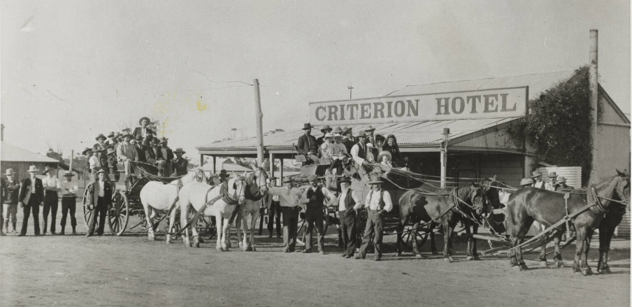
Criterion Hotel, Higginsville 1908 Photograph in the collection of the State Library of Western Australia1
It was at this hotel that the alleged crime took place. On the night of January 3rd, Charles Jacobson, a carpenter and long-time resident of the goldfields, was accused of breaking and entering the licensed premises of Hannah Warburton with intent to commit a crime. The trial commenced the following afternoon before the Chief Justice and a jury of twelve, with Crown Solicitor A. E. Barker prosecuting and Mr. F. H. Rickarby defending the accused.
According to the prosecution, Jacobson had been among the last patrons in the hotel bar before closing. Later that night, a disturbance was heard by one of Warburton’s sons, who, along with another man, discovered that entry had been forced through the beer cellar. Jacobson was found inside, barefoot, with his boots left outside the flap—an odd detail that would become central to the case.
The Crown argued that the cellar flap had been opened with force, suggesting intent. Jacobson’s proximity—his camp lay just 50 yards away—added to the suspicion. Though he claimed to have fallen into the cellar and struck his head, the prosecution questioned his motives. “If he only wanted to steal a drink,” Barker noted, “it was a crime.”
Testimonies from Hannah Warburton and her family, as well as Harry King and Constable Finch, supported the prosecution’s narrative. Jacobson, however, maintained that he had no recollection of entering the cellar, attributing his condition to drunkenness and fatigue. He insisted he had returned home to his two young sons after the incident.
The defence leaned heavily on the testimony of Jacobson’s children. Carl Jacobson, aged 11, recounted seeing his father leave the camp after being invited for a drink by an unknown man. He described watching his father from a hole in the tent wall and later witnessing him return, bruised and disoriented. His twin brother, Thomas, corroborated the account.
Mr. Rickarby, in his address to the jury, emphasized the lack of clear intent and the possibility of an accident. Mr. Barker, confident in the simplicity of the case, chose not to offer a rebuttal.
The court adjourned at 4:15 p.m. on 22 March 1907, with the Chief Justice set to deliver his summation the following morning. When proceedings resumed, the jury returned a verdict of acquittal. Jacobson’s story—that he had accidentally fallen into the cellar and had no knowledge of any attempted robbery—was ultimately believed. The case closed not with condemnation, but with a reminder of how easily circumstance can be mistaken for intent.
Author’s Note
This article was prepared from contemporary accounts found in newspapers from Kalgoorlie 2, Adelaide 3 and Sydney.4
Every town or district has its quirks, and often the name carries a story of its own. In the case of Dattening—sometimes mistakenly called Taylor’s Well—the history lingers in the words people still use. Here’s how that tangle came to be, shared by a correspondent of the time: 1
Most readers are wondering where “Dattening” is, writes a correspondent. Well it is erroneously known as “Taylor’s Well.”
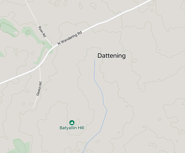
There’s such a tangle here that a word of explanation would not be out of place. Look on the map 2; the place is named “Dattening,” and Dattening is the real name.
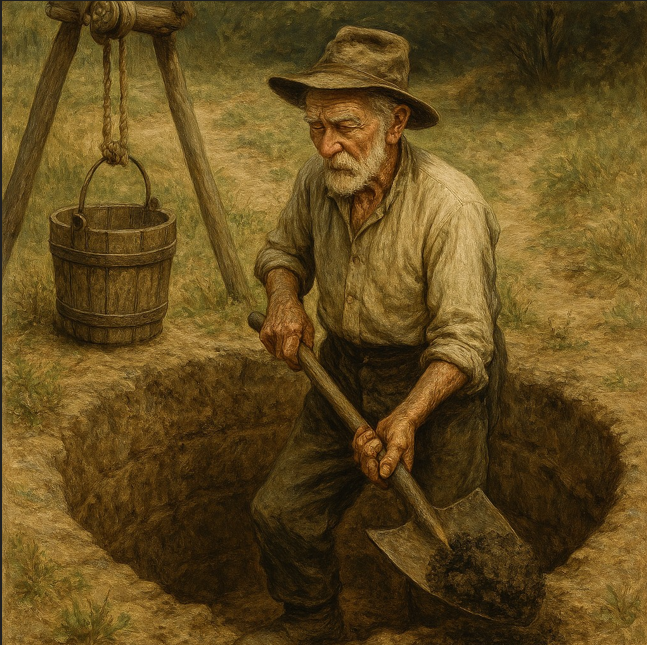
How it came to be called “Taylor’s Well” is thus. Years ago, old Norry Taylor dug a well there for use when travelling stock, and it was a real tip top supply of fresh water, and in those days, before much clearing was done, water was not too plentiful so the early pioneers used to cart their supply of “Adam’s Ale” from the well, and as they went to “Ole Norry Taylor’s Well” to get it, gradually became known as Taylor’s Well.
However, the post office and the telephone exchange are known as “Dattening,” it behoves you to get used to calling it “Dattening.”
Dattening, Western Australia [cartographic material] / prepared under the direction of the Surveyor General, Department of Lands and Surveys, Western Australia. Retrieved August 27, 2025, from https://catalogue.nla.gov.au/catalog/5786516↩︎
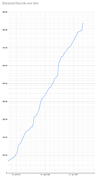
The total records captured up to 31 July 2025 is 83,781. During the past month, the communities of Argyle (and Argyle Police Station), Boogardie, Craiggiemore, Derdebin, Howatharra, Kwelkan, Lancefield, Merilup, Noman’s Lake, Shay Gap, Stratherne, Sunday Island Mission, Tardun, Trafalgar, Ullaring, White Well, Wittenoom and Yarri have found their way into our captured list.
Our project team are working hard to capture as many records as possible of the people in WA’s ghost communities. Once our website and search engine is fully operational you will be able to access some of these records. Here are the latest figures followed by a simple line graph showing the growth in total numbers:
Quick Tip: to quickly see if your favourite ghost town is already in this list, press CTRL+f [find].
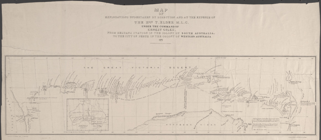
Map of Giles’s Route (Surveyor General’s Office, 1875) – Reproduced courtesy of the National Library of Australia. Digitized and available via the National Library of Australia; this work is out of copyright and free to use for public purposes.
Among the explorers who expanded knowledge of the Australian interior in the nineteenth century, Ernest Giles occupies a distinguished place. His 1875 expedition, financed through the generosity of the South Australian pastoralist and politician Thomas Elder, represented a major advance in geographical discovery, demonstrating both the challenges of crossing the continent’s deserts and the determination required to overcome them.
At the time, vast tracts of inland Australia remained uncharted, and speculation abounded about the potential of the interior for settlement and communication. Earlier surveys by Baron Ferdinand von Mueller and Augustus Gregory in the 1850s had suggested the broad character of these lands, but much remained unknown. Elder, convinced of Giles’s skill as a leader and of the value of camels for desert travel, offered to fund a new expedition to establish as direct a route as possible between South Australia and Western Australia.
The expedition commenced from Port Augusta in May 1875, and the true crossing began on 27 July from Youldeh. Giles’s party included nineteen camels, provisions for eight months, and equipment for carrying water, all vital in a region where survival could never be taken for granted. From the outset, the expedition encountered formidable obstacles. Sandhills, spinifex, and dense mallee scrub made progress slow, while the scarcity of permanent water dictated the pace and direction of travel.
In an early attempt to cover more ground, Giles divided his men: he himself explored westward while William Tietkens and Young struck north in search of the Musgrave Ranges. Both ventures revealed the inhospitality of the land. Giles discovered saline springs and barren scrub, with no signs of animal or human life. His companions fared little better, returning without sighting the Musgraves or finding fresh water.
At one point disaster nearly struck when the camels bolted. The animals were eventually recovered after a long chase, but had they been lost the expedition would have faced almost certain failure. The precariousness of the journey was underlined again in September, when the party endured seventeen days and 325 miles without locating water. Exhaustion and despair led some members to propose slaughtering camels for survival. Giles, however, refused to abandon hope, and perseverance was rewarded when the party discovered a hidden lake. This crucial water source, named Queen Victoria’s Spring, ensured their survival and allowed them to continue.
From this point the nature of the country began to change. Granite outcrops and quartz appeared, bringing with them more reliable supplies of water and pasture. Yet dangers remained. At Ularring, Giles and his men encountered a large and well-organised Aboriginal group who mounted a determined attack. The explorers’ firm defence forced the assailants to withdraw, and the incident remained Giles’s most serious conflict with Indigenous Australians.
Approaching Mount Churchman, Giles noted that the surrounding terrain did not match Augustus Gregory’s earlier chart, which had described the area as flat. Instead, Giles observed ranges of iron-rich and volcanic-looking rock, so magnetic that compass readings proved unreliable. These discrepancies highlighted both the difficulties of accurate surveying and the continuing importance of first-hand exploration.
On 4 November 1875, after a journey of some 2,500 miles, Giles and his party finally reached settled country at Tootra, a sheep station owned by the Clunes brothers in Western Australia. Their safe arrival was greeted with warm public acclaim. Although the expedition had not revealed fertile lands ready for immediate settlement, it had achieved much in both scientific and practical terms. A direct east–west route had been established, new water sources had been identified, and the suitability of camels for such arduous work had been conclusively demonstrated.
The 1875 expedition stands as a testament to Giles’s qualities as an explorer. His leadership, endurance, and refusal to succumb to despair carried his party through regions he described as “utterly devoid of animal life” and “utterly forgotten by God.” While the lands traversed were not destined for agricultural development, the knowledge gained contributed to the broader project of mapping and understanding the Australian interior.
In this respect, Ernest Giles belongs to the company of Gregory, Stuart, and Eyre—men whose journeys across the deserts and ranges expanded the limits of colonial knowledge and shaped the geographical imagination of nineteenth-century Australia. His 1875 crossing of the continent remains one of the most remarkable achievements of its era, demonstrating the extraordinary perseverance required to chart a land as unforgiving as it is vast.
AUTHORS NOTE: This article is based on an 1876 correspondent’s account of Giles’s expedition.1 More recent accounts of the Giles expedition have questioned the contemporary accounts of the Ularring incident.
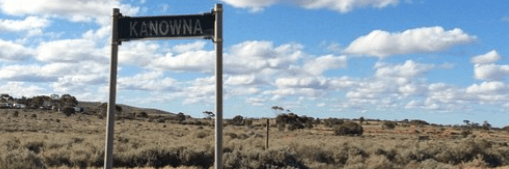
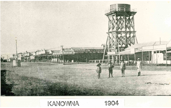
On Friday 29 August, 2025, we will move into Phase 4 of our project and that adds 16 new communities to the list of communities on which we are already working. The biggest community in this phase is Kanowna. If you have any information about these communities, or any of the communities on our master list, please contact us.
Image from our project partner Eastern Goldfields Historical Society
The new 16 in alphabetical order
4 Mile (Leonora)
Bootenal (aka Boolungu, Bootanoo, Bootanu and the Bootenal Railway Siding)
Buldania
Coonara (aka the Coonara Railway Siding)
Gabanintha
Gums (aka The Gums)
Hawks Nest (aka Hawk’s Nest, Hawkes Nest and the Hawkes Nest Gold Mine)
Jibberding
Jitarning (aka Geetaring)
Kanowna (aka White Feather and Cement Workings)
Kodj Kodjin (aka North Baandee)
Londonderry (aka Golden Hole Mine)
Pilbarra (aka Pilbarra Creek, Pilbarra Pool, Yandeyarra Hotel and Yule River, but NOT Pilbara)
Pingarning
Plavins (aka Plavins Timber Mill and Plavins Railway Siding)
Woolgar (aka Yundaga, Yundagga, Yunndaga and Yunndega)
Previous phases have covered the following communities:
I have noticed something today while researching the ghost community of Woop Woop. The name “Woop Woop” has often been used as a humorous or derogatory adjective.
If you have been following along with our project, you will already know that Woop Woop is one of the communities included in Phase 2. Woop Woop was a timber mill situated about 70Km south of Collie, and just a couple of Kms from the little town of Wilga, in the Shire of Boyup Brook. It only last for three years (1925-1928) but in that time it had six huts for single men, two houses, a boarding house, an office, and the Mill itself.
So today I have been working through a publication call The Guardian that has been published in Perth since 1937. While doing this I came across these “references” to Woop Woop – not to the place, but in a completely different context.
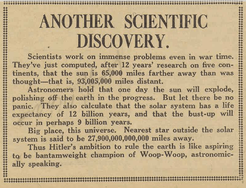
On 27 November, 1942, a random report about a scientific discovery related to the size of the solar system (and the universe) was concluded with a pretty obscure reference to Adolf Hitler as the bantamweight champion of Woop-Woop. 1
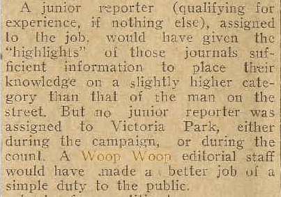
In February 1945, in a report decrying poor quality journalism in relation to reports on the distribution of preferences in Victoria Park. Claiming that any junior reporter would have done a better job than the senior reporters tasked with informing the public. The report concludes with the statement “A Woop Woop editorial staff would have made a better job of a simple duty to the public”. 2
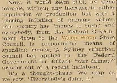
Elections once again figure in a report from January 1947, where everyone from the Federal Government all the way down to “the Woop Woop Shire Council” is looking for a handout. 3
These stories may have been meant to be humorous, but between 1937 and 1954, seven times the name “Woop Woop” was used in a way that, if I had been a local resident, would have seen me writing a letter to the editor to demand an apology. And, perhaps, in this litigious age, seeking compensation.
A LAST NOTE: The seven articles are all in The Guardian. There are probably hundreds in the 365 other Western Australian newspapers currently digitised on Trove. Have a look for yourself and see what you can find.
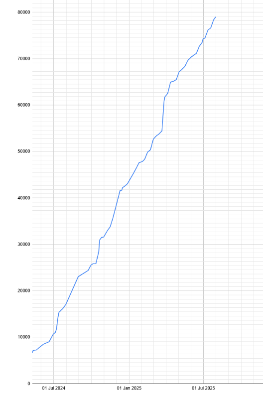
The total records captured up to 31 July 2025 is 78,987. During the past month, the communities of Black Range, Burbridge, Cork Tree Flat, Culham, Dattening, Garden Gully, Gum Creek, Hawk’s Nest, Kintore, Kudardup, Linden, Paynesville, Red Lake School, Spargoville, Warriedar, Wyening, and Zanthus have found their way into our captured list.
Our project team are working hard to capture as many records as possible of the people in WA’s ghost communities. Once our website and search engine is fully operational you will be able to access some of these records. Here are the latest figures followed by a simple line graph showing the growth in total numbers:
Quick Tip: to quickly see if your favourite ghost town is already in this list, press CTRL+f [find].
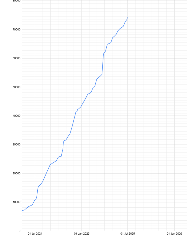
The total records captured up to 30 June 2025 is 74,222. During the past month, the communities of Barton, Bummers Creek, Cuddingwarra, Davyhurst, East Kirup Timber Mill, Fly Flat, Galena Bridge, Kathleen, Kathleen Valley, Mount Ida, Mulgabbie, Naretha Railway Siding, Niagara North, Pingin, Pinjin, Sandstone, Sir Samuel, Surprise South, Webb’s Patch, and Yundamindera have found their way into our captured list.
Our project team are working hard to capture as many records as possible of the people in WA’s ghost communities. Once our website and search engine is fully operational you will be able to access some of these records. But for now, here are the latest figures along with a graph showing the growth in total numbers:
Quick Tip: to quickly see if your favourite ghost town is already in this list, press CTRL+f [find].