When we started this project we had a list of about 250 Ghost Towns. It didn’t take very long before the list began to grow. As at today’s update, we have 628 (with a couple that we are holding in reserve pending confirmation of their ghostly status).
All three lists have been updated (alphabetical listing, by Region, by LGA) and the changes have been marked in the Alpha and LGA lists. There have been lots added with this update, so check it out! If you want to see what is new in your area, I suggest checking the LGA list out first, as this will tell you how many communities have been identified around you, and particularly will highlight where new entries have been added. Just remember when looking at the number of communities this includes a line entry for any known alternative names of a particular community, so that could mean that the same community is listed twice, three times or even more depending upon how many times it has changed its name over time.
A lot of new towns came to light following the broadcasts on ABC Radio and we are really grateful to everyone for their interest, enthusiasm and participation. But every day we are getting new leads, so keep checking back to see the updates and subscribe to this blog to be notified when there’s a new post.
If you want to add a ghost town or abandoned community to the list, please contact us.
As I have been researching ghost towns, I have often come across the phrase “state battery”. Without actually taking the time out to discover what this was, ideas that flittered through my mind included some sort of power generation facility or a method of providing fresh eggs and chickens in the outback.
Today is the day. I have found out what a state battery is, and I’m going to share it here because there could be others like me who have no clue!! And please, if I have made any incorrect assumptions or conclusions, tell me!!
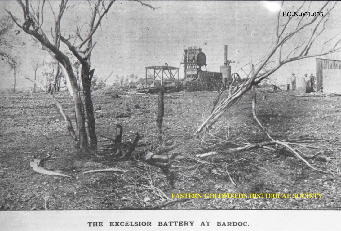
Photo is from the Eastern Goldfields Historical Society’s digitized collection of 60,000 negatives1.
In Western Australia a state battery was a government owned and operated crushing facility that crushed the ore found by prospectors and dug from small mines in the area. The Western Australian Department of Mines were the government agency responsible for their operation. Some of the batteries were only operating for one or two years, while others were in place for 5o or more years. Western Australia was the only state in Australia to provide this type of facility.
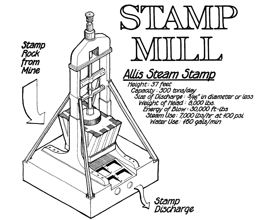
A battery (aka stamp battery, stamp mill or stamping mill) crushes ore by pounding rather than grinding. Each stamp head consists of a set of heavy steel stamps in a vertical frame. The stamp slides up and down crushing the rock. Batteries were gauged by the number of heads, hence a 10-head battery has 10 stamp heads crushing ore.
The first public battery (as they were originally known) was opened at Norsemam in 18982. Prior to this privately owned and operated batteries were the norm. In considering the legislation to establish public batteries, some last minute adjustments to the wording gave the administrators discretion to “assist” private batteries in certain cases3.
I haven’t been able to find out how many state batteries were established, but by the 1930s the total number of batteies (public and private) was close to 100, dropping to less than 50 by 1958. By 1982 a government review of state battery operations resulted in closure of all by 19874. In 1996 the battery at Ora Banda was rebuilt and reopened. Unfortunately, it never crushed any ore and in 2000 it was badly damaged by bombing and has not been rebuilt5.
As at April 2012, Wikipedia published a list of known state batteries in Western Australia (see below) but this list is believed to be incomplete. Do you know of any more? If you do please let us know at ghostswa@fhwa.org.au. While our focus, as always, is on the ghost towns, for completeness this list includes those state batteries that were located at all known sites, ghostly or otherwise!
List of State Batteries known to have existed in Western Australia
Bamboo
Laverton
Nannine
South Greenbushes
Black Range
Leonora
Niagara
Southern Cross
Bulong
Linden
Norseman
Tuckabianna
Carlaminda
Marble Bar
Ora Banda
Tuckanurra
Coolgardie
Marvel Loch
Paddington
Warriedar
Cue
Meekatharra
Paynes Find
Widgiemooltha
Darlot
Messengers Patch
Paynesville
Wiluna
Desdemona
Menzies
Pig well
Yalgoo
Devon
Mt Egerton
Pinjin
Yarri
Donnybrook
Mt Ida
Quinns
Yerilla
Duketon
Mt Keith
Randalls
Youanmi
Dumpling Gully
Mt Sir Samuel
Ravelstone – Peak Hill
Yundamindera
Kalgoorlie
Mulline
Ravensthorpe
* Mt Jackson
Kalpini
Mulwarrie
Sandstone
* Siberia
From Wikipedia article – State Batteries in Western Australia, 2012 * Updated 26 Nov 2023 with additional locations from Gone West by Geoffrey Higham.
The Western Australian Goldfields Courier, Coolgardie, WA : 1894-1898. Norseman Public Battery. 10 Sep 1898, p.23. Retrieved from http://nla.gov.au/nla.news-article251211132 on 26 Nov 2023 ↩︎
The following article was published on page 1 of The Sun newspaper on Sunday, 21 November 1909. I first stumbled across the name of Billy Frost while researching Siberia where he, along with Bob Bonner, discovered gold in 1893.
That well-known prospector, Billy Frost, the discoverer of Goongarrie, Siberia and Burtville, and the pegger out of the Premier at Kunanalling, the third lease applied for on the Coolgardie goldficlds, is again amongst us after prospecting in pretty nearly every goldfield in the world. After a long experience and many hairbreadth escapes, in which his death has been duly chronicled many times, Frost has returned, and is of opinion that Australia is “God’s own country”. Anyhow he is going to have one more try. A syndicate is being formed of 40 shares of £25 each to fix up matters. Frost gets nothing, either in cash or wages, but takes 10 fully paid up shares, which are a pure gamble. Ten further shares are held in reserve for contingencies, while 20 contributing shares, £12 10/ to be called up, are being issued. Of the latter half have been placed in Perth, and goldfielders have now an opportunity to apply for the balance, five of which have already been placed. The Government is backing the venture with camels, and all that Frost requires is tucker for a six to twelve mouths’ trip, which, in the early days he could have got in the twinkling of a star. Frost is staying with Jerry McAuliffe, prospector of the White Feather, Yerilla and other shows, but is rather diffident of being interviewed by members of the fourth, or any other, estate. He starts outback almost immediately.
BILLY FROST. (1909 November 21). The Sun (Kalgoorlie, WA : 1898 – 1929), p.1.1
It seems like Billy was a bit of a lad, and here I may be reading too much into it, but the tone of the article suggests that investing your hard earned in his new venture might be a little risky?
In 1926, in Mackinlay, Queensland, Billy was shot by Mick Ford during an argument. He is buried at Cloncurry2.
In a state that is larger than many countries around the world, you could expect to find some extraordinary stories. Stories of hardship and courage; stories of extreme wealth and extreme poverty; stories of cultural diversity and of bonds formed in adversity; stories of the building of a national identity but also stories of environmental vandalism. It is all there written in the earth. And sometimes the earth is all that is left to mark the passing of the communities that have made up the history of the state. There’s one thing that brings all these stories together – the people who lived them.
2029 will mark two significant Western Australian milestones. The first milestone is the Bicentenary of European settlement. The second is FamilyHistoryWA’s 50th Anniversary. To mark these events, the Society (FHWA) has launched a project to gather together everything we can find about the people who lived in the ghost towns of Western Australia. The project timeframe is six years. The project will be launched in 2029 to coincide with the joint celebrations.
At present the list of identified ghost towns sits at more than 500. Of these perhaps the mining towns are the best known. In the 1901 census the largest towns in Western Australia included the mining towns of Day Dawn, Kanowna, Mount Morgan, and Nannine, all of which are ghost towns today. But there were many other non-mining gazetted towns that reflect Western Australia’s history of building railway lines, a long pipeline from Perth to Kalgoorlie, timber towns (which supplied the railway sleepers), the government-initiated Soldier Settlement and Group Settlement schemes and towns that were created to service spread out farming communities.
Today I have added 36 new Towns to the alphabetical listing on the website. Over the next few days, I will also add them to the “By Region” and “By LGA” listings so that there’s complete functionality.
The towns include:
Candlelight
Emu Hill
Hester
Holleton
Kukerin
Mount Palmer
Toolibin,
…and lots more!
Check the list to see if your town is included!! Contact us if it is missing or if we have something wrong.
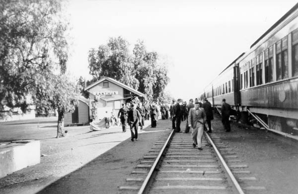
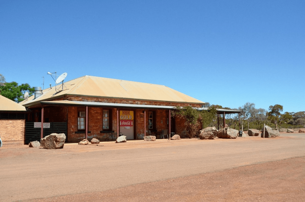
There’s more to Zanthus than its position at the end of every list of Western Australian place names. The name is derived from the latin name for the Kangaroo Paw, Western Austalia’s floral emblem1.
Zanthus appears to have started life as a depot and rail siding during the construction of the Trans Australian Railway. Materials needed for the construction of the railway were sent to Zanthus from Kalgoorlie. Work started on the line (that would join Port Augusta to Kalgoorlie) in 1912 and the line opened in 1917.
The Trans Australian Railway was the main route for the movement of Australian troops during World War II. Here RAAF personnel enjoy a stopover, probably to allow the steam locomotive to take on water, at Zanthus circa 1940 Photo from P Rogers Collection.
In 1921, the census recorded 24 people living at Zanthus and in 1933 there were 26 males and 21 females occupying the same 9 dwellings2. It must have been very crowded! That is the last time Zanthus appears in the census records. However, post 1933 census records carry a couple of caveats. The first is that only localities “in which at least 50 persons were enumerated” are included and that the record is “exclusive of full-blood Aboriginals and of dwellings occupied solely by them”3.
Even so life at Zanthus has never been dull. A quick search of Trove reveals a number of rail-related incidents over the years. In 1948, passengers were stranded when floodwaters washed away tracks and some of the passengers completed their trip in a Golden Airways airplane, and 50 workmen were required to repair the damage4. A derailment in 1953 resulted in tracks being torn up and repair crews worked through the night to have a deviation in place by the following day5. Rain from Cyclone Trixie in 1975 resulted once again in a major washaway, this time requiring construction of a new bridge in just two weeks6. And, as recently as 1999, the Indian Pacific collided with a stationary train on the tracks7. The speed with which each of these incidents was resolved speaks volumes about the continuing importance of the only transcontinental rail link8.
Today, the population of Zanthus is 09 and it appears that it has been that way for a very long time. and Zanthus is a crossing point on the railway where one train pulls off the main line to allow another heading in the opposite direction to pass.
Australian Bureau of Statustics. Census Bulletin No.25 Population and Occupied Dwellings in Localities. 30 Jun 1933. 21 Jan 1936, p.91. https://www.ausstats.abs.gov.au/ausstats/free.nsf/. Accessed 20 Sep 2023 ↩︎
Over the weekend we added 29 more names to the Ghost Towns list. We don’t expect them to be the last. A number of the new listings are schools that have closed in the Shire of Esperance. The list now totals 539. If you know anything about these towns, or know of any that we haven’t yet picked up on, please let us know.
Nungarin North was a small settlement about 2Km north of the current town of Nungarin1.
On 21 Aug 1912, a correspondent from the Merredin Mercury and Central Districts Index reported that that Mr A C McCorry had 700 acres of land to the north of the railway siding at Nungarin. The report continued with the news that Mr McCorry was “erecting a store, a blacksmith’s shop and a stone hotel containing 20 rooms at a cost of £4,000 “2. That roughly equates to $550,000 in today’s money!
This investment seems to have been aimed at encouraging people to move into the area north of the siding as he was also creating several half acre blocks near to the hotel site. The Commissioner of Railways had visited the site and promised to upgrade the Nungarin Siding with the addition of a good shed, lavatories, an extended ramp and the appointment of a man in charge.
Mr McCorry was also a driving force behind the building of an agricultural hall in the area, hosting a fund-raising dance at his home on the 31st March, 1912.
So what happened to Mr McCorry’s entrepreneurial enterprise? Hopefully our ongoing research will tell us and we will let you know.
Source
Joukovsky-Vaisvila, Olga, 1978. Around the Rock: A History of the Shire of Nungarin, Western Australia.↩︎